Marine Technology News Search
Search term • "advanced navigation"
Create an email alert for "advanced navigation"
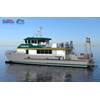
All American Marine to Build Research Vessel for Cal Poly Humboldt
Bellingham, Wash. shipbuilder All American Marine (AAM) announced it has been awarded a contract to build a new research vessel for the marine sciences program at the California Polytechnical Institute at Humboldt (Cal Poly).The vessel is a 78’ x 26.7’ semi-displacement aluminum catamaran that was developed by Nic de Waal of Teknicraft Design in Auckland, New Zealand. The vessel will be inspected to U.S.
ABB to Deliver NINVA Temperature Sensors to eMarine
ABB will deliver 1,500 NINVA non-invasive temperature sensors approved for marine use to eMarine, a Swedish company dedicated to enabling efficiency and sustainability in the maritime industry. NINVA will complement eMarine’s advanced energy management solutions already deployed on major cruise and cargo vessels worldwide.The data collected by the innovative NINVA temperature sensors will play a key…

The Top 10 Offshore Wind Energy Trends to Watch in 2023
The drivers for global offshore wind growth look good for 2023. Global offshore wind is forecast to grow from over 60 GW at the end of 2022 to 240 GW by 2030 and over 410 GW by 2035. But the sunny outlook must be balanced with some building dark clouds. As we prepare for the new year, let us look at ten factors that will shape the offshore wind sector in 2023.1. Solid foundations: Optimism for the…
Kawasaki's AUV Used to Inspect Coating Defects on Subsea Pipeline
Japan's Kawasaki Heavy Industries said Thursday it had, with French energy supermajor TotalEnergies, completed its joint offshore verification test measuring the electrical potential of subsea pipelines during close-range inspections using an AUV (Autonomous Underwater Vehicle). The test was conducted off Awaji Island (Hyogo Prefecture, Japan)Kawasaki has been developing the world’s first AUV with a robot arm for subsea pipeline inspections…

ASL Hires Chawarski as Biological Oceanographer
ASL Environmental Sciences Inc. announced the appointment of Julek Chawarski to the position of Biological Oceanographer. Chawarski contributes nearly a decade of experience in fisheries science, with expertise in forage fisheries and biological oceanography in coastal and deep ocean ecosystems. He will be responsible for developing consulting services for ASL's ocean monitoring clients and will develop new tools for hydroacoustic studies of aquatic ecosystems.Previous to his appointment at ASL…
VideoRay ROVs Protect Busy Ports and Waterways
Port security and surveillance, mine countermeasures and underwater search and rescue are all dangerous missions that should no longer put lives or vessels at risk. Where sustained, mission critical underwater inspection or exploration is required, remotely operated vehicles (ROVs) are the safest and most effective way to maintain security, support salvage efforts and uncover secrets of the ocean.Video…
Bedrock Scores $8M in Funding to Fast Track Ocean Data Initiatives
Bedrock Ocean Exploration, which was created to make the business of gathering, processing and disseminating accurate information on the world’s oceans to key stakeholders, has raised an $8M seed round from Eniac Ventures, Primary Venture Partners, Quiet Capital and R7.The funding is targeted to help Bedrock scale their robotics and cloud software to map the ocean floor more efficiently than ever, effectively removing people & ship-centric acquisition operations.
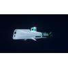
HII and Shield AI Partner on Autonomy for ROMULUS USVs
HII and Shield AI have successfully completed the first major test of their integrated autonomy solution aboard HII’s ROMULUS unmanned surface vessel (USV).The three-day test, conducted in late October in Virginia Beach, Virginia, integrated Shield AI’s combat-proven Hivemind autonomy software, using the Hivemind Enterprise software development kit (SDK), with HII’s Odyssey autonomy suite onboard a ROMULUS 20 USV.The test also marked the first maritime deployment of Hivemind…
Italy's TSO Tests Subsea Drone for Marine Geophysical Surveys
Italian transmission system operator (TSO) Terna has launched an autonomous underwater vehicle (AUV) Gavia as part of a collaborative project with U.S. start-up Terradepth.Terna and Terradepth are working together on the Odisseo project, whose aim is to advance the technologies and methods for marine geophysical surveys related to the development of important subsea infrastructure and its security.As part of the Odisseo project…

Finland-based Pipeline Inspection Firm Rocsole Wins Another OTC Award
Rocsole, a Finland-based developer of offshore pipeline inspection technology, has received an Offshore Technology Conference (OTC) Spotlight on New Technology award for a system that inspects pipelines while allowing production to continue without interruption.The award was given to Rocsole for its Deposition In-Line Inspection (DILI) system. DILI system uses a non-nuclear tomographic technology to inspect pipelines for deposition build-up thickness…
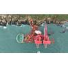
Sulmara Assists Fuel Recovery Op from Typhoon-Struck Cargo Ship
Scottish subsea specialist Sulmara has supported a major fuel recovery operation from typhoon-struck cargo ship in shallow waters off Taiwan.At the request of the Taiwanese government, Sulmara mobilized a WAM-V 16 uncrewed surface vehicle (USV) and a team of survey specialists to assist in the emergency fuel recovery operation for the heavy transport vessel, Yu Zhou Qi Hang.The operation was launched…
10 Tech Trends to Impact Shipping Industry
A new report has identified the ten technology trends, and their associated risks, that will shape industry and society in the coming decade.The rapid advancement of digitalization is behind many of the trends, profoundly challenging our personal and societal assumptions, according to DNV GL, the global risk management and quality assurance company.The report 'Technology Outlook 2030' said that the relationship between humans and technology is switching…
Sonardyne Partners with Smart Sound Plymouth
Marine energy, defense and science company Sonardyne has been selected to provide a subsurface communications and navigation network for the Smart Sound Connect Subsurface (SSCS) Project. Sonardyne will partner with the University of Plymouth and Plymouth Marine Laboratory to install, operate and manage an underwater acoustic communications and navigation network that will link to the existing surface assets.Located in the city of Plymouth and the waters in and around Plymouth Sound…
FET Observation-class ROV for Memorial University
Forum Energy Technologies (FET) secured a contract from the Memorial University of Newfoundland to supply an electric observation-class remotely operated vehicle (ROV) to its Fisheries and Marine Institute (MI), School of Ocean Technology.The primary function of the Sub-Atlantic Mohican ROV system will be to support ocean research, while it will also be used for pilot technician training. For ocean research operations…
No Need for Mothership: Kongsberg Launches HUGIN Endurance AUV
Norway's Kongsberg Maritime has announced the next generation of its HUGIN Autonomous Underwater Vehicle (AUV) that can carry out long missions without a mothership.Named HUGIN Endurance, Kongsberg Maritime says its new AUV boosts operational duration to approximately 15 days, enabling extended survey and inspection missions far from shore."This longevity allows HUGIN Endurance to undertake extensive missions without the support of a mothership.
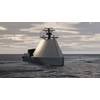
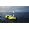
Sonardyne's Sensors for Ocean Infinity's Armada USV Fleet
Ocean Infinity, a U.S. based marine survey firm developing the world's largest fleet of unmanned surface vessels - Armada - has ordered Sonardyne sensors for its robotic vessels.As reported previously, Ocean Infinity in February launched Armada, a marine technology and data company boasting the industry's largest fleet of unmanned surface vehicles (USV).Sonardyne said Wednesday it would provide the…
Saildrone Closes $100 Million Series C Funding Round
Saildrone in mid-October announced the close of its $100 million Series C round, bringing its total funding to $190 million.Led by BOND, the round includes new investors XN, Standard Investments, Emerson Collective and Crowley Maritime Corporation, as well as participation from previous investors, Capricorn’s Technology Impact Fund, Lux Capital, Social Capital and Tribe Capital. Saildrone said it will…
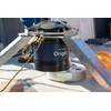
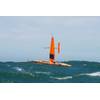
Ørsted Unveils USV for Met-ocean Measurement
Leading offshore wind developer Ørsted announced it has developed an uncrewed surface vessel (USV) for offshore met-ocean measurement campaigns.The USV was invented by Ørsted employees and has been designed as a generic platform for a range of sensor instrumentation and is able to collect large amounts of data on, among other things, wind conditions, state of the seabed and biological and ecological…

Greensea Continues to Grow, Gill Joins Team
Sunnyvale, CA Native Karnveer Gill is Passionate about Algorithm Design and New Technology DevelopmentGreensea, creator of OPENSEA, the open architecture robotics platform for the marine industry, has hired Karnveer Gill, Junior Robotics Engineer, to help advance OPENSEA’s software tools and applications. Karnveer received his electrical engineering Bachelor of Science degree from San Francisco State…
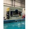
AUV Case Study: Marine Roboticists are Turning AUV Sight into Perception
In 2018, marine robotics scientist Arjuna Balasuriya was at the Advanced Naval Technology Exercise (ANTX) in Newport, Rhode Island, testing new software for an autonomous underwater vehicle (AUV). In the past, his AUV research had meant long ocean cruises in rough choppy waters, but for the moment, he was analyzing his algorithms from a comfortable dry seat on land.Balasuriya and his team from Charles River Analytics were developing an app for the AUVs made by Teledyne Gavia…


