NOAA: Operational Forecast System Informs Shipwreck Oil Spill Scenarios
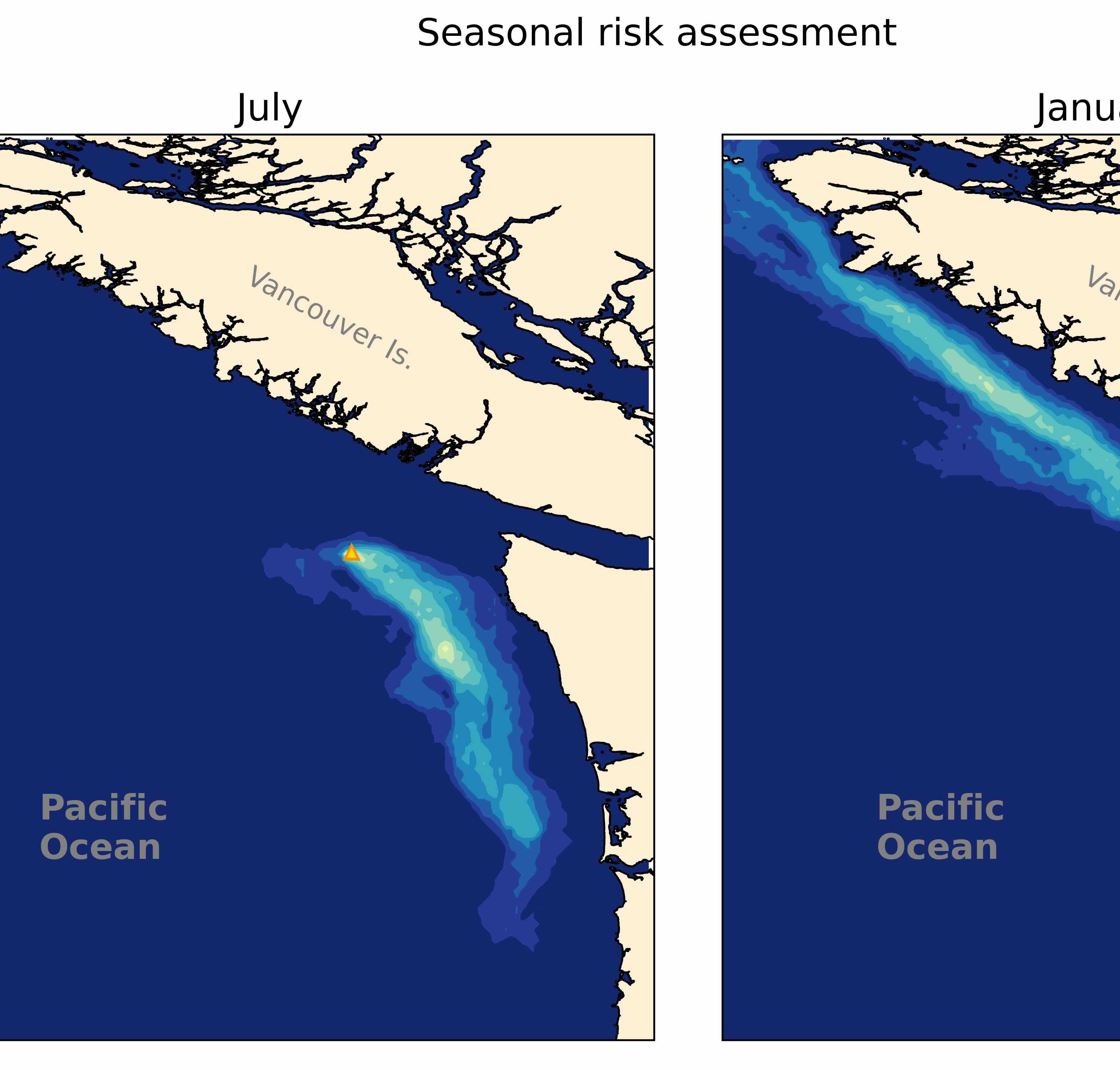
Aggregated results from model simulations showing dramatic differences in impacts based on the timing of a potential spill. In a July scenario (left panel), the spill is most likely to move south, towards the coast of Washington state. In a January scenario (right panel), the spill is most likely to flow north, potentially affecting the coast of Vancouver Island, Canada. © NOAA
During World War II, the 334-foot, 5,350-ton SS Coast Trader was hit by a torpedo and sank off the coast of Cape Flattery, Washington.
Resting almost 500 feet below the surface, the Coast Trader has an estimated 542 tons of heavy fuel oil remaining in the fuel tanks. The quantity onboard the Coast Trader is equivalent to 60% of the volume of fuel spilled into the Pacific Ocean near Grays Harbor by the barge Nestucca in 1988, which remains one of Washington’s largest and most damaging oil spills.
In collaboration with Fisheries and Oceans Canada (DFO), NOAA’s Office of Response and Restoration (OR&R) began a comprehensive assessment of potential impacts from the Coast Trader’s fuel in the event that corrosion leads to a release of oil. As part of this assessment, the team used NOAA’s GNOME trajectory model for modeling potential spill paths and impacts to the coastline, as well as NOAA Office of Coast Survey’s West Coast Operational Forecast System, which provides water level, current, temperature, and salinity nowcast and forecast guidance.
The team ran approximately 400 spill scenarios, at random dates and times, to model potential paths and the impacts on the coastline. Using these model results, NOAA was able to provide the Canada-U.S. Joint Response Team with seasonal risk assessments to assist with their CANUSPAC response drill in November 2024 and to help mitigate potential impacts to coastal communities, should a major spill from this sunken vessel occur. The Coast Trader spill response was chosen as the spill scenario for the drill, with the results posted on OR&R’s WebTAP for the CANUS Joint Response Team to review and use as part of their drill scenario preparations.
“Model products from the Office of Coast Survey are critically important for providing OR&R with accurate, real-time information for response operations and proactive projects like these that can help mitigate impacts before they occur,” explains Dr. Rachael Mueller, a Genwest contractor with OR&R and the oceanographer who led the model development for this project. The team also included GNOME modeling experts Amy MacFadyen from OR&R and OR&R contractors Dylan Righi, Jay Hennen, and Gennady Kachook from Genwest Systems, Inc.
This is just one example of the utility of three-dimensional ocean forecast systems that are being developed and tested at Coast Survey to guide safe navigation, search and rescue efforts, and environmental hazard responses in waters within the U.S. Exclusive Economic Zone.