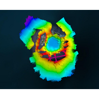
USV Collects 'Astounding' Data from First Caldera Survey in Tonga
2030’s mission of a complete map of the entire ocean floor. By surveying areas that may not be accessed by personnel for safety reasons, USVs, such as SEA-KIT’s Maxlimer, will greatly assist us in our ambitious goal.”Findings from the TESMaP project will be presented at the American Geophysical Union (AGU) Fall Meeting in Chicago this December, a highly influential event dedicated to the advancement of Earth and space sciences

Kapnick Named NOAA Chief Scientist
website. She also led NOAA’s participation in NASA’s High Mountain Asia Team, a collaborative research project to study cryospheric change and associated hazards. She began her career working as an investment banking analyst with Goldman Sachs Group Inc.Kapnick is a member of the American Geophysical Union, American Meteorological Society and American Association for the Advancement of Science.She received a Ph.D. in Atmospheric and Oceanic Sciences with a Certificate in Leaders in Sustainability from the University of California, Los Angeles, and an A.B. in Mathematics with a Certificate
Lander Lab: Technologies, Strategies and Use of Ocean Landers
;D, with emphasis on the D.The concept of ocean landers/free vehicles for geophysical research was first proposed in 1938 in a brilliant paper by Maurice Ewing (Lamont) and Allyn Vine (WHOI), titled “Deep-Sea Measurements Without Wires or Cables,” published in Transactions of the American Geophysical Union. Many of its insights are still valid today. The authors cited operational benefits of ocean landers/free vehicles including:Much less specialized and expensive equipment required on the ship;Long, undisturbed placement of recording instruments on the bottom;Recall by time-clock or
The Arctic: Scientists Aim to Improve Sea Ice Predictions' Accuracy, Access
and monitoring network 14 years ago.“These forecasts are quite encouraging in their increasing accuracy,” said Uma Bhatt, an atmospheric sciences professor at the University of Alaska Fairbanks Geophysical Institute. Bhatt spoke about the Sea Ice Prediction Network at the American Geophysical Union’s annual meeting last month.As the amount of sea ice in the Arctic declines, thins and becomes more mobile, accurate forecasts are becoming even more vital for things like fisheries and resource development, shipping, subsistence activities and wildlife management.Bhatt said the SIPN
Researchers Find Mysterious Seafloor Holes
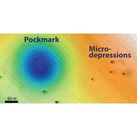
of mysterious holes or pits in the seafloor. Scientists and resource managers want to understand how these pits formed because this area is the site of a proposed wind-energy farm. Researchers Eve Lundsten and Charles Paull describe their discovery this week at the Fall 2019 meeting of the American Geophysical Union in San Francisco.The researchers found two different sizes of holes. The larger ones, known as pockmarks, average 175 meters (almost 600 feet) across and five meters (16 feet) deep, and are nearly circular and fairly evenly spaced. Some of these pockmarks were initially discovered by MBARI
Saildrone Hires New Chief Scientist
of Technology (1977) and Physical Oceanography from the University of Washington (1983). His scientific interests include the circulation of the ocean and air-sea exchange processes and include extensive experience in both sea-going oceanography and remote sensing. In 2013, he received the American Geophysical Union Ocean Sciences Award for leadership and service to the ocean science community.“Saildrone is the best solution for many in-situ observing requirements. The global reach of the Saildrone fleet and its ability to collect high-quality data on air-sea interaction, gas transfer, biodiversity
WHOI Names Murray Deputy Director & VP for Research
many research cruises in various capacities around the globe, and authored or co-authored approximately 100 peer-reviewed research papers. He is a Fellow of the Geological Society of America, a former councilor of The Oceanography Society, and currently serves on the Board of Directors of the American Geophysical Union.Murray received his undergraduate degree from Hamilton College, and also graduated from the Sea Education Association’s program in Woods Hole. After receiving his Ph.D. from the University of California, Berkeley, he was a post-doctoral scholar at the Graduate School of Oceanography
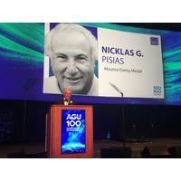
Oceanographer Pisias Honored by US Navy, AGU
A pioneering oceanographer has been awarded by the U.S. Navy and the American Geophysical Union (AGU) for his work to help establish a new scientific field.Dr. Nicklas Pisias, a professor emeritus at Oregon State University, accepted the Maurice Ewing Medal at the December 2018 Fall Meeting of the AGU, a not-for-profit, scientific organization with nearly 60,000 members in 139 countries.The medal, named after trailblazing geophysicist and oceanographer Dr. Maurice Ewing, is given yearly to one honoree in recognition of “significant original contributions to the ocean sciences.”In the late
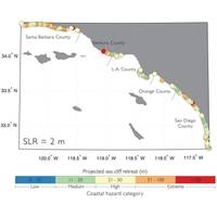
Sea Level Rise Could Speed Erosion in Southern California
Santa Barbara to San Diego might crumble at more than twice the historical rate. Why?U.S. Geological Survey scientists combined several computer models for the first time to forecast cliff erosion along the Southern California coast. Their peer-reviewed study published in a recent issue of the American Geophysical Union’s Journal of Geophysical Research - Earth Surface showed that for sea-level rise scenarios ranging from about 1.5 feet to 6.6 feet by 2100, bluff tops along nearly 300 miles of Southern California coasts could lose an average of 62 to 135 feet by 2100 – and much more in some