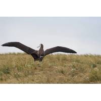
Study Identifies "Collision Map" For Birds, Boats to Support Conservation Efforts
– males and females, juveniles and adults, breeding and non-breeding individuals – were fitted with tiny satellite transmitters. The full scope of the birds’ movements across the vast Southern Ocean was then overlaid with precise fishing vessel locations from the Automatic Identification System (AIS), which tracks commercial ships. This showed where birds and boats crossed paths – the basic “collision map.” A third layer was then added: oceanographic data. PML’s expertise in Earth observation was used to examine how physical ocean features shape

Teledyne Expands Maritime Tech Solutions Portfolio with Latest Acquisition
;s Raymarine, FLIR Marine, ChartWorld and Teledyne CARIS brands, broadening the group’s maritime technology solutions.Based outside of Linköping Sweden, the company will market its products and solutions as FLIR TransponderTech.The brand will continue developing and delivering Automatic Identification System (AIS), VHF Data Exchange System (VDES), and Global Navigation Satellite System (GNSS) technologies for civil and military customers in shipping, marine traffic, airborne and space segments. “We are delighted to welcome the TransponderTech team to the Teledyne family. From
Teledyne to Acquire TransponderTech from Saab
Teledyne Technologies Incorporated announced that it has entered into an agreement to acquire the TransponderTech business from Saab AB. The acquisition includes a portfolio of connected commercial maritime products, including Automatic Identification System (AIS), VHF Data Exchange System (VDES), and Global Navigation Satellite System (GNSS) technologies.Based in Sweden, TransponderTech provides class-leading, SOLAS (Safety of Life at Sea)-certified communications and navigation solutions for commercial maritime, military, and airborne applications. The company is known for its high quality, accurate

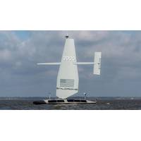
Saildrone: USVs Have Only Scratched the Surface of Maritime Security
at Saildrone exceeded the capabilities of the Explorer due to power or speed or size constraints. or all three."Next came Voyager, a 10-meter diesel-hybrid USV that serves as the primary platform for maritime security and shallow water mapping. It features a high-powered radar, automatic identification system (AIS) and a pan-tilt-zoom flare camera. It can also be equipped with shallow-water multi-beam sonar and a sub-bottom profiler. "That's what really gives us that large area coverage; we can conduct geophysical surveys, safety of navigation, offshore energy projects, and subsea
Struggles to Secure Baltic Sea Dominates NATO's 'Freezing Winds '24'
, Commander Pal Bratbak, said onboard the Weilheim, stressing the growing power of technology.NATO's Center for Maritime Research and Experimentation in Italy is launching software that will combine private and military data and imagery from hydrophones, radars, satellites, vessels' Automatic Identification System (AIS) and fibres with Distributed Acoustic Sensing (DAS), which private telecom companies use to localise cuts in their cables."If we have a good picture of what's going on, then we can deploy units to verify what the system tells us," Bratbak said.German Lieutenant-General
Maritime Risk Symposium 2024 – Great Power Competition and Gray Zone Engagement
conflict, making attribution and response difficult. Artificial intelligence (AI) offers promising solutions to enhance the detection, analysis and mitigation of gray zone cyber threats in the maritime sector. This panel will explore the potential of AI to counter tactics like GPS spoofing, Automatic Identification System manipulation and attacks against port infrastructure. It will examine how machine learning-based systems can identify anomalies in network behavior, detect subtle patterns associated with gray zone activities and automate threat intelligence analysis. The panel will also address the
Saildrone Launches First Next-gen Surveyor USV
first vehicle launched of many that will be produced here in Alabama,” said Saildrone founder and CEO Richard Jenkins. “Everyone at Saildrone is very proud to be supporting the US Navy and contributing to our defense and national security.”The Surveyor fuses radar, cameras, automatic identification system (AIS), and advanced machine learning to deliver comprehensive situational awareness remotely from anywhere in the world. Saildrone offers solutions for challenges like IUU fishing, counter smuggling, and safety of life at sea (SOLAS) missions. The Surveyor detects vessels at sea, even
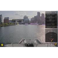
Sea Machines Debuts AI-ris Computer Vision for Commercial Vessels
or animals, to those very large, like another ship,” said Trevor Vieweg, CTO, Sea Machines. “With the ability to detect, classify and geolocate such targets via optical sensors, AI-ris augments and surpasses the capabilities of existing marine sensor technologies, like radar and automatic identification system (AIS), enabling greater performance and achieving the highest levels of safety. In the future, this technology may also help responders detect marine oil spills.”AI-ris is commercially available now and can be installed aboard existing vessels, as well as new-builds
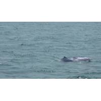
Unmanned Vessels Help to Protect Threatened Marine Lives in China
Pearl River Estuary Chinese White Dolphin National Nature Reserve.Besides population exploitation, USV technologies also play significant roles in guarding the natural reserve. An autonomous surveillance and rescue vessel is also used for daily patrolling along the set route. Radar and AIS (Automatic Identification System) are applied to real-time monitoring, automatically recording vessels' sailing paths and alerting suspected vessels. Natural reserve protection has become more intelligent and efficient with advanced USV technologies.The Autonomous Surveillance and Rescue Vessel is Expelling a Suspicious