Phase 1 of S-100 Implementation Complete
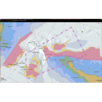
alerts can now be directly integrated into the chart display on vessels equipped with S-100 ECDIS.The S-128 Catalogue of Nautical Products allows systems to automatically track the status of subscribed navigational data services, indicating which are up-to-date, available, or missing.The Canadian Hydrographic Service (CHS) is taking a leading role in validating the new S-100 hydrographic framework with the June 2025 launch of sea trials on the St. Lawrence River. The primary objective of the six-month trial is to enable software developers and end users to start working with real data before the framework&

S-100 has Value Beyond ECDIS
so that they don't encounter any issues with things that may cause marine pollution.“I think that's a really good use case for S-100 data that we hadn't necessarily considered when we were looking at all of the benefits of having access that information.”In June, the Canadian Hydrographic Service (CHS) is taking a leading role in validating new digital hydrographic standards by launching S-100 sea trials on the St. Lawrence River
Canada Trials S-100 on St. Lawrence River
The Canadian Hydrographic Service (CHS), under Fisheries and Oceans Canada, is taking a leading role in validating new digital hydrographic standards, with the Minister of Fisheries, Joanne Thompson, launching S-100 sea trials on the St. Lawrence River.The S-100 data model is a new global standard created by the International Hydrographic Organization (IHO), which offers a new way of visualizing the marine environment using layered, interactive digital data that can be added to navigational charts. Unlike traditional paper or electronic charts, the new standard integrates real-time information –
Fugro to Deploy Latest RAMMS Tech to Map Lake Huron
Fugro is mobilizing its Rapid Airborne Multibeam Mapping System (RAMMS) to Ontario, Canada, to acquire 3,147 square kilometers of high-resolution bathymetry data over Lake Huron for the Canadian Hydrographic Service (CHS).The survey is expected to last six months from data collection to data delivery and will support the agency’s ongoing nautical charting updates in the country’s Great Lakes region.Fugro has used RAMMS throughout North America, the Caribbean and Europe since launching the next-generation airborne lidar system in 2018. In addition to nautical charting, RAMMS has supported
NOAA Awards 5-yr Hydrographic Gig to Fugro
services with increased safety and efficiency, and a significantly reduced carbon footprint.Two new technologies available to NOAA for upcoming task orders include RAMMS, a next-generation airborne lidar bathymetry system already used by the United Kingdom Hydrographic Office and the Canadian Hydrographic Service, and an uncrewed surface vessel (USV) designed for coastal surveys in challenging areas of shallow water, uncharted shoals and/or water clarity issues.The new IDIQ contract will run from 1 January 2020 to 31 December 2024. Fugro is one of seven contractors who will receive task orders
Seabed 2030 Meeting Held in Stockholm
measurement techniques. In total, the meeting identified numerous sources of new bathymetric data. The combined area of these contributions in terms of square kilometers will be announced later this year.Organizations presenting details on their mapping efforts to the group included the Canadian Hydrographic Service; the Danish Geodata Agency; the Italian Ministry of Defense; the Norwegian Hydrographic Service; the US National Geospatial-Intelligence Agency; Italy’s National Institute of Oceanography and Experimental Geophysics; Fugro; Kongsberg Maritime; TE Subcom; the Geological and Mining
Canadian Hydrographic Service Grows Its USV Fleet
The Canadian Hydrographic Service (CHS) has taken delivery of two additional autonomous unmanned surface vehicles (USVs), bringing its fleet to four systems.The 2.5-meter USVs, built and delivered by Florida based SeaRobotics Corporation, are complete hydrographic systems including multibeam echo sounders, support sensors, cast winches, deployment carts and road trailers.The SeaRobotics USVs are being deployed across Canada supported by regional training performed by SeaRobotics. CHS, part of Fisheries and Oceans Canada, has completed the first year of operation and the analysis of the efficiency and
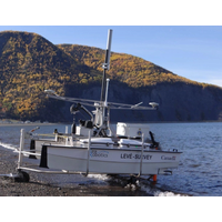
Hydrographic Survey Vessel Converted for Autonomous Ops
a 26ft hydrographic survey launch to enable it to operate autonomously using the ASView control system, while maintaining its ability to operate in a conventional manned mode. The launch, which is part of the Canadian Coast Guard’s (CCG) fleet dedicated to the survey operations of the Canadian Hydrographic Service (CHS), will be used as a test platform for unmanned survey work. This delivery to the CHS marks ASV Global’s 10th unmanned conversion of a customer vessel using the ASView system. ASView enables the launch to follow planned missions giving it the capability to
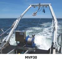
AML Acquires Rolls-Royce’s MVP Product Line
of end-to-end vertical profiling solutions for our core hydrographic customers. We look forward to breathing new life into the technology.” The MVP user base is distributed throughout Europe, Asia, North America and South America, and includes such hydrographic leaders as the Canadian Hydrographic Service, the Naval Oceanographic Office (NAVO) and NOAA. AML said it now owns the global rights to manufacture new systems and support of the existing install base. Going forward, MVP activities will be managed out of AML’s Dartmouth, Nova Scotia office, where AML&rsquo


