Fugro Maps Elevation in Texas River Basins to Bolster Flood Resilience
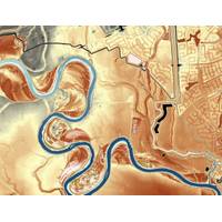
Fugro is undertaking an elevation‑mapping project to support flood‑risk and infrastructure planning across south central Texas. Commissioned by the Texas Water Development Board (TWDB), the work spans the Guadalupe, San Antonio, Lower Colorado, and Lavaca river basins, covering approximately 41,381 square kilometers across 34 rapidly growing communities. Many of these areas have faced repeated flooding in recent years, prompting local authorities to update hazard‑mitigation plans and improve drainage, transport and water systems.The work is being delivered through the Texas Geographic Information
Antarctic Sea Ice Extent Reaches Seasonal Minimum
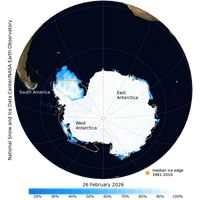
Antarctic sea ice has likely reached its minimum extent for the year, at 2.58 million square kilometers (996,000 square miles) on February 26, 2026, according to scientists at the National Snow and Ice Data Center (NSIDC) at the University of Colorado Boulder.The 2026 minimum ranks 16th lowest in the 48-year satellite record. This year’s minimum is much closer to average than the past four years, albeit still 260,000 square kilometers (100,000 square miles) below the 1981 to 2010 average. It is 730,000 square kilometers (282,000 square miles) above the record low set on February 21, 2023.
Argentina’s Deep Sea Is More Biodiverse Than Scientists Thought
extent until this expedition. The team found Bathelia reefs 600 kilometers (373 miles) further south than its known range, at 43.5° latitude.ROV pilots filmed the remains of a deceased whale that had dropped to the seafloor, called a whalefall, at about 3,890 meters deep during a dive on the Salado-Colorado Kilometer scarp in the Argentine Basin. Whale falls offer up thousands of years of nourishment to a place accustomed to scarcity. From large scavengers to invisible microbes and bone-eating Osedax worms, there is something for all creatures that happen upon a whale fall. Once organic matter has
Scientists Discover Six Million Year Old Ice in Antarctica, Offers Unprecedented Window into a Warmer Earth
in Antarctica is supported by the U.S. Antarctic Program and funded by NSF. Ice drilling support is provided by the NSF U.S. Ice Drilling Program and ice sample cIce drilling support is provided by the NSF U.S. Ice Drilling Program, and ice sample curation by the NSF Ice Core Facility in Denver, Colorado
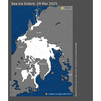
Arctic Sea Ice Hits Record Low Maximum Extent for the Year
Arctic sea ice has likely reached its maximum extent for the year, at 14.33 million square kilometers (5.53 million square miles) on March 22, according to scientists at the National Snow and Ice Data Center (NSIDC) at the University of Colorado Boulder.The 2025 maximum sea ice extent is the lowest in the 47-year satellite record, falling short of the previous record low of 14.41 million square kilometers (5.56 million square miles) set on March 7, 2017.“This new record low is yet another indicator of how Arctic sea ice has fundamentally changed from earlier decades,” said NSIDC senior
Kraken Robotics Acquires 3D at Depth
in water depths of more than 300m, and capabilities like non-contact vibration and temperature measurement. 3D at Depth’s expertise in Remote Operations also enables scalable, fully remote metrology solutions.3D at Depth’s headquarters and production facility are based in Longmont, Colorado with offshore service operations based out of Houston, Texas, and satellite offices in Norwich and Aberdeen, UK.

NOAA Scientist Dismissals Spark Protests
More than 1,000 demonstrators gathered outside the National Oceanic and Atmospheric Administration (NOAA) building in Boulder, Colorado, on Monday, protesting sweeping layoffs imposed by the Trump administration. According to two current employees, the cuts affected more than 10% of the scientific workforce at the facility.The rally was spearheaded by former U.S. Congressman David Skaggs, a Democrat from Colorado, after whom the NOAA building in Boulder is named. Skaggs, initially expecting only around 100 participants, was surprised by the large turnout, with police estimating attendance at over 1,000.
Warming Predictions Point to Need for Adaption as well as Decarbonization
other extremes. This study suggests that, even in the best case scenario, we are very likely to experience conditions that are more severe than what we've been dealing with recently," said Stanford Doerr School of Sustainability climate scientist Noah Diffenbaugh, who co-authored the study with Colorado State University climate scientist Elizabeth Barnes.For the new study, Diffenbaugh and Barnes trained an AI system to predict how high global temperatures could climb, depending on the pace of decarbonization. They trained the AI with temperature and greenhouse gas data from vast archives of climate
Arctic Sea Ice Could Reach Turning Point by 2027
The first summer on record that melts practically all of the Arctic’s sea ice, an ominous milestone for the planet, could occur as early as 2027.That’s according to an international research team, including University of Colorado Boulder climatologist Alexandra Jahn and Céline Heuzé from the University of Gothenburg in Sweden. The team used computer models to predict when the first ice-free day could occur in the northernmost ocean.When the Arctic Ocean has less than 1 million square kilometers of ice, scientists say the Arctic is ice free.In September, the National Snow and


