![Aerial view of the Rock Islands and coral seascape at the Republic of Palau. [Photo credit: The Nature Conservancy]](https://images.marinetechnologynews.com/images/maritime/w200h200padcanvas/aerial-view-rock-165050.jpg)
Bezos Funds AI Nature Projects
span five continents, from an AI-driven coral reef monitoring network in the Pacific to a weather forecasting model designed for African farmers.The awardees were chosen following a global innovation sprint supported by partners including Amazon Web Services, Google.org, Microsoft Research, Ai2, and Esri, who provided mentorship, tools, and computing resources to help move ideas from concept to impact.Plymouth Marine Laboratory (PML) was one of the 15 selected. The university’s project involves advancing its Deep Vision project to use AI to greatly accelerate mapping of vulnerable marine ecosystems

Geo Sessions 2025
Last year, Geo Sessions brought together over 5,300 registrants from 159 countries, with attendees representing education, government agencies, consulting, and top geospatial companies like Esri, NOAA, Airbus, Planet, and USGS. At this year's Geo Sessions, NV5 is raising the bar with a focus on artificial intelligence, thermal imaging, and hyperspectral capabilities, technologies that are transforming how organizations see, understand, and act on geospatial data.“Last year’s sessions proved there’s a huge appetite for actionable geospatial knowledge,” said Dan
Fugro, SDG Data Alliance Partner to Strengthen Climate Resilience in the Caribbean
platform within the SIDS Centre of Excellence. The work will also be aligned with the Antigua and Barbuda Agenda for SIDS (ABAS), a roadmap adopted at the 2024 UN SIDS4 Conference to help island nations achieve resilient prosperity.This new partnership follows Fugro’s recent agreement with Esri, a founding member of the Data Alliance, to expand access to essential data and tools for climate resilience. It also comes ahead of next week’s fifteenth session of the UN Committee of Experts on Global Geospatial Information Management (UN-GGIM), where Dr. Valrie Grant, a geospatial professional
Fugro, Esri Join Forces for Climate Resilience
Fugro has entered into a strategic collaboration with Esri, a geographic information system (GIS) software specialist, to provide integrated geospatial solutions that empower climate resilience decision-making and sustainable development.Initially, the joint effort will focus on tackling the environmental challenges of Small Island Developing States (SIDS), starting with SIDS in the Caribbean.Nearly 22 million people in SIDS live less than six meters above sea level, placing communities and infrastructures at high risk from coastal hazards. Yet, data gaps remain a major barrier.Many countries don’

Lending Oceans a Robotic Hand
to understand what’s down there and how it can be both used and protected.The latest Marine Technology Reporter’s Deep Dive podcast, released this week, takes up the challenge. Rhonda Moniz speaks to oceanographer Dr. Dawn Wright, Chief Scientist at Environmental Systems Research Institute (ESRI), about the role that mapping plays in maintaining a balance between human activities and protected areas.Growing up in Hawaii, she was drawn into the marine research work by her close association with the ocean as well as by her childhood fascination with Jacques Cousteau and American astronauts
NOAA and Esri Collaborate to Revolutionize Ocean Data Accessibility
In a move to enhance the accessibility and utility of ocean and coastal data, NOAA (National Oceanic and Atmospheric Administration) and Esri, a global leader in location intelligence, have announced a new partnership to develop a pioneering open data platform. This initiative aims to make critical oceanic and coastal data more actionable and equitable for decision-makers and communities.The collaborative effort will combine NOAA’s extensive and high-quality oceanic data with Esri’s advanced geospatial technologies. The goal is to create a fully interoperable platform that transforms
TCarta Plans Bathymetric Mapping Workshop for Jamaica
week of February 5, 2024, at the NLA Surveys & Mapping Division headquarters in Kingston, Jamaica, the workshop will instruct participants in the use of satellite-derived bathymetry (SDB) technology with the TCarta Trident Geoprocessing Toolbox. The software-as-a-service SDB Toolbox operates within Esri ArcGIS Pro and enables users to perform their own extraction of bathymetric measurements from satellite, aerial, and UAV imagery.“TCarta greatly appreciates Seabed 2030’s continuing commitment to expand hydrographic mapping education around the world,” said TCarta President Kyle
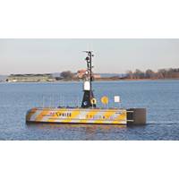
Ocean Discovery XPRIZE Finalists to Compete off Greece
the Mayor of Kalamata, Municipal Port Fund of Kalamata, Hellenic Coast Guard/Central Port Authority, and the Hellenic Center for Marine Research to ensure smooth operations by providing logistical assistance. Competition organizers also continue to work with Fugro, an industry leader in ocean mapping; and Esri, the global leader in geographic information system (GIS) software. XPRIZE is also partnering with Singularity University, which is hosting the SingularityU Greece Summit in November, at which Dr. Peter H. Diamandis, XPRIZE founder and executive chairman of XPRIZE, will give the opening keynote and
Mapping the Future
the Data group during Round 1 overseeing the logistics of the group and the development of the data workflow.Can you describe some of the data processes you are using to enable GEBCO-NF to reach its aims of mapping the world’s oceans?We are using existing software such as CARIS HIPS & SIPS and ESRI ArcGIS. The main goal of the Data team is to make our workflow as autonomous as possible and to reduce processing time. When we put an aim such as mapping the world’s ocean the first thing is to develop equipment, however, then we are facing another big challenge – how to efficiently process