
Unique Group Targets Growth in Europe
has more than 25 years of experience in Europe with a track record in the subsea construction, diving and IRM industries. Gordon is now heading the region with immediate effect.Gordon has over 22 years of experience in the subsea oil and gas industry, with previous senior management roles held in Fugro Survey, Subsea7 and Viking Seatech. His last role before joining Unique Group was as Managing Director – UK at Atlantic Offshore, an emergency response and rescue vessel provider
Interview: David Millar, Fugro
all are contributing crowd sourced bathymetry data to Seabed 2030 as they transit between projects. The same service can be modified and offered to cruise lines and maritime shipping companies, who obviously operate vessels that are already equipped with satellite communications and navigation systems.Fugro survey vessel Kobi Ruegg (Photo: Fugro)With the demand for geophysical data perhaps blunted by the offshore energy downturn, discuss where, today, you see opportunities for your products and services.There is no doubt that the offshore energy downturn has been hard on Fugro and other companies that were
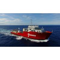
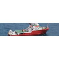
MV Kobi Ruegg Joins Fugro Survey Fleet
A 58-meter, multi-role survey vessel MV Kobi Ruegg has joined Fugro’s fleet and is set to begin her first project in the Egyptian sector of the Mediterranean Sea. Working on behalf of Saipem, Fugro will deploy its large diameter piston core system to collect soil samples in the Zohr gas field; geophysical surveys for Pico and Shell will follow. Having previously operated in the Gulf of Mexico for Fugro, the three-year-old vessel has recently been renamed in honor of a former member of Fugro’s management board who passed away in March 2017. Köbi (Jakob) Rüegg
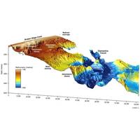
Unique Seafloor Data Provides Insight to Scientific Communities
The release of bathymetry data by Geoscience Australia has revealed seafloor maps with a resolution 15 times higher than those previously produced using satellite data. The bathymetric survey, conducted by Fugro during Phase One of the search for missing flight MH370, has provided a detailed map of the seafloor topography in the search area. Following the disappearance in March 2014 of the Malaysia Airlines flight, the southern Indian Ocean search, led by the Australian Transport Safety Bureau (ATSB), was acknowledged as one of the largest marine surveys ever conducted. Geoscience Australia supported
OI 2016 Preview: Hydrography, Geophysics & Geotechnics
drilling and sampling technology – performance and benefits of an automated system’. Following a short break for visiting the exhibition and networking, the conference will reconvene for a three-presentation session. The first will be by Andy Cowland, Geophysical Consultant, Fugro Survey Limited talking about ‘Seismic renaissance – A revitalized seismic service providing higher quality and reduced cost’. His presentation will be followed by ‘Hybrid data driven model based 3D de-multiple of 2D marine seismic data using swath bathymetry or side-scan sonar
Total Deploy LBL Network in Record Time
as we only had to use one vessel and make one trip out to the field. In addition, our innovative spreader bar meant we could deploy five frames in one sequence, thereby speeding up overall frame and Compatt deployment.” Echoing that positive sentiment, Steven Tonneman, Project Co-ordinator at Fugro Survey B.V. said, “The use of Technip’s two work-class ROVs operating concurrently in the field meant that we could simultaneously deploy, calibrate and move Compatts on the fly. Starfix.Acoustics, a Fugro specific variant of Fusion 6G, batched simultaneous baseline collection feature, allowed
Fugro's Survey Vessel to Search for Malaysia 370
The Australian Transport Safety Bureau (ATSB) has awarded Fugro a contract that will see the deployment of its specialist vessel, equipment and expertise in the underwater search for the missing Malaysia Airlines flight 370 (MH370). Using its advanced survey vessel, the Fugro Equator, fitted with state-of-the art multibeam echosounder equipment, Fugro will conduct a bathymetric survey of the search area. The seabed data obtained will assist in the production of maps of the seabed offshore Western Australia. This area is relatively uncharted and the maps will assist in planning subsequent
Improving Monopile Installations with Fugro’s InclinoCam
development of Fugro’s newly launched InclinoCam, which is featured on Fugro’s stand (30A100) at EWEA Offshore 2013. “The need to measure verticality of wind turbines starts with the foundation,” explained Dieuwertje Smallenburg, Positioning & Remote Services Manager at Fugro Survey BV. “Most offshore wind turbines are founded on monopiles that typically measure 70 meters in length with a diameter of 6.5 meters weighing 850 metric tons. These monopiles are driven into the seafloor using a hydraulic hammer, a process which can take several hours, so verticality is a
Oceanology International China Program Released
Mapping System for Quantitative Identification of Aquatic Macrophytes, Substrate Composition, and Shallow Water Bathymetric Surveying’ (Eric Munday, BioSonics Inc). After the lunch break the conference looks at: ‘AUV Expanding Dynamic in Geophysics Survey’ (Kelvin Chow, Fugro Survey Pte Ltd); ‘Seeing Through the Environment to Achieve Results’’ (Blair Cunningham, Coda Octopus Group, Inc); and ‘The Role of AUV Mounted Sonar in Pipeline Inspection and Other Hydrographic Survey Projects’ (Matthew Holland, Caris); and ‘The Course and Prospect