NOAA Awards $16.8 Million for Research in the Gulf of Mexico
support tools that prioritize locations for restoration and protection of snook and tarpon habitat as well as using vulnerability index, map-based modeling and monitoring of previous restoration of juvenile sportfish.Project Title: Protecting Texas Coastlines from Potential Oil Spills in Galveston Bay using Drone Surveys and Maps of a New Response Effectiveness IndexLead Institution: Texas A&M University in Corpus ChristiAward Amount: $1,026,368Project Description: The project team will use drone observations and NOAA forecasts to develop technology that seeks to improve manager response
UH Aims to Develop Subsea Pipeline Inspection Autonomous Robot
, we can dramatically reduce the cost and risk of these important subsea inspections which will lead to safer operations of offshore oil and gas pipelines as less intervention from human divers will be needed,” said Chen, noting that a prototype of the ROV has been tested in his lab and in Galveston Bay. The experiments demonstrated the feasibility of the proposed approach for inspecting the looseness of subsea bolted connections. Preliminary studies were funded by UH’s Subsea Systems Institute.The UH researchers are collaborating with Oceaneering, and Chevron will evaluate the technology&
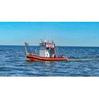
Unmanned Vessel Launched to Survey Western Galveston Bay
An unmanned vessel is now surveying more than 3,500 nautical miles of the Western Galveston Bay, near the Houston Ship Channel.DEA Marine Services, a division of David Evans and Associates, Inc. (DEA), in Vancouver, Wash., equipped its survey boat Sigsbee with a Sea Machines Robotics SM300 autonomous-command and remote-helm control system to fulfill a National Oceanic and Atmospheric Administration (NOAA) contract.Sigsbee, which is serving as an autonomous daughter craft for the project, is effectively doubling coverage by operating without an onboard crew, while collaboratively following another
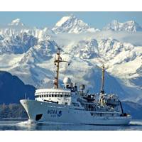
NOAA Releases 2018 Hydrographic Survey Plans
. Louisiana Coast – This survey project addresses concerns of migrating shoals and exposed hazards in the vicinity of the Atchafalaya River Delta and Port of Morgan City. Approaches to Houston, Texas – The current chart coverage of the area between Galveston Bay and Sabine Bank Channels shows numerous reported wrecks and obstructions. This survey will identify changes to the bathymetry and resolve position uncertainty in known hazards. Florida Keys National Marine Sanctuary, Fla. – This survey project provides updates to nautical
Gulf Oil Spill Restoration Projects Proposed
District ($136,700) Bike and Pedestrian Use Enhancements at Davis Bayou, Gulf Islands National Seashore – Mississippi District ($6,967,000) Restoring Living Shorelines and Reefs in Mississippi Estuaries – coastal Mississippi ($30,000,000) Texas Bird Rookery Islands– Galveston Bay and East Matagorda Bay, Texas ($20,603,770) Sea Turtle Early Restoration – Gulf of Mexico ($45,000,000) Pelagic Longline Bycatch Reduction – Gulf of Mexico ($20,000,000) It is anticipated that these projects will be included in a draft Phase IV Early Restoration
NOAA: US to See More Floods from Sea Level Rise
; Washington, D.C.; Norfolk, Virginia; and Wilmington, North Carolina; all along the Mid-Atlantic coast, will soon make, or are already being forced to make, decisions on how to mitigate these nuisance floods earlier than planned. In the Gulf, NOAA forecasts earlier than anticipated floods for Galveston Bay and Port Isabel, Texas. Along the Pacific coast the earlier impacts will be most visible in the San Diego/La Jolla and San Francisco Bay areas. Mitigation decisions could range from retreating further inland to coastal fortification or to a combination of “green” infrastructure
MTR 100: Texas A&M University at Galveston
including the Wetlands Center, Seafood Safety Lab, Sea Life Center Research Lab, Center for Texas Beaches and Shores and the Laboratory for Oceanographic Environmental Research. Campus waterfront operations include a fleet of floating classrooms and laboratories with immediate access to the ocean and Galveston Bay. (As published in the July/Aug 2014 edition of Marine Technology Reporter - http://www.marinetechnologynews.com/Magazine
NOAA Begins Hydrographic Survey Season
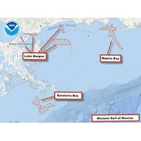
in San Francisco Bay and will later survey two anchorages near Benicia, Calif., to chart a shoal that has migrated toward the federal channel. Hydrographic surveys are always in high demand in the Gulf of Mexico. This year, NRT4 is responding to requests by pilots and port authorities to survey Galveston Bay and its vicinity. A NOAA contractor will survey in Louisiana, offshore of Barataria Bay, to acquire the data necessary to establish turnoffs and turning basins for large vessels. A contractor will also survey the approaches to Lake Borgne/Lake Ponchartrain in Louisiana, where some chart data
$790,000 Grant Funds HRI Research of Sea Level Rise
of developing new approaches. "HRI has already conducted sea level rise modeling for Galveston, Mustang, and South Padre Islands, and we recently completed a project identifying potential changes caused by sea level rise in ecosystem services values provided by marsh habitats in the Galveston Bay region," Gibeaut said. "This project will use some of the same basic approaches, but will be more extensive in area and analyses." The HRI assessment will involve projecting the geographic changes that sea level rise is expected to cause, the economic impact on the natural and