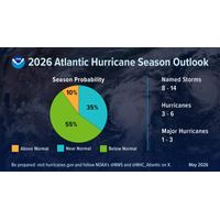
US Scientists Forecast Below-Normal Atlantic Hurricane Season
U.S. government scientists said on Thursday they expect a below-normal Atlantic tropical storm season in 2026, likely producing one to three major hurricanes with sustained winds of at least 111 miles per hour (179 kph).Officials from the National Oceanic and Atmospheric Administration unveiled the agency’s outlook for the season, which begins on June 1 and runs through November 30.They predicted eight to 14 named tropical storms with winds of at least 39 mph, from which three to six hurricanes with winds of at least 74 mph will likely form."Don't let words like below-normal change the

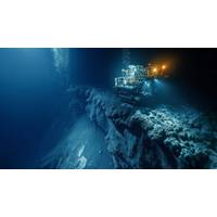
TMC Seabed Mining Application Meets US Federal Requirements
exploration and commercial recovery to be fully compliant with federal requirements, marking a key step toward potential approval.The company said it expects the regulatory process, including environmental review, to conclude by the end of first-quarter 2027.The National Oceanic and Atmospheric Administration determined that the application submitted by its U.S. unit meets all requirements under the Deep Seabed Hard Mineral Resources Act, TMC said.The decision comes as President Donald Trump's administrationencourages U.S. exploration of the deep sea by
Ocean Minerals Are Becoming a Real US Opportunity
;s Critical Minerals List.Unlike traditional government stockpiles, Project Vault is demand-led: manufacturers identify which materials they need, at what volumes, and make long-term financial commitments to ensure availability during supply disruptions.On the regulatory side, the National Oceanic and Atmospheric Administration (NOAA) recently finalized revisions to its regulations under the Deep Seabed Hard Mineral Resources Act, creating a consolidated application process for exploration licenses and commercial recovery permits. The updated framework streamlines a regulatory structure to reflect scientific
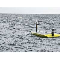
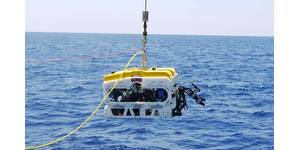
A Breath of Fresh Air: USVs Map Hypoxia in the Gulf
, often collected from extreme environments or over lengthy periods of time. The University of Southern Mississippi (USM), with the help of SeaTrac Systems, has turned to autonomous solutions while conducting hypoxia research in the Gulf of Mexico.The partnership, which includes the National Oceanic and Atmospheric Administration (NOAA), maps potential hypoxia in the Gulf and how it impacts local fisheries and fish populations. Hypoxic zones, also known as dead zones, are areas of water in which oxygen levels are decreased due to nutrient pollution, often significantly impacting aquatic life. The collaboration

Advanced Navigation Raises $110M Series C to Support Increased PNT Technology Demand
software with high-precision hardware to help systems conquer the extremes across sea, land, air and space.” This “Hard Tech” approach to navigation has made the company a partner to the world’s largest defense and technology giants, including Anduril, National Oceanic and Atmospheric Administration (NOAA), Hanwha, BHP, Rheinmetall and Intuitive Machines. Following a year of triple-digit growth, the company is accelerating its global expansion, scaling its deep tech operational and engineering presence across the U.S. and European markets.Software-Defined Navigation for
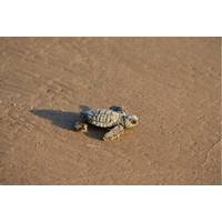
US Panel Could Scrap Endangered Species Protections for Gulf of America
Trump ordered the committee to meet at least quarterly.The committee has six federal members: the Secretaries of Interior, Agriculture and the Army, the chairman of the Council of Economic Advisers, the administrator of the Environmental Protection Agency and the administrator of the National Oceanic and Atmospheric Administration.Endangered and threatened species in the Gulf of Mexico include whales, sea turtles and corals.The endangered Rice's whale has been the subject of litigation over oil and gas exploration in the Gulf. A federal environmental analysis last year found that vessel strikes related

American Pilots’ Association Supports NOAA's Move to Adapt North Atlantic Right Whale Vessel Speed Rule
The American Pilots’ Association (APA) applauds the March 4, 2026 announcement by the National Oceanic and Atmospheric Administration (NOAA) that, as part of ongoing efforts to evaluate and improve regulations, it is publishing an advance notice of proposed rulemaking (ANPRM) to consider deregulatory action to modify and modernize the North Atlantic Right Whale Vessel Speed Rule (NARW VSR). In August 2022, NOAA proposed amendments to the current NARW VSR, which met immediate backlash from Congress and key parts of the maritime sector, including ports, merchant shipping, pilots, commercial/sp
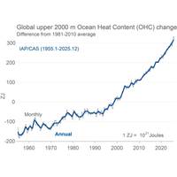
Climate Change: A Decade After the Paris Agreement
tying with 2023 as one of the warmest years ever measured.The WMO's consolidated dataset places 2025 at 1.44°C above pre‑industrial levels, ranking it among the top-three warmest years over the 176 years of recorded temperatures.ARCTIC: RAPID COLLAPSE OF SEA ICEThe U.S. National Oceanic and Atmospheric Administration’s (NOAA) 2025 Arctic Report Card confirmed that October 2024–September 2025 was the warmest period since 1900, and the region continues to warm more than twice as fast as the global average.Sea‑ice extent reached the lowest winter maximum ever recorded in March 2025

DOLGO Launches AI Platform to Document, Share Workforce Knowledge
;the vanishing aging workforce. As a measure of the scale of the problem in the United States today, the average age of shipyard workers is 55-years-old. This is against a backdrop of shipbuilding demand being set to double over the next decade.DOLGO has been spun out of the National Oceanic and Atmospheric Administration (NOAA) Ocean Enterprise Accelerator and has built its AI platform and undertaken testing with the University of South Florida’s marine science lab. The software enables workers to share knowledge, allowing companies to retain skills for new and existing engineers.Wazenn