Entanglement Acquires Applied Ocean Sciences
complex sensing, modeling, and decision-making challenges across ocean, atmosphere, and increasingly space-enabled Earth observation systems.AOS has a long history of work with government agencies and research institutions, including the World Wildlife Fund, U.S. Navy, DARPA, NOAA, the U.S. Naval Research Laboratory, and the Office of Naval Research. Its scientific collaborations also include globally respected institutions such as the Woods Hole Oceanographic Institution, the Scripps Institution of Oceanography, and the Walter Munk Foundation for the Ocean.“This is a defining moment for Entanglement

Travis Derrington Joins BIRNS as Project Manager
Chief (E-8). During his successful military career, he served on the ballistic missile submarine USS Ohio (SSGN 726), at Seal Delivery Vehicle Team 1 working with the Advanced Seal Delivery System and Dry Deck Shelters and as the Mechanical Division Leading Chief Petty Officer for the U.S. Naval Research Laboratory.After years of spearheading projects during complex missions at sea, Derrington is comfortable now leveraging his discipline, teamwork and strategic planning skills in the civilian sector. “It’s been an exciting and welcome challenge leading projects with the excellent team
MBARI Research Supports Cryospheric Science
in the Arctic. This summer, MBARI researchers will return to the Canadian Beaufort Sea to continue this work.MBARI’s collaborators on this body of work include researchers at the Geological Survey of Canada, Fisheries and Oceans Canada, the Korean Polar Research Institute, and the US Naval Research Laboratory.MBARI is part of the Southern Ocean Carbon and Climate Observations and Modeling (SOCCOM) project, an international, multi-institutional effort to help researchers better understand the Southern Ocean, one of the most challenging regions to study on the planet.SOCCOM uses robotic BGC-Argo
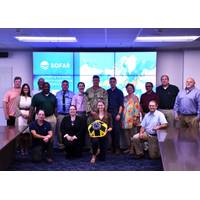
US Navy Taps Into Sofar Ocean's Data Buoy Network for Weather Forecasting
to ensemble-based data assimilation and coupled modeling; and its DaaS products. Representatives from Naval Oceanography’s subordinate commands and partners — the Naval Oceanographic Office (NAVOCEANO), the Fleet Numerical Meteorology and Oceanography Center (FNMOC), and the Naval Research Laboratory (NRL) — also attended the event. The groups provided critical insights about hardware deployment capabilities, data needs, and the Verification and Validation (V&V) process. NAVOCEANO, FNMOC, and NRL will each play a central role in the identification of use cases for Sofar&rsquo
Getting to the Bottom of the Navies' Mine Warfare Challenges
cycle required to act on that specific threat. That presupposes that the underwater vehicle can communicate with a surface buoy or surface and send a message by satellite or other means; but, if that’s the case, a launch and recover cycle can be avoided or delayed.The Naval Research Laboratory (NRL) is a scientific and engineering command dedicated to research that drives innovative advances for the U.S. Navy and Marine Corps from the seafloor to space and in the information domain. NRL is located in Washington, D.C. with major field sites in Stennis Space Center, Mississippi
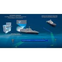
Subsea Defense: Navy Deepens Commitment to Underwater Vehicles
;The NRDE spent years developing prototype sensors and algorithms that were tested in relevant environments to perfect the technology for transition to a program of record,” Taylor said.“Low-frequency broadband (LFBB) is our term for a technology area that we developed here at the Naval Research Laboratory (NRL) that exploits the structural acoustics involved with underwater sonar,” said Dr. Brian Houston, Acoustics Division superintendent at NRL. “When you transmit sound, the acoustic return is very different depending on the physical object that is reflecting that acoustic
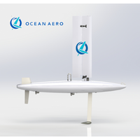
Ocean Aero to Supply Vehicles for Homeland Security
research, evaluation and testing program.Ocean Aero will deliver a mix of its Navigator and Discovery models and working closely with DHS and other program participants—the U.S. Coast Guard (USCG), U.S. Customs and Border Protection (CBP), The University of Southern Mississippi, the U.S. Naval Research Laboratory (NRL), and Cherokee Nation Strategic Programs, LLC. Ocean Aero’s vehicles will be deployed in a wide range of ocean environments providing a platform for the integration, testing, and evaluation of a variety of advanced sensors.“This is a strategic agreement, and we’re
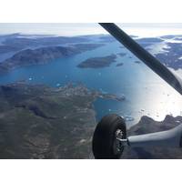
Airborne Hyperspectral Survey, Mineral Mapping in Greenland
Resources. The first phase of the project consisted of collecting airborne and land-based data. Field operations were conducted from late July to early August 2019 by project partners including the Greenland Ministry of Mineral Resources, the U.S. Department of State, the U.S. Naval Research Laboratory, the U.S. Geological Survey, and Asiaq - Greenland Survey. The next phase of the project will include processing and analysis of the hyperspectral data. ASL's team of researchers, analysts and geologists will generate a range of information products and maps in collaboration with
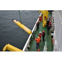
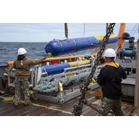
USN: Knifefish UUV Program Achieves Milestone
Package and will reduce risk to Navy personnel and equipment.The Knifefish system, which consists of two unmanned undersea vehicles along with support systems and equipment, uses cutting-edge low-frequency broadband sonar and automated target recognition software technology developed by the Naval Research Laboratory and successfully transitioned to industry. It acts as an off-board sensor while the host ship stays outside the mine field boundaries.Knifefish’s common open systems architecture design and modularity allow for platform flexibility and quick reconfiguration of the mission package to