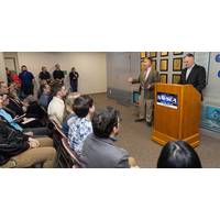
NUWC Division Newport Awards Recognize 12 Patent Inventors, Published Authors
and the creation of a one-of-a-kind challenge coin designed by paralegal Lauren Paquette and members of the graphic design team.One side of the coin features a patent and sketch of the first marine chronometer, invented by John Harrison in 1761. Kasischke said the chronometer is a “fundamental navigation tool” that helps ships determine positioning.Along the edge is the phrase “In promotion of the progress of science and useful arts,” which is part of the Intellectual Property Clause in the U.S. Constitution, and “Together in Innovation,” the motto of the newly formed
FarSounder Receives 8th Patent
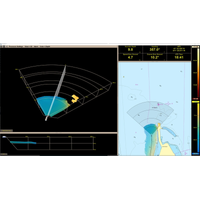
US patent expands the company’s patent portfolio for its unique sonar system and its 3D processing.The invention provides a sonar system that includes a forward-looking sonar device that operates in an integrated fashion with one or more other sonar devices so that a boater can have a reliable navigation tool. The forward looking sonar can include a transducer array that takes a three-dimensional acoustic reading of the objects and seafloor ahead. The electronics that process the acoustic data can also process data from down-looking sonar, side-scanning sonar, or both and can integrate the information
FarSounder Signs on NAVSEA UUV Project
as the maritime world begins to enter this new territory of unmanned vessels,” said Cheryl M. Zimmerman, FarSounder CEO. “Our team is proud to contribute to this research and excited to do our part in keeping these vessels safe.”The compact and lightweight Argos 350 is a navigation tool for situational awareness for USV/UUVs. Being without a crew, they have an even higher risk of collision due to limitations with traditional navigation methods and technologies. This 3D FLS system allows the vessel to know in real-time what is ahead under the water before it's too late
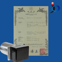
FarSounder Acquires Japanese Patent
Office, one of the largest in the world. This patent relates to their invention of integrated sonar devices and methods and is FarSounder's first issued in Japan."Since 2004, FarSounder has delivered reliable navigation to vessel operators. With this invention, we expand upon our innovative navigation tool. This technology will help assure our IP as we expand our product lines into new applications and markets." Says Matthew Zimmerman, VP of Engineering at FarSounder and one of our inventors.This exciting invention generally relates to sonar devices that integrate forward-looking sensors
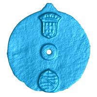
Earliest Known Marine Navigation Tool Found
State-of-the-art laser scanning technology has helped researchers to confirm that an artifact recovered from the wreck of a sunken 15th century ship in the Indian Ocean is the earliest known marine navigation tool. When the Blue Water Recovery team found the object in 2014, they believed it was an astrolabe used by mariners to measure the altitude of the sun during voyages, but they were not certain as there were no visible navigational markings. The team approached Professor Williams, who conducts high-tech scanning analyses in his laboratory at WMG University of Warwick in the U.K.

Ove Bråthen strengthens Scandinavian sales team at MARIS
; Mr Bråthen takes over from Line T. Øverland, who has accepted a challenging position with Det norske Veritas (DnV). He said: “I look forward to serving MARIS customers in such a way that they can focus on safe vessel operation and have full confidence in the reliability of their navigation tool, MARIS ECDIS.” Steinar Gundersen, Deputy Chief Executive (Corporate) MARIS AS added: “Ove Bråthen brings a wealth of industry experience to MARIS and his unrivalled knowledge and commitment will prove invaluable as the company continues to grow.”


