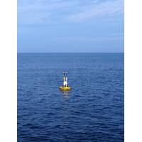
Atlantic Shores to Deploy Research Buoys at U.S. Offshore Wind Lease Area
for Atlantic Shores as the company continues to study its Lease Area for the eventual build-out of over 3 gigawatts of offshore wind. While progressing its portfolio of projects, the developer continues to work with state universities conducting atmospheric and migration research off the New Jersey coast. Last year, Atlantic Shores and Rutgers University Center for Ocean Observing Leadership (RUCOOL) collaborated on the installation of a wind LiDAR (light detection and ranging) instrument alongside the causeway leading to the Rutgers University Marine Field Station in Tuckerton, New Jersey
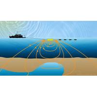
Atlantic Shores Launches Ocean Survey Ops
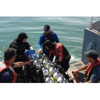
, a 50/50 partnership between Shell New Energies US LLC and EDF Renewables North America, announced the launch of ocean survey operations today within the Atlantic Shores lease area, in order to inform future turbine development.Survey operations encompass 183,000 acres located 8-20 miles off the New Jersey coast between Barnegat Light and Sea Isle City and are expected to conclude by the end of October, weather permitting.The survey vessel Geosea will be utilized to characterize the seabed, collect samples and determine placement of data collection buoys, which will be deployed later this year to help
Fugro Wins Work at US Offshore Wind Sites
;rsted to undertake geotechnical investigations at two large-scale offshore wind development sites in the U.S. Ørsted is pursuing the development of the two new projects: Bay State Wind, located 15 miles off the coast of Martha’s Vineyard, Mass. and Ocean Wind, 10 miles off the New Jersey coast – to bring wind energy to American consumers and businesses. The marine site characterization at both sites involves specialized sampling and in situ testing which Fugro will perform from its DP2 geotechnical drillship, Fugro Explorer. For laboratory testing and reporting services
Fresh Water below the Seafloor?
depending on the conductivity of the material they are passing through. Since fresh water is a poor conductor of electrical currents, CSEM can distinguish it from salt water and other types of fluids. Using the technique, Evans was able to find signals of a layer of fresh water off the New Jersey coast in 2015—“at similar depths to where fresh water was originally discovered through drilling,” he said. Repurposing the CSEM technique for freshwater detection could be a significant step forward in the search for offshore fresh water, said Mark Person. &ldquo
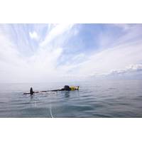
'PowerBuoy' Deployed off New Jersey Coast
Press Release - Ocean Power Technologies, Inc. (OPT) has deployed its APB350 A1 PowerBuoy approximately 14 miles northeast of Atlantic City, N.J. Real-time performance and weather data will be collected and transmitted to OPT's monitoring and analysis center at its corporate headquarters in Pennington, N.J. According to OPT, the APB350 A1 contains an improved Power Takeoff (PTO) system compared to the APB350 that was deployed in 2011 in connection with the U.S. Navy's Littoral Expeditionary Autonomous PowerBuoy (LEAP) Program and then redeployed in 2013 in conjunction with the U.S. Department of
Disasters at Sea & Their Impact on Shipping Regulation
primary safety book from which most other policies and regulations sprang, SOLAS is updated on a regular basis and is considered the safety bible for the maritime industries. (See related story page 43) The Titanic may have gotten the ball rolling, but the 1934 sinking of the Morro Castle off the New Jersey coast, which left 126 dead, also left quite a safety legacy in its wake. The ship, which went up in flames, not only led to new fire suppression, protection and control regulations and equipment requirements, it served as the impetus for both the U.S. Merchant Marine Act of 1936, which created the
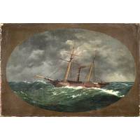
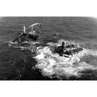
NOAA Finds Lost 19th Century U.S. Coast Survey Steamer
Bay and the Florida Keys ‒ in the decade before the Civil War. It also conducted early work plotting the movement of the Gulf Stream along the Atlantic Coast. Twenty sailors died when the Walker sank in rough seas in the early morning hours of June 21, 1860, 10 miles off Absecon Inlet on the New Jersey coast. The crew had finished its latest surveys in the Gulf of Mexico and was sailing to New York when the Walker was hit by a commercial schooner off New Jersey. The side-wheel steamer, carrying 66 crewmembers, sank within 30 minutes. The sinking was the largest single loss of life in the history
Subsea Wreck Identifed Off NJ Coast 153 Years On
maritime archaeologists have identified the wreck of the ship 'Robert J. Walker', a steamer that served in the U.S. Coast Survey, a predecessor agency of NOAA. Twenty sailors died when the Walker sank in rough seas in the early morning hours of June 21, 1860, ten miles off Absecon Inlet on the New Jersey coast. The crew had finished its latest surveys in the Gulf of Mexico and was sailing to New York when the Walker was hit by a commercial schooner off New Jersey. The side-wheel steamer, carrying 66 crewmembers, sank within 30 minutes. The sinking was the largest single loss of life in the history
Post Sandy Remap New Jersey Project
Navionics has partnered with the Marine Trades Association of New Jersey, West Marine and other local businesses to organize the Remap New Jersey/Sandy Project. The Remap New Jersey/ Sandy Project is a three-day event to be held July 19-21 to remap affected areas along the New Jersey coast. As part of this effort, Navionics will donate $1 per mile of sonar logs to benefit the Marine Trades Association of New Jersey Recovery and Relief Fund. How to help Hummingbird and Garmin users can record sonar logs, and then upload them to the Navionics webstore. Updated charts, reflecting everyone's