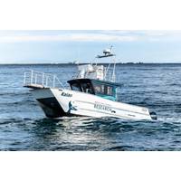
Brix Marine Delivers Research Vessel for Pacific Whale Foundation in Hawaii
the boat. Now having 200 hours on it, I can confidently say that it’s custom-built to fit our needs, and it has worked out incredibly well, making research a lot easier.”To facilitate marine research and observation, the vessel is equipped with cutting-edge equipment, including a Garmin radar system as well as a viewing platform, a drone launching/landing platform and a bow pulpit. Kaiao can accommodate up to 8 crew members on board.PWF will use Kaiao for many vital initiatives, including marine research, wildlife observation, educational tours and conservation efforts, amplifying their efforts
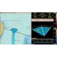
FarSounder, Navtor Partner
;s trusted e-Navigation ecosystem. The cloud-based data distribution keeps everything up to date, with the latest charts and publications delivered seamlessly to the vessel. For vessels with an ECDIS installed, there is now the option to have matching map displays on both their ECDIS and FarSounder radar system," said Bjørn Kristian Sæstad, CBDO OEM/SDK at Navtor.“In this release, users will not only have support for NAVTOR ENC chart data included, but they will also be able to bring up Automatic Identification System (AIS) targets and Automatic Radar Plotting Aid (ARPA) targets
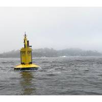
OPT's PowerBuoy Deployed Offshore Chile
Center (MERIC) Project, a hub for innovation in marine energy in Chile and internationally, OPT said Thursday.An associated shore station was developed and supplied by OPT and assembled and installed by Chile-based Salmoboats. OPT also worked with Italy-based iSat to provide a shore-based wave radar system installed by local contractor BZ Naval.The autonomous offshore platform will eventually power a suite of oceanographic sensors and transmit real-time environmental data to a dedicated shore station studying the potential effect of marine energy under real-world sea conditions with minimal carbon
UK Gov't Sets Aside $5M for Tech That Can Mitigate Offshore Wind Farms Impact on Radar Systems
with the Royal Air Force (RAF), the Defence Science and Technology Laboratory (Dstl), and DASA.In the first phase DASA awarded contracts to Thales, QinetiQ, Saab, TWI and Plextek DTS to fast-track their ideas for technologies that can mitigate the impact of wind farms on the UK’s air defense radar system.Suppliers can take part in Phase 2 of the competition if they were not involved in Phase 1.
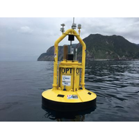
OPT Announces PB3 PowerBuoy Contracts
.The second contract with Enel Green Power Chile Limitada S.A., a subsidiary of Enel Chile, calls for OPT to develop and supply a state-of-the-art, turn-key integrated Open Sea Lab (OSL). The OSL encompasses a sensor suite to be powered by the PB3 PowerBuoy, as well as an integrated shore-based wave radar system. The sensor suite will comprise an Acoustic Doppler Current Profiler (ADCP), a device which is used to measure water current velocities over a depth range, water sensors, and mooring load sensors. The design and buildout of the OSL will be spearheaded by OPT’s Innovation and Support Services
Atlantic Canada Profiles: Rutter
; The world of onboard navigation systems is always changing, and as such, existence of convenient user-interfaces and powerful navigation capabilities are in constant evolution. Contributing to this evolution is Rutter Inc., which in the first quarter of 2017 is releasing an update to its flagship radar system, the sigma S6 Ice Navigator, adding Advanced Ice Analysis to the system. In addition, Rutter will release the new sigma S6 Ice Defense system, an ice radar system aimed at users for whom ice management is a serious operational and safety concern when working in areas with sea ice and icebergs
New Satellite Technology Boosts Glacier Research
4, 2016. Scientists from the Alfred Wegener Institute are developing with experts from the German Aerospace Centre (DLR) a new satellite measurement method for the observation from space of the large ice masses of Greenland and the Antarctic. "Tandem L" is the name of a new satellite radar system, Which launched in the year 2022 Could Provide urgently needed data Concerning the shrinkage of the ice sheets in Both hemispheres. Concerning the construction of the radar and the launch of the satellite mission of the same name, the Science Council is to advise the Federal Ministry of Education
Station-Keeping In Ice
to the Arctic in the early ‘90s, the statistics said there was a very small chance that there would be a vast ice floe,” recalls David Millan, who was working for NORDCO of St. John’s as the Engineering Project Lead. His mission was to collect and analyze data on a brand new digital radar system on board a 1,000-foot long icebreaking cargo ship (now MV Arctic). He climbed aboard in Antwerp and was heading for Nanisivik on Baffin Island. While travelling at 6 knots, the ship came to an abrupt halt. It had hit a massive ice floe. “It practically threw people off their feet,&rdquo
Port of Prince Rupert Adds Shore-based Radar
through our port, and further safeguards the environment and mariners of British Columbia’s north coast.” The $5 million project was jointly funded by Western Economic Diversification Canada and the Prince Rupert Port Authority, with ongoing operation and maintenance of the radar system provided by the Canadian Coast Guard (Fisheries and Oceans Canada). The system improves the capability of the organizations responsible for vessel monitoring and management to prevent vessel incidents in the harbor, a monitoring and response regime that works around the clock. &ldquo