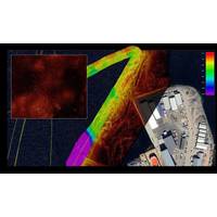
China Mapping Ocean Floor Ready for Submarine Warfare
ranges and sits astride the approach to the strategically essential Malacca Strait, through which much of China's oil supply passes.Ocean University and the Institute of Oceanology, which is part of the Chinese Academy of Sciences, have said the wider network of sensors now provides China with real-time data about water conditions and subsea movements.Some naval-warfare experts expressed caution about that claim, given technical challenges with real-time communication of data from underwater. But even delayed data is valuable, Parker said, as it could help China detect U.S. submarine operations
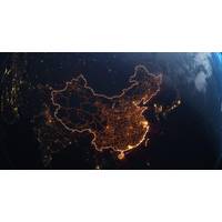
China Maps Ocean Floor as It Builds Submarine Warfare Capability
ranges and sits astride the approach to the strategically essential Malacca Strait, through which much of China's oil supply passes.Ocean University and the Institute of Oceanology, which is part of the Chinese Academy of Sciences, have said the wider network of sensors now provides China with real-time data about water conditions and subsea movements.Some naval-warfare experts expressed caution about that claim, given technical challenges with real-time communication of data from underwater. But even delayed data is valuable, Parker said, as it could help China detect U.S. submarine operations

Bridging the Data Divide: How AI Will Rewire Maritime, Port Ops
the company’s core solution, ForgeTrack, comes into play.Rather than replacing existing systems, ForgeTrack acts as a connective layer, what Ponce calls a “universal translator” for global trade. It ingests legacy data formats, including traditional EDI messages, and converts them into real-time, usable information streams that can be shared across the ecosystem.“Think of it like this,” he said. “You have the letter, but it’s written in a language your partner can’t read. What we do is translate it, in real time, into whatever format they need, and then
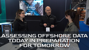
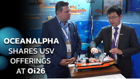
Oceanology International 2026 Brings Ashore New COAST Focus
event. In response to global coastal challenges, the inaugural COAST conference track will focus on innovation and solutions in topics like coastal zone management, protecting the environment in coastal waters, coastal resilience, ports and terminals, and coastal infrastructure protection.Additionally, as real-time data and predictive modeling prove increasingly vital for coastal planning and disaster response, Oi will offer opportunities to explore integrated monitoring platforms and early warning systems. The balance between economic activity and environmental protection, another critical intersection
Kongsberg Discovery Launches HISAS2020 Synthetic Aperture Sonar
as part of integrated payloads on Kongsberg Discovery’s HUGIN AUV family, HISAS can now be implemented across any platform – including all relevant AUVs, USVs, ROVs and towed assets – delivering clear, centimeter-level resolution, robust system design for long-term reliability, and real-time data processing. The solution, suitable for an array of defence, energy and ocean science applications, will be officially showcased at Oceanology International in London in March.Speed and precisionHISAS2020 operates in the 120–210 kHz frequency range, delivering ultra-high-resolution
Underwater acoustic monitoring: safeguarding marine life in harbour expansion projects
, enabling port authorities and construction firms to mitigate the impact of noise on marine life while ensuring regulatory compliance.This article explores the critical role of underwater acoustic monitoring in harbor expansion projects, examining its technological foundations, regulatory frameworks, and real-world applications through case studies in Europe and the Caribbean.The environmental impact of underwater noise in port constructionMarine construction activities produce three primary types of underwater noise, each with distinct characteristics and ecological consequences. The first is impulsive
MRECo Develops Two Marine Energy Test Sites in Massachusetts
sites in Massachusetts: the Bourne Tidal Test Site (BTTS) in the Cape Cod Canal and the Cuttyhunk Test Range (CTR) off Cuttyhunk Island.Together, these sites give innovators a safe, affordable, and permitted way to deploy new ocean technologies in the water, bridging the gap between lab experiments and real-world use.The Bourne Tidal Test Site, located in the Cape Cod Canal, is a platform built specifically for testing tidal energy devices and marine sensors in fast-moving water. The site allows engineers and researchers to see how their technology performs in strong tidal currents, while still being
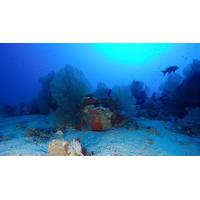
Robotics Essential to Coral Reef Preservation Efforts
explores the potential of AUVs for comprehensive coral reef monitoring, highlighting recent advances including combining passive acoustic mapping with visual habitat classification onboard AUVs to provide multi-modal coral reef surveys. Current AI and machine learning developments additionally enable real-time data analysis and improved imaging techniques.Developments in autonomous systems, including the integration of AUVs with autonomous surface vehicles offer exciting possibilities for multi-platform operations, they say, with recent technological advancements including centimeter-scale coral-monitoring
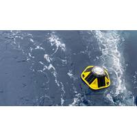
Australia Opens a Wave Data Portal
UWAResearch Fellow Marzieh Derkani and project lead at TIDE Dr Jeff Hansen with one of the drifting buoys. Source: UWAThey provide data crucial for forecasting wave and swell conditions, says Dr Jeff Hansen. “These new low-cost wave buoys now make it possible to collected detailed wave data, in real-time, from the middle of the ocean, where historically we haven’t had observations of waves. This allows us to compare and feed these data into wave forecasting models to improve their accuracy, something we’re working on with the Bureau of Meteorology.”Wave forecasting models lag