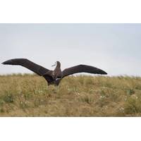
Study Identifies "Collision Map" For Birds, Boats to Support Conservation Efforts
oceanographic data. PML’s expertise in Earth observation was used to examine how physical ocean features shape these danger zones. These data were analyzed at two scales: seasonal patterns using long-term climate data, and finer monthly patterns using real-time ocean conditions.By combining satellite tracking data with ocean information, the team could better understand how ocean features affect the area. These features include:Thermal fronts (zones where warm and cold water meet)Turbulent mixing (churning water)Eddies (currents rotating across tens of kms)The analysis revealed that collision hotspots
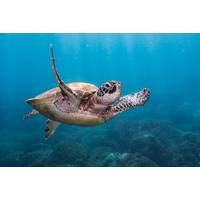
Marine Animals Travel at Depth that Minimizes Wave Formation
limitations.In this new study published in Proceedings of the National Academy of Sciences (PNAS) near surface swim depths were recorded to within 1.5 centimeters in little penguin and loggerhead turtles, along with motion data and video footage from animal borne cameras. This was compared with satellite tracking data for long-distance migrations in green turtles and data from other studies on penguins and whales.It was found that these animal swim at optimal depths predicted from physics when either commuting to a foraging patch in the wild or migrating over longer distances while not feeding.Swansea
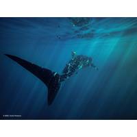
Whale Sharks Beware!
An international study has found whale sharks and ships are more likely to collide by the end of the century due to climate change.The researchers used global climate models and satellite-tracking data of 348 tagged whale sharks from 2005 to 2019 and combined it with shipping traffic models and habitat suitability estimates to predict the risk of interaction.Whale sharks are highly mobile marine megafauna that can travel hundreds or thousands of kilometers annually. The species are already vulnerable to collisions with ships due to their use of surface water and the high level of habitat overlap with
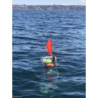
Lander Lab: Technologies, Strategies and Use of Ocean Landers
can choose from a suite of release mechanisms to suit the mission profile. On return to the surface, the vehicle becomes a spar buoy. It’s top most structure is raised out of the water, providing a line-of-sight to the ship for a radio and strobe light, or to the sky for a satellite tracking system. A flag is always a good thing, and reflective tape can help with a searchlight at night. We always add a tag for someone to contact the lander’s owner should it go AWOL. Davy Jones can be such a prankster.Figure 3. Then-and-Now. Munk/Snodgrass Deepsea
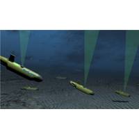
Sourcing Seismic with Subsea Swarms
lot less carbon emissions, which is important now.”Illingworth has a background in developing start-up technology companies. Born in the UK, he moved to Australia where he founded and sold computer software firm SmartTrack in the early 2000s. Illingworth went on to work in telecommunications, satellite tracking and then petrophysical data evaluation before co-founding Blue Ocean Monitoring, a Perth, Australia-based start-up, in 2014, with co-founder and chief technology officer Ben Hollings, whose background is in maritime robotics development. Blue Ocean Monitoring’s focus is using robotics
Israel Says It Tracked Down the Ship Linked to Recent Oil Spill
showed. It next reported its position with a destination of Mersin in Turkey on Feb. 3, showing a gap between Feb. 1 and 3.The vessel did not report any destinations in Syria, though it is also common for ships to conceal movements there.An international convention requires merchant ships to have a satellite tracking device on board when travelling at sea. But a ship's captain has the discretion to switch the transponder off under certain circumstances, enabling them to avoid detection.The Israeli environmental protection ministry said it had collected strong "circumstantial evidence" that
Tracking Ship Emissions from Space
A new ground-breaking study by University College London (UCL) Energy Institute, Imperial College and the University of Oxford shows how satellite tracking could be used to monitor compliance with the upcoming IMO 0.5% sulfur emission regulations and Emission Control Areas (ECA).Research conducted by their own researchers, UCL Energy and the University of Oxford and published today in Geophysical Research Letters, has unveiled discoveries that appear important on many levels for they describe the impact of shipping emissions on the climate: because fossil fuel emission particles from ships affect the
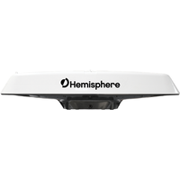
Multi-GNSS Vector Smart Antennas Launched
V133 all-in-one smart antennas with integrated Atlas L-band designed for professional and commercial marine applications. Powered by Hemisphere's Crescent Vector technology, the new V123 and V133 are multi-GNSS compass systems using GPS, GLONASS, BeiDou, Galileo, and QZSS for simultaneous satellite tracking to offer heading, position, heave, pitch, and roll. With support for NMEA 0183 and NMEA 2000, and continuing to offer ease of installation, these Vector models continue to offer the exceptional value and performance Hemisphere is known for. The V123 and V133 thrive in Radar/ARPA, AIS, ECDIS
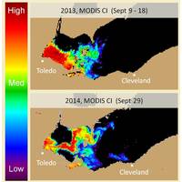
Severe Algal Bloom Predicted for Lake Erie
, field observations on water quality, algal biomass and toxicity will be collected by NOAA GLERL and CILER, the Ohio State University’s Sea Grant Program and Stone Laboratory, Heidelberg University, the University of Toledo, Ohio EPA, and LimnoTech. USGS will work with NASA in providing satellite tracking of the bloom as well. These results will provide valuable information to regional managers and assist NCCOS scientists in further refining the accuracy of this year’s forecast models. The Lake Erie forecast is part of a NOAA ecological forecasting initiative that aims to deliver