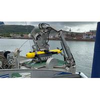
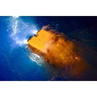
Kraken Demos KATFISH High Speed Towed SAS at Royal Navy WISEX
integrated to its Seagull 12-meter Uncrewed Surface Vessel (USV). The goal of the trials was to survey two distinct ranges with dimensions of 600 m x 4 nm where the RN placed several Mine Like Objects (MLO) to be searched for by WISEX attendees. The ranges were selected to replicate real world search areas of complex bathymetry and strong currents. During the trials, the Kraken KATFISH was launched, operated, and recovered in varying surface conditions including Sea State 4. Live, high resolution SAS data was wirelessly transmitted to a shore-based operators station over several kilometers
Getting to the Bottom of the Navies' Mine Warfare Challenges
accurately marked for further investigation, neutralization or avoidance. The vehicle may have to conduct prolonged and methodical search patterns, and that may require a vehicle with a lot of power and endurance, which translates to a lot of batteries, and thus a bigger vehicle for those larger search areas. The size of the vehicle also has bearing on the size of the sensor package, although sophisticated sensors are becoming smaller and smaller, and can also fit on smaller vehicles. Vehicles must be recovered and recharged or batteries swapped out. Some UUVs are fully flooded,
Tech File: Sonar Equipment Critical to Search and Recovery
operation and for the closure brought to those affected by the loss.Lt. Thomas Grady said “the side scan has been a great tool; it has allowed us to do our searches and only put our divers in the water if we see something that we want checked out. It certainly allows us to cover much wider search areas in substantially less time and reduces risk to our divers by only having them in the water when we have a specific area/target to confirm. The side scan has been a valuable additional resource for our team.”A few of the many teams using Fishers side scan sonars are Columbia County Sheriff&rsquo
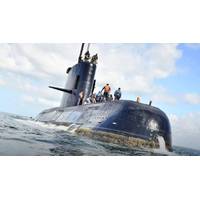
Ocean Infinity’s Hunt for the Submarine San Juan
itself in a number of international search efforts.Ocean Infinity committed to conduct the search operation for up to 60 days and to covers its cost, unless the submarine was found. It deployed its Seabed Constructor vessel with five Hugins. The initial 10-12 days covered three, what were thought key, search areas. But the submarine wasn’t found. “We went back and brought in more experts to think about what happened and expanded and expanded the search.”Ocean Infinity’s setup is geared to find things on the seabed, quickly. Its Hugins are capable of operating in water depths from
US Exits Search for ARA San Juan
for the still-missing Argentine submarine A.R.A. San Juan that vanished in the South Atlantic in mid November. The U.S. joined the Argentina-led multinational search efforts within 24 hours of learning of the missing submarine on November 17, and is now drawing down, having twice swept the search areas assigned by the Argentine Navy with advanced sensors. U.S. planning and analytical specialists will continue to support the efforts through data analysis. At its height, U.S. contributions to the search and rescue effort included more than 200 search and rescue personnel, four
MH370 Searchers Find Shipwreck
Operational Search team. The process is methodical, meticulous and it is designed to ensure that nothing is missed. In this case we planned to resurvey the contact in more detail when the opportunity arose.” Therefore Fugro Supporter was tasked to divert on its passage between two search areas and further investigate the contact. A high-resolution sonar scan was performed using the AUV. The high-resolution data revealed a large number of sonar contacts lying very close to the seafloor, at a depth of around 3,900 meters. The majority of the contacts were comparatively small &ndash
Divers Continue Hunt for AirAsia Black Boxes
the plane have been plucked from the surface of the waters off Borneo, but strong winds and high waves have been hampering divers' efforts to reach larger pieces of suspected wreckage detected by sonar on the sea floor. Weather agency officials warned on Thursday that although conditions at search areas had improved over the last two days, they were likely to worsen from Friday onwards. Indonesia AirAsia, 49 percent owned by the Malaysia-based AirAsia budget group, has come under pressure from the authorities in Jakarta since the crash. The transport ministry has suspended the
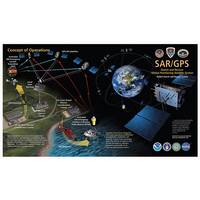
Search and Rescue Tech. Oceania
beams that sweep the darkness, he understands that what he is seeing is a large search area in the vicinity of his capsized vessel, now more than a mile away. At the command center, personnel are familiar with the science of drift, and another system is already collating this data. To calculate search areas in the complex currents of the Hawaiian Islands, watchstanders use the Search and Rescue Optimal Planning System (SAROPS), a software system that uses simulated particles generated by users in a graphical interface. These particles are then influenced by environmental data to provide information


