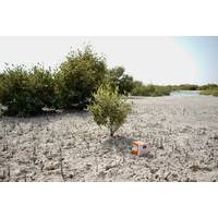
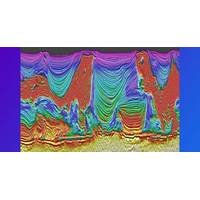
Sercel to Deliver WiNG 3C Nodes for Khushi Oilfield Seismic Survey
in Gujarat, western India, on behalf of Sun Petrochemicals Pvt. Ltd., an Indian oil and gas company. This project represents the first deployment of 3C MEMS nodal technology for a seismic survey in India.The WiNG 3C node acquires the comprehensive and high-definition seismic data for enhanced seismic imaging in complex geological environments. Leveraging QuietSeis MEMS 3C technology, the solution provides high-fidelity digital measurements that improve subsurface resolution, supporting accurate identification of deep exploration targets and effective reservoir monitoring.In addition, WiNG's
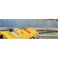
On-Demand Ocean Bottom Node: A New Era in Deepwater Seismic Monitoring
4D seismic surveillance, with fewer people and lower environmental impact. This milestone marks a step closer to a fundamental shift in deepwater reservoir management.The ChallengeBrazil’s pre-salt reservoirs lie in more than 2,000m water depth, plus another 3,000m beneath the seabed, making seismic imaging particularly challenging.Traditional seismic surveys using ocean bottom nodes (OBNs) provide high-quality seismic data, but are often expensive and logistically complex, involving the repeated deployment and recovery of nodes using remotely operated vehicles (ROVs).These factors can limit the
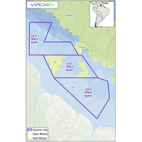
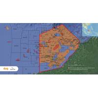
Viridien and BGP Win Guyana 3D Seismic Program
Ministry of Natural Resources of the Cooperative Republic of Guyana to launch a massive multi-client 3D seismic acquisition and imaging program across the shallow water acreage lots 2, 3 and 4, an area comprising approximately 25,000 square kilometers.New data will be acquired by BGP and high-end seismic imaging will be performed by Viridien, applying its industry-leading proprietary advanced workflows, including state-of-art shallow water demultiple and time-lag full-waveform inversion (TLFWI). The resulting new subsurface images, along with any potential future reimaging of existing seismic data,
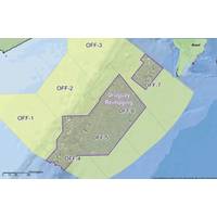
Viridien Launches Charrua 3D Seismic Survey Offshore Uruguay
Viridien has kicked off the Charrua 3D multi-client seismic survey offshore Uruguay, marking a new phase of exploration activity in the country’s offshore basins.Data acquisition will be carried out by the vessel BGP Prospector, with the company applying seismic imaging technologies including time-lag full-waveform inversion (TLFWI) to produce high-resolution subsurface images.The survey expands Viridien’s multi-client seismic data coverage and reflects growing industry interest in the southern Atlantic Margin, where offshore basins in Uruguay share geological similarities with Namibia&rsquo
Viridien Teams Up with NVIDIA to Accelerate Seismic Imaging Workflows
Viridien has entered into a collaboration with NVIDIA to advance high-performance computing (HPC) capabilities for seismic imaging workflows, focusing on optimizing subsurface imaging technologies on NVIDIA accelerated computing platforms.The initiative will center on enhancing Viridien’s seismic imaging algorithms using NVIDIA HPC platforms, incorporating advanced features such as tensor cores and mixed-precision computing. The companies aim to improve system performance, imaging accuracy and operational efficiency for energy and geoscience clients worldwide.The collaboration combines Viridien&rs
DUG Hooks Multi-Client Seismic Reprocessing Survey off Malaysia
are very pleased to have secured this large multi-client project, and we look forward to working with our partner Searcher, our customers and other stakeholders in Malaysia to drive exploration success in this prolific hydrocarbon province with abundant upside potential. We expect that our advanced seismic imaging will contribute significantly towards increasing Malaysia’s petroleum reserves,” said Matthew Lamont, Managing Director of DUG.“Partnering with DUG on this significant project underscores our commitment to delivering high-quality seismic data. The reprocessing will provide
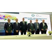
Viridien, SLB Set to Launch ‘Massive’ OBN Survey Offshore Egypt
multi-client model, the dataset will, support Egypt’s position as a regional energy hub. Data acquisition is scheduled to begin in the first quarter of 2026.“The Egyptian Eastern Mediterranean has great potential for development but features some of the most challenging environments for seismic imaging owing to the complex faulting and the Messinian evaporite layer that masks deep reservoirs formed from complex channel sand bodies.“We are pleased to work with our partners, Viridien and SLB, who have decades of specialized imaging expertise in the region and will apply their cutting-edge
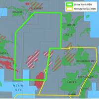
Viridien Kicks Off Seismic Imaging for Utsira North OBN Survey
mature basins.The survey also enriches Viridien’s expanding multi-client OBN portfolio and further consolidates its strategic position in the North Sea as a leading innovative provider of OBN imaging on the Norwegian Continental Shelf (NCS).Viridien’s teams are currently applying their seismic imaging workflows, including the latest proprietary time-lag full-waveform inversion (TLFWI) technology, to deliver unprecedented seismic images of this region.As a result, Utsira North OBN will enhance resolution of the region’s complex geological intervals, illuminating how deep-seated faults
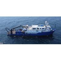
TDI-Brooks Adds to Africa Project List with Nigerian Survey
TDI-Brooks recently secured a contract with Compass Survey Limited to conduct a series of 2D Ultra High-Resolution (2DUHR) seismic site surveys and pipeline route assessments for SPDC offshore Nigeria.These projects involve the acquisition of conventional geophysical data and high-resolution seismic imaging to assess potential hazards, ensuring safe well site clearances and optimal pipeline route planning.TDI-Brooks deployed its survey vessel, R/V Proteus, to Nigerian waters for the project. The primary objective of the project was to identify potential drilling hazards and risks along the proposed


