Metal Shark Debuts Prowler Autonomous Vessel and Frenzy Micro-USV
design allows the vessel to quickly climb to the surface from its submerged state to resume normal operation once the surveillance mission concludes.Prowler is equipped with a computer networked system able to support a multitude of UMAA-compliant command and control, autonomy, targeting, and AI software packages. Prowler’s system architecture provides the forward flexibility to accommodate third party software and/or hardware upgrades to support collaborative intercept capability or other technologies as they may be required.Prowler’s computer system, along with propulsion, mechanical and
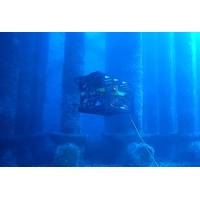
DeepOcean Deploys Its First Autonomous Drone for Inspection of Offshore Structures
, Solstad Offshore and Østensjø Group, is enabling offshore operations to be performed from onshore though digitalised control systems. Deepocean is running the AID from the Remota control center.The AID is based on a Rover MK2 ROV from Argus Remote Systems, with upgraded hardware and software packages. Argus is responsible for AID platform and navigation algorithm. DeepOcean is responsible for the digital twin platform, mission planner software and live view of the AID in operation, while Vaarst is responsible for machine vision camera “Subslam 2x” for autonomous navigation
New Cloud Platform for Subsea Survey Data
insight and information with its cloud based MDP, which enables access to underwater sensor data in near real-time. Further, the platform’s automated analytics improves quality and presents results within standardized parameters, so stakeholders are not required to purchase multiple software packages.“We have taken a completely technology agnostic approach in that data from any subsea sensors can be directly transmitted to our platform, where it is safely stored in a maintained and secured data space, which also provides full management and processing capabilities. From here it is
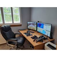
ROV Pilots to Work from Home?
? Ultimately, nothing! The interface will identify a drop and command the ROV into a station keep routine until connection is reestablished or control is taken locally to continue operations or recover the vehicle. There are a number recognized companies offering aftermarket ROV steering or control software packages for multiple systems (not to mention the availability of a completely free and open source solution!), integrating a DVL or other modern sensors into an older vehicle and gaining this ability is no longer a costly trip back to the OEM for modification or even replacement.Can ROV pilots work
Outland Sells ROV With Multiple Tritech Sensors Emas Energy Services
offered by Tritech, allowed us to develop skid packages that are pre-wired and pre-ballasted to quickly attach to the underside of the ROV-2500. Data from the sensors are easily communicated to the surface through Outland Technology’s standard communication network and interpreted by Tritech software packages."Photo courtesy Outland Technolog

Ocean Influencer: Mike Read, Teledyne Marine
global sales and service team, and one common software platform – Teledyne Marine Software (TMS) – across its 23 brands. Read said “TMS is particularly strategic, enabling the Instruments and Imaging products to communicate seamlessly. You can imagine all of the different software packages; it was all over the map, which is understandable. Now we’re working towards all of these products communicating seamlessly, producing better data, and delivering a better user experience.”The integration of Teledyne Marine into three verticals – the large interconnect business
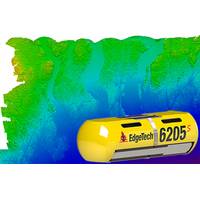
EdgeTech Debuts Next-gen 6205s
available in the 6205s. The 6205s incorporates EdgeTech’s Full Spectrum technology to exceed IHO SP-44, NOAA and USACE specifications for feature detection and bathymetric point data uncertainty. The 6205s also interfaces to most third-party acquisition and processing software packages.

Simulation Meets Automation to Enhance ROV Training and Analysis
in conference rooms around the world for offshore energy stakeholders, which allows us to show how the system functions in real-world scenarios. So demonstrations become very credible and the value proposition of Dex-OS becomes even more apparent.” Forum will be demonstrating the two software packages operating side by side at Oceanology International 2018, 13-15 March at ExCel in London
Meet the Future of Visualization and Mapping Sonars
increase the speed and safety of the process. The new Echoscope4G Surface has been designed with these type of shallow water construction project in mind, offering a cost effective route to delivery these types of projects. The new Surface system can be used with both our proprietary software packages, USE and CMS software, giving the options of deployment on cranes, barges or survey vessels to image and map breakwaters, inshore bridges, piers and complex structures providing real-time assessment the accuracy of the asset placement, any damage to the structure and the effects of any environmental