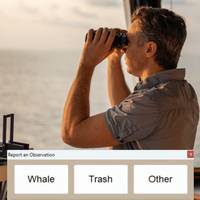
FarSounder: News Citizen Science Capabilities with Whale and Debris Reporting Feature
FarSounder has announced the release of a new citizen science feature in its latest SonaSoft™ software update. Building on its existing Data Sharing Program, this release introduces the ability for users to report whale sightings and floating trash/debris—further integrating marine conservation into day-to-day navigation for Argos users.Since 2019, vessels equipped with FarSounder’s Argos sonars have had the ability to participate in citizen science by contributing to global seabed mapping. Argos users can do this through anonymized sharing of Local History Map (LHM) data, aiding
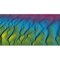
Tech File: AI-powered Bathymetric Data Processing
GeoAcoustics released GS4 software v1.0.25 for GeoSwath bathymetric sonars, adding several upgrades including an Artificial Intelligence dataprocessing system developed in collaboration with the University of East Anglia.The software update is available free for customers already operating GS4 software v1.0.24 and will be demonstrated at OCEANS 2023 in Limerick, Ireland. The new AI processing augments the existing automated filtering in the GS4 software by removing surplus and undesired data autonomously; during acquisition, the system is designed to log clean data, without any user intervention in
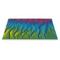
New Software Introduces AI-powered Bathymetric Data Processing
Hydroacoustic technology specialist GeoAcoustics Ltd has officially released GS4 software v1.0.25 for GeoSwath bathymetric sonars, adding several upgrades including an Artificial Intelligence data processing system developed in collaboration with the University of East Anglia. The software update is available free of charge for customers already operating GS4 software v1.0.24.The new AI processing augments the existing automated filtering in the GS4 software by removing surplus and undesired data autonomously; during acquisition, the system is designed to log clean data, without any user intervention
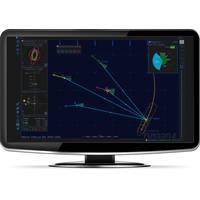
FarSounder, Navtor Partner
e-Navigation tools that are safe, simple and efficient. Similarly, FarSounder’s Argos 3D Forward Looking Sonar is designed to provide safe navigation by detecting many ocean obstacles via an easy-to-understand user interface. According to the pair, this partnership will bring an impactful software update for Argos technology."By implementing the NavtorECDIS Kernel in the FarSounder platform, we bring official electronic navigational chart display (ENC’s) to the FarSounder customers for optimal safety, awareness and flexibility. A significant benefit from this partnership is the integration
Sonardyne Fusion 2 Software Update
Sonardyne International Ltd. has increased the capabilities of its Fusion 2 software package to enable surveyors and construction personnel to do even more, both on and offshore, with their existing hardware.This latest release of Fusion 2 unlocks new benefits, including a simplified surface box-in app and the ability to perform wireless structure deflection monitoring, without having to deploy specialist hardware. Additionally, Fusion 2 now includes 'office’ mode as standard, allowing project teams to plan and fine tune procedures before doing them for real offshore. Multi-user mode now
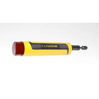
Kongsberg Introduces cNODE Micro
operating using Cymbal’s 500+ channels. Its telemetry capability allows battery status to be read during operation and an integrated tilt sensor can be turned on and off with positioning updates. It also features a pressure relief valve for safety and an external connector for configuration, software update and charging
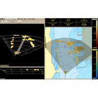
Local History Mapping for FarSounder
associated with the storage and integration of large survey datasets. These investments will accelerate the release of additional bathymetric mapping capabilities. Existing FarSounder customers who wish to add Local History Mapping to systems are encouraged to fill out FarSounder’s Software Update Request form. New customers will automatically receive these capabilities when their FarSounder-500 or FarSounder-1000 sonars are set up and commissioned.
FarSounder Updates Navigation Sonar Software
safety is evident to our customers. Our commitment to vessel safety continues with our latest SonaSoft 3.2 release, making it even easier for vessel operators to understand what is underwater, ahead of their vessels in polar regions, tropical locals and everywhere in between.” The software update is compatible with FarSounder’s existing products and integrates directly with select ECDIS and integrated bridge systems including the Wärtsilä SAM Electronics NACOS Platinum and Transas Navisailor 4000. The upgrade is available to all current and new navigation sonar customers
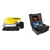
MTR 100: VideoRay
objects and cutting lines, and sonar imagery and positioning systems for navigation, target marking, and target acquisition and reacquisition. VideoRay’s ROV systems and accessories are all “plug and play,” meaning capabilities can be added or removed with either a simple software update or a quick hardware add-on in the field. The MTR100 is Marine Technology Reporter's Annual report on 100 leading companies in the subsea industry, published in the July/August 2015 edition of MTR - http://www.marinetechnologynews.com/Magazine


