
An Oceanographic Music Mix
Music has an important role to play in climate crisis discourse, offering a sonic pathway to bridge the gap between data, understanding, reflection and action, say researchers from Australia’s Monash University.Their Dark Oceanography initiative integrates climate science with experimental music. Following the pathways of eddies from the Eastern Australian Current through the Southern Ocean and across the globe, they used Lagrangian tracking data at an eddy-resolving resolution (0.10ᵒ) and translated it into music.The music was collaboratively developed by a team from The Sound Collectors Lab
Echoexplore 4 aims to Simplify Hydroacoustic Data Management
support: Echoexplore 4 is equipped to read a significantly expanded range of files (compared to earlier releases). Scan, sort and catalog data formats from more than 75 echosounder and sonar models from ASL Environmental, Blueprint Subsea, BlueView, Furuno, Kongsberg Discovery, Navico, Norbit, Nortek, R2Sonic, Reson, Simrad, Sonic, Sound Metrics, WASSP, and more - matching Echoview’s complete range of supported data formats.Expanded licensing: Introducing new software license activation and management options.File indexing: Echoexplore 4 accelerates data access with enhanced file indexing capabilities
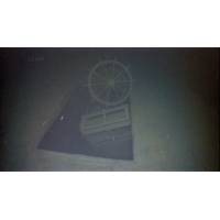
Wreck of WWII-era Cargo Ship Found in the Great Lakes
in Lake Superior. After coming across a particularly deep anomaly, he reached out to the Great Lakes Shipwreck Historical Society (GLSHS) for help in identifying the potential wreck. In 2023 GLSHS Director of Marine Operations, Darryl Ertel, Fountain and crew of the R/V David Boyd, towed a Marine Sonic Technology side-scan sonar over the anomaly and soon realized and it was in-fact a shipwreck. Later ROV dives positively identified the submerged hulk the 244-foot bulk carrier Arlington.On April 30, 1940, the Arlington left Port Arthur, Ontario fully loaded with wheat en route Owen Sound, Ontario
Scientists Working to Provide Detailed Picture of Tonga Volcano Eruption's Aftermath
New Zealand.”Catastrophic consequencesTonga’s Deputy Secretary for Lands and Natural Resources Taaniela Kula says that the eruption of the HT–HH volcano on January 15, 2022, had catastrophic consequences.“It covered our main island of Tongatapu in carpets of toxic ash, generated a sonic boom that traveled around the globe, and caused a tsunami that resulted in deaths and damage as far away as South America.“It also severed both submarine fiber optic cables connecting Tonga with the world, leaving our country in a prolonged “blackout”. The direct economic impact
Seabed Power: Waves Used to Power Up Sabertooth Autonomous Vehicle
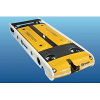
intruder activity.Operating the Sabertooth will demonstrate that subsea residence enables a sustained presence to secure underwater port infrastructure and its ability to support efforts to protect shipping against underwater explosive devices.For the trials, the Sabertooth will be equipped with an R2Sonic Sonic 2024 multibeam echosounder, 2G Robotics ULS-500 PRO Laser Scanner and camera, and the ASL AZFP 70,120 & 200 kHz Acoustic Zooplankton Fish Profiler.The 3000m rated Saab Seaeye Sabertooth is a roaming and hovering system that can operate in both fully autonomous (AUV) and tethered (ROV) modes
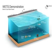
C-Power to Demo Sabertooth AUV with SeaRAY Autonomous Offshore Power System
the Navy’s Wave Energy Testing Site in Hawaii. From shore, operator Hibbard Inshore will remotely program and monitor the Saab Sabertooth AUV during what is reported to be the first ever instance of an in situ renewable energy system supporting a subsea resident vehicle. Equipped with the R2Sonic Sonic 2024 multibeam echosounder, the untethered Sabertooth will patrol the surrounding area to collect sonar imagery of the sea floor and underwater infrastructure. After each mission, that imagery will be communicated back to shore and the Sabertooth recharged via the SeaRAY AOPS.“The
SUBSEA TECH: Compact Hydrographic System for Shallow-Water ‘Gap-Filler’ Surveys
be pre-configured and available anywhere in Europe virtually ‘next-day’, with installation and calibration in less than two hours. Practically plug and play, iHSS-Compact includes everything needed to acquire high quality marine data to new IHO S-44 Exclusive Order standards, including an R2 Sonic 2020 wideband multibeam echosounder, I2NS Inertial Navigation System, versatile mounting solution, survey and post-processing notebook, software and cabling. The iHSS-Compact is also available as a dual head system allowing for more than 200 degrees of swath coverage.“We created the iHSS
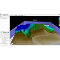
Using High Res 3D Meshes for improved Shape Reconstuction of Marine Survey Data
the data. The QPS suite of tools can support a workflow focused on creating the highest quality 3d data possible. For example, using the new 3D point filter in Qimera 2.2 with the latest mesh technology in Fledermaus 8.2, is a powerful combination. Applying these tools to a data set collected with an R2Sonic Sonic 2024 multibeam operated in UHR (700kHZ) mode, provides a great example of what can be achieved, as shown in Figure 7. In future versions the technology and capabilities for 3D meshes will only improve as more tools are developed to integrate this new data type into various workflows.Figure
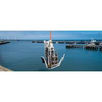
SWORD Seafloor Rig Set for Sea Trials
Royal IHC, a Dutch marine equipment and vessel provider, has said that extensive tests have been completed on a new seabed geotechnical drill designed for offshore wind and oil and gas markets, and the rig will now go on seatrials before hitting the market.The seafloor rig, named SWORD (sonic wireline-operated remote drill), has, according to Royal IHC, has successfully completed an extensive testing program including harbor trials. The seafloor rig has been developed by TI Geosciences LTD, a start-up backed by Royal IHC."SWORD is now ready to be set-up onto its permanent vessel and start sea