NOAA to Deploy Saildrones for Climate Study
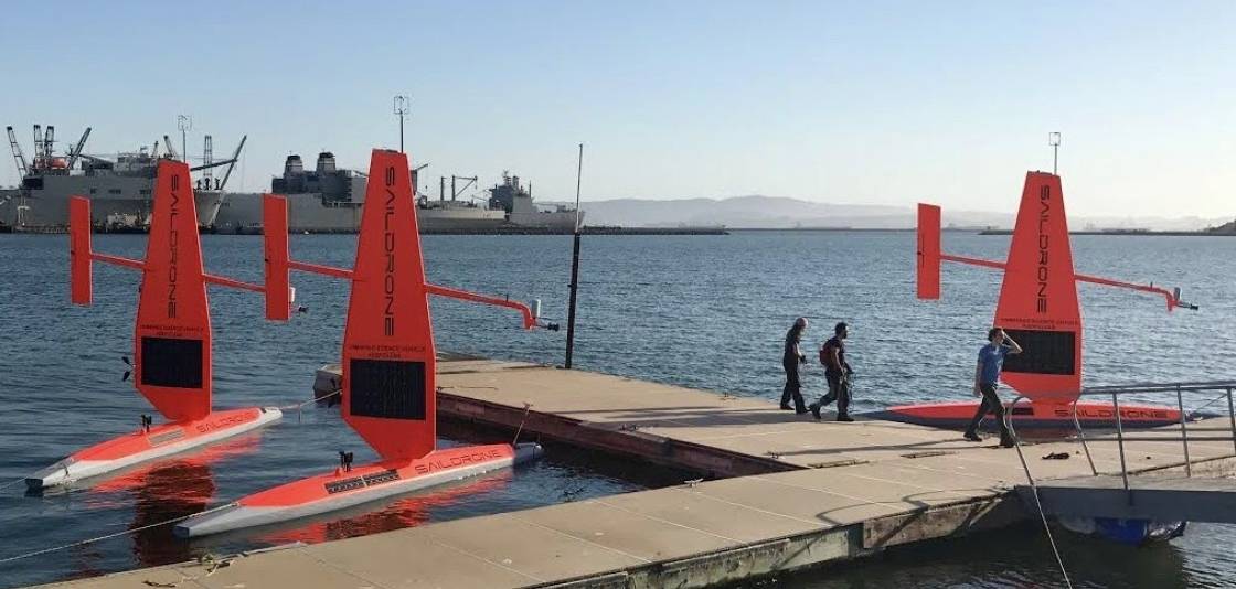
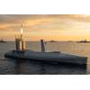
The fleet of Saildrones are being prepared for a summer and fall of science from the Bering Sea to the Arctic to the far reaches of the tropical Pacific Ocean. (Photo: Saildrone Inc.)
During the next four months, NOAA scientists will deploy Saildrone unmanned ocean vehicles to hard-to-reach locales such as the Arctic and the tropical Pacific with the goal of better understanding of how ocean changes affect weather, climate, fisheries and marine mammals.
The Saildrone is wind and solar-powered research vehicle resembling a sailboat, capable of performing tasks at sea such as met ocean data collection, environmental monitoring and fish stock analysis, autonomously or under remote control. For NOAA, the vehicles will soon travel thousands of miles across the ocean, reaching some areas never before surveyed with such specialized technology.
In mid-July, scientists will send off the first unmanned, wind and solar-powered vehicles from Dutch Harbor, Alaska, with two sailing north through the Bering Strait into the Arctic Ocean and another transiting the Bering Sea. Traversing Alaska’s inhospitable waters, the remote-controlled vehicles will track melting ice, measure carbon dioxide in the ocean and count fish, seals and whales.
For the first time, the vehicles will journey through the Bering Strait into the Arctic with a newly adapted system to measure CO2 concentrations.
“We want to understand how changes in the Arctic may affect large-scale climate and weather systems as well as ecosystems that support valuable fish stocks," said Jessica Cross, an oceanographer at NOAA Research’s Pacific Marine Environmental Laboratory, who is using the unmanned system to study how the Arctic Ocean is absorbing carbon dioxide.
A third unmanned Saildrone will survey more than 3,100 nautical miles in the Bering Sea for walleye pollock, Northern fur seals that prey on the fish and North Pacific right whales. This work will build on research conducted during 2016, including a study of fur seal feeding rates.NOAA Fisheries scientists will also attach video cameras to fur seals to record feeding and verify the species and sizes of fish that fur seals are eating.
“We are excited to be able to use the video to see the ocean from a fur seal’s point of view,” said Carey Kuhn, an ecologist with NOAA Fisheries’Alaska Fisheries Science Center. “Critical information about fur seals is still lacking and using the video camera and unmanned sailing vehicle will help us better understand this declining population.”
In September, scientists will launch two more unmanned systems from Alameda, Calif., on a six-month, 8,000-nautical-mile, round-trip mission to the equator to improve the Tropical Pacific Observing System (TPOS). TPOS provides real-time data used by the U.S. and partner nations to forecast weather and climate, including El Nino. The unmanned sailing vehicles will take part in a larger field study with NASA, and visit mooring sites along the array of observing buoys.
“Saildrones can do adaptive sampling like research ships, but at a fraction of the cost,” says Meghan Cronin, PMEL oceanographer. “We’ll be testing whether this new, enhanced tool can provide a suite of measurements at a quality that matches research ships and proven mooring technology. If this is the case, they may become a powerful tool to provide key observations for weather forecasts.”
NOAA’s PMEL began a partnership with Saildrone, Inc. in 2014 through a Cooperative Research and Development Agreement to develop unmanned surface vehicles that collect high quality oceanic and atmospheric observations. NOAA’s PMEL provides engineering expertise on sensors and sampling techniques and Saildrone, Inc. provides unmanned system hardware and software expertise.
“Drones will not replace other oceanic research systems,” Cross said. “Ships, buoys and satellites are still necessary, but these unmanned sailboats offer researchers expansive views of some of the furthest corners of the world's oceans.”