Movella Launches new Xsens Inertial Sensor
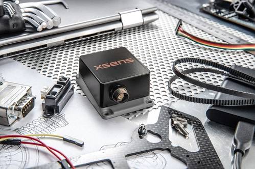
Movella launched its new ‘flagship’ inertial sensor, the high-end industrial grade “Xsens Sirius” Series: the next generation of sensors succeeding the well-known Xsens MTi 100-Series. Image courtesey Movella
Movella launched its new ‘flagship’ inertial sensor, the high-end industrial grade “Xsens Sirius” Series: the next generation of sensors succeeding the Xsens MTi 100-Series.
Featuring Inertial Measurement Unit (IMU), Vertical Reference Unit (VRU) and Attitude and Heading Reference System (AHRS) capabilities, Xsens Sirius is engineered to deliver reliable unmatched 3D, real-time and accurate data in the most demanding conditions. A key feature that sets this series apart is its advanced signal pipeline with analog filtering, ensuring high vibration resistance for precise measurements even in the most extreme-vibration environments. With this new series, Movella aims to further support autonomous vehicle innovators across a range of applications – either land, air or (sub)sea.
This new Sirius series is a game changer for demanding scenarios across diverse vehicle and antenna/payload use cases, including:
- Marine: Deployed on surface vessels and sub-surface robotics, such as remotely operated vehicles (ROVs) and autonomous underwater vehicles (AUVs) for precise navigation or stabilization, providing them with reliable heading- and roll/pitch data or support bathymetry mapping.
- Land based Mobile Robotics: Enabling precise navigation for diverse robotic applications, including indoor mobile robots (AMRs/AGVs) operating in dynamic environments and Outdoor Mobile Robots navigating through rough terrain.
- Precision Agriculture: Delivering accurate 3D orientation data for navigating and controlling autonomous agriculture machinery and smaller mobile robotics.
- 3D Digital Mapping and Surveying: Supporting high-fidelity data capture and georeferencing for aerial, terrestrial, and subsea bathymetry mapping, enabling the creation of accurate and detailed maps and 3D models with e.g. Sonar, LIDAR and camera systems.






 December 2025


