BOEM Extends Public Comment Period on Minerals Lease Sale
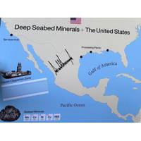
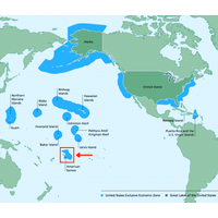
On June 12, 2025, the U.S. Department of the Interior announced its intent to publish a Request for Information and Interest (RFI) for commercial leasing for Outer Continental Shelf (OCS) seabed critical minerals offshore American Samoa. The Department’s Bureau of Ocean Energy Management (BOEM) originally published the RFI in the Federal Register on Monday, June 16, 2025, initiating a 30-day public comment period.BOEM is extending the comment period until 11:59 p.m. ET on August 15 in response to a request from the Governor of American Samoa.“As we extend the comment period, we

US Launches Public Consultation for Potential Seabed Mineral Lease Sale
The US Department of the Interior has announced the publication of a Request for Information and Interest to explore the potential for seabed mineral leasing offshore American Samoa.The Request for Information, scheduled for publication in the Federal Register in the coming days, will launch a 30-day public comment period and mark the first formal step toward what could be the first mineral lease sale in federal waters in over 30 years.The RFI, issued by the Bureau of Ocean Energy Management (BOEM), seeks input from a wide range of voices—American Samoa’s Indigenous community, ocean users

US Launches Process for Offshore Mineral Lease Sale
The US Department of the Interior has announced it is initiating the process to evaluate a potential mineral lease sale in the waters offshore American Samoa.This marks the first such action by Interior in over 30 years and could pave the way for future extraction of critical minerals from the U.S. Outer Continental Shelf.“Critical minerals are fundamental to strengthening our nation's resilience and safeguarding our national interests,” said Secretary of the Interior Doug Burgum. “By providing opportunities to responsibly access deep-sea mineral resources, we are supporting both
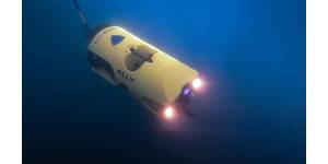
First Deep-Sea Mining Company Asks Trump for International Permit
;s oceans."The industry's financial models are based on wildly optimistic assumptions and fail to reflect the volatility and reality of global mineral markets," said Representative Maxine Dexter, an Oregon Democrat.Privately-held Impossible Metals, which has asked Washington to auction American Samoa's minerals, told the hearing it had no plans to operate without conducting more environmental testing.An engineering expert from the Massachusetts Institute of Technology told the hearing the effects of deep-sea mining may not be as severe as some people have speculated but added the practice
Trump Order Fast Tracks Subsea Mining
territorial waters, roughly up to 200 nautical miles from shore, and companies are already lining up to mine U.S. waters.Impossible Metals earlier this month asked the administration to launch a commercial auction for access to deposits of nickel, cobalt and other critical minerals off the coast of American Samoa.Shares of The Metals Company - among the most prominent of deep-sea mining companies - rose on Thursday by roughly 40% to hit a 52-week high of $3.39 per share after the Reuters report earlier in the day on the executive order."With a stable, transparent, and enforceable regulatory pathway
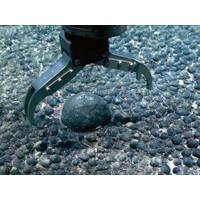
Impossible Metals Seeks Mining Lease Near American Samoa
Deep-sea mining firm Impossible Metals said on Tuesday that it has asked U.S. federal officials to launch a commercial auction for access to deposits of nickel, cobalt and other critical minerals off the coast of American Samoa.The waters around the Pacific Ocean territory are estimated to contain large amounts of potato-shaped rocks known as polymetallic nodules filled with the building blocks for electric vehicles and electronics.The request from privately held Impossible Metals asks the U.S. Department of the Interior's Bureau of Ocean Energy Management - which oversees mineral deposits in
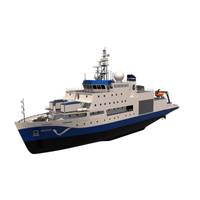
NOAA Reveals Names of its New Mapping Vessels
and Bering Sea, playing a key role in ocean surveying. Surveyor Bay in Alaska was named in recognition of its contributions during surveys conducted in 1936. The second Surveyor served from 1960 to 1995, conducting hydrographic surveys across diverse locations, from Alaska’s Norton Sound to American Samoa.Both the Surveyor and Navigator will be built by Thoma-Sea Marine Constructors in Houma, La., with completion expected in 2027 and 2028. The contract includes options for up to two more vesselsThe vessels are primarily designed for ocean mapping and nautical charting, furthering NOAA’s
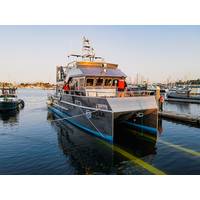
AAM Launches 50’ Research Vessel for NOAA
, and we are always excited to work with this essential agency. The Office of Marine Sanctuaries serves as the trustee for a network of marine protected areas encompassing more than 600,000 square miles of marine and Great Lakes waters from Washington state to the Florida Keys, and from Lake Huron to American Samoa.”(Photo: All American Marine)On board the vessel there is approximately 250 square feet of working space on the aft deck, with a complete complement of working gear and an extensive grid of deck sockets. The deck sockets are spaced every two feet and allow equipment and gear to be secured
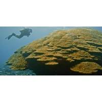
Record-sized Coral Colony Discovered in American Samoa
A new record size coral colony at Ta’u Island in American Samoa identified by NOAA-funded researchers is said to be even larger than the island’s Big Momma colony, one of the largest in the world.The colony was measured and described during a monitoring survey conducted by a multi-agency team including NOAA’s National Marine Sanctuary of American Samoa (NMSAS), American Samoa’s Coral Reef Advisory Group, American Samoa’s Department of Marine and Wildlife Resources, and the National Park of American Samoa, and funded by NOAA’s Coral Reef Conservation Program. The