Blue Institute Reveals New BX6 Blue Excelerator Cohort
, autonomous operations, and hardware/software integration.DUV of Denmark, which is developing sensing and engineering technologies for demanding marine environments.Innovite Solutions of Texas, which is focused on climate-sensitive maritime logistics and cold-chain compliance.Diversican of Wilmington, Delaware, which is advancing ballast water treatment and related separation technologiesWater SecurityFocus: Resource management, treatment, and terrestrial-maritime overlap.C1iN of San Diego and Washington, D.C., which is developing a methane-powered microbial platform for agriculture and climate mitigation
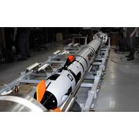
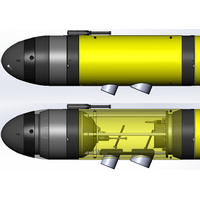
REMUS 620 UUV Validated for Torpedo Tube Deployment
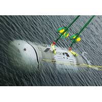
docking technology, successfully completed a full end-to-end dry checkout of the Autonomous Underwater Vehicle/Shock and Fire Enclosure Capsule (AUV/SAFECAP) "All-Up Round" (AUR) in the Virginia-class Cradle Payload Integration Facility (VCCPIF) and its Mk71 torpedo tube. This follows USS Delaware (SSN 791), built by HII, successfully completing the first-ever forward-deployed launch and recovery of a UUV via submarine torpedo tube with the Yellow Moray equipped REMUS 600 UUV.HII is expanding the U.S. Navy’s undersea dominance and range with state-of-the-art REMUS technology and delivery
PODCAST - Underwater Robotics: Giving Marine Scientists Superpowers
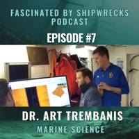
PODCAST: Fascinated by Shipwrecks - Episode 7 – Guest: Dr. Art Trembanis, University of Delaware According to marine scientist and University of Delaware professor Art Trembanis, we’ve only mapped about 25 percent of the sea floor. However, advances in underwater robotics continue to expand the depth and range of ocean exploration. In this episode, host Kathy A. Smith talks with Trembanis about his career as a coastal geologist and how that intersects with working on shipwrecks, his experiences mapping the Bikini Atoll nuclear test site, finding the SS Choctaw, and where he
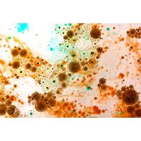
Bacteria Fuel Cell Could Power Ocean Sensors
and includes collaborators from eight other institutions and firms: Battelle, the George Washington University, Harvard University, the Institute of Marine and Environmental Technology at the University of Maryland, Baltimore County, James Madison University, Johns Hopkins University, the University of Delaware and Yokogawa Corp. of America.In addition to the $7.8 million granted for Phase 1 development and deployment, an additional $3.4 million award is possible to support Phase 2, which will include deployment in multiple settings and generate 100 watts of power
UUV Integration Will Transform Submarine Tactics
to hide, emerging underwater capabilities are poised to reorder the undersea battlespace, and will force the development of new tactics to successfully employ and counter them.Recently, the U.S. Navy announced a critical step toward operationalizing one of these capabilities. By the end of 2024, the USS Delaware, a Block III Virginia-class attack submarine (SSN), will put to sea with an integrated torpedo tube launch and recovery (TTLR) UUV system. The announcement comes just eight months after the Delaware successfully deployed and recovered a medium UUV using the "Yellow Moray" system,
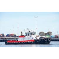
US Harbor Craft: Measuring Opportunity for Zero Emissions
; Lewis added. “That said, some of the excursion vessels that venture further offshore may be less suited for short- and medium-term transition to hydrogen or fully electric technology.”The vast majority (73%) of the U.S. harbor craft fleet is located within 10 states: Alaska, California, Delaware, Florida, Louisiana, Massachusetts, Missouri, New York, Texas and Washington. (Source: intelatus Global Partners
Teledyne Integrating the Kongsberg EK80 WBT Mini Into Its Slocum Gliders
, Gretel, has been deployed several times with the EK80 gathering valuable data for fisheries research. This collaborative effort provides a formal and streamlined integration. Sales of this new echo sounder package have already commenced with scientists at Akvaplan-niva of Norway and the University of Delaware ordering the first units for delivery summer of 2024.Dr. Tyler Hennon performing final checkout on the University of Alaska’s EK80-enabled Slocum glider Gretel before launch in Resurrection Bay, Alaska. (Photo: Hank Statscewich)"The integration of the scientific echo sounder EK80 from
Not All Underwater Reefs are Made of Coral
from their placed location, damaging nearby habitat, or deteriorate quickly in salt water.Reefed objects can be sunk only in predesignated areas of the U.S. seafloor. These zones, which are usually sandy sea bottom, total about 2,200 square miles (5,800 square kilometers) – roughly the area of Delaware.Each zone can support the creation of many individual reefs over multiple decades. Within a given zone, reefed objects are usually placed away from one another, separated by large swaths of sand. This maximizes the amount of sand habitat, where some reef fish forage.The extent of artificial reefs
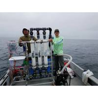
Stepping on the Gas: Rochester Researchers Team to tackle Methane Emissions
reliable in continuously collecting data with less researcher oversight.Dr. DongJoo Joung and Dr. Mihai Leonte (University of Rochester) deploying equipment for methane sampling. All images: University of Rochester/John KesslerA hull of a research cruiseThe cruise spent 26 days on the water, leaving Delaware to travel down the east coast of the United States, around Florida, into the Gulf of Mexico and back. The boat “ping ponged” along the coast, getting as close to the shore as possible and then sailing out across the shelf, all while continuously collecting data from a series of instruments


