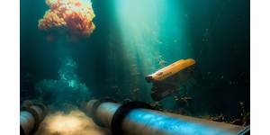
New ASV Delivered for Post-hurricane Surveying
bathymetric surveys, water quality analysis, hydrographic surveys, shallow water, force multiplier and many other applications. The ASV was delivered with a fully integrated Edgetech 6205 multi-beam echo sounder (MBES), R2Sonic 2022 with Type II I2NS motion reference unit and dual antenna GPS system, as well as a surface sound velocity probe and a cast winch deploying a CTD—all tightly integrated with HYPACK software
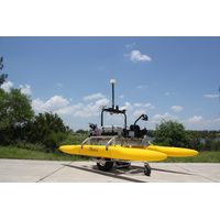
Canadian Hydrographic Service Grows Its USV Fleet
, cost-reducing activities is being developed for both traditional survey tasks and survey tasks in previously denied, and currently unsurveyed, areas.The new USVs were delivered with a fully integrated R2Sonic multi-beam echo sounder (MBES), associated motion reference unit and dual antenna RTK GPS system, as well as a surface sound velocity probe and a cast winch deploying a CTD—all tightly integrated with HYPACK software.“The USVs will be used extensively to improve bathymetric, hydrographic and nautical data throughout Canada for waterways, estuaries and coastal bathymetric surveys
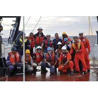
Researchers Set out to Study the Southern Ocean
, Alicia Mountford and Liam Rogerson from Newcastle University have joined the ORCHESTRA research project (Ocean Regulation of Climate by Heat and Carbon Sequestration and Transports) to carry out sea surface measurements using a Wave Glider. Fitted with a GBS antennae – a highly accurate GPS system – the glider will survey the ocean surface, measuring properties such as near-surface meteorology (wind, air pressure and air temperature), waves, ocean temperature and currents. Led by the British Antarctic Survey (BAS), the aim is to gain a better understanding of the mechanisms
Water Linked Launches Underwater GPS System
Norwegian technology supplier Water Linked has launched a new Underwater GPS system that leverages traditional GPS along with Water Linked’s unique underwater acoustic positioning technology. Designed to enable underwater positioning in a wide new range of marine technology applications, this system is priced at $4,800, half the cost of existing underwater positioning systems. The Underwater GPS Developer Kit is available for order with the first deliveries expected in June 2017. California-based Blue Robotics is the first partner to integrate the Water Linked Underwater GPS
MTR 100: RECAB
harsh environmental conditions including, dust, humidity, extended temperature, shock, vibration, and EMC-requirements. RECAB MPU (Maritime Processing Unit) The RECAB MPU (Maritime Processing Unit) is designed to be versatile; easy to change or add hardware functionality such as AIS or other GPS system modules. This flexibility enables deployment in several other application areas. • Compact and scalable fanless high performance Maritime Processing Unit using Intel Ivy Bridge Core i3. • Flexible design enables a range of optional modules and functionalit

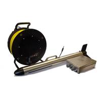
PulSAR: New SSS for SAR Operations
and structures in great detail. PulSAR operates in a frequency range of 600 kHz to 1 MHz and both FM and CW source signals can be selected in order to optimize the range and resolution for the given survey task. PulSAR is battery or mains powered, using 24 VDC or 110/230 VAC. It has an integrated GPS system that provides positioning information with SBAS differential corrections and an external positioning system can be connected via a serial port. The system is delivered with a dedicated software package to be run on a laptop computer connected via Ethernet to the deck unit. It allows the user to
New Side Scan Sonar for SAR Operations
achievable with the system results in seafloor maps with detail that may form the basis for scientific investigation in areas such as marine geology and geophysics as well as marine archaeology.” PulSAR is battery or mains powered, using 24 VDC or 110/230 VAC. It has an integrated GPS system that provides positioning information with SBAS differential corrections and an external positioning system can be connected via a serial port. The system is delivered with a dedicated software package to be run on a laptop computer connected via Ethernet to the deck unit. It allows the
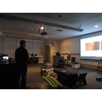
HYPACK Used at Texas A&M Nautical Archaeology Program
able to gain experience in HYPACK for their study. After learning vessel safety and boat operations the undergraduates were able to focus on learning HYPACK. Each student was able to successfully learn how to configure HYPACK with a single frequency side-scan sonar, a magnetometer, and a Trimble GPS system. They were also able to easily learn how to plan and run the survey. After the equipment was connected and everything was running properly, the students began collecting data on an unidentified wreck off of Pelican Island. They collected this data with both the side-scan sonar, and Magnetometer
Development & Deployment of Brazil’s First Buoy System
configured system ID numbers (01 -10). The buoy controller and all systems integration were completed by AMBIDADOS in Rio. The data logger is a Campbell Scientific CR1000 with daily data telemetry undertaken by an onboard INMARSAT transmitter, a Skywave IsatData Pro with and integrated GPS system for buoy positioning and watch circle monitoring. A second, positioning device (GlobalStar Tracker) is also installed on the tower shelf for back-up buoy position monitoring should the Skywave system go down. The complete system is powered by an onboard battery pack that supplies the