Deeply Innovative: Drivers in Subsea Defense
vehicles operating deep underwater or in contested environments.Ekinox inertial navigation system. Credit: SBG SystemsEllipse MEMS-based inertial system. Credit: SBG SystemsNortek’s compact Doppler Velocity Logs (DVLs) and the Nucleus 1000 navigation system are enabling small AUVs and diver guidance systems to operate autonomously with remarkable accuracy. Paired with SBG Systems’ MEMS-based inertial sensors, these solutions are shrinking the size and cost of precision navigation.Nucleus 1000 navigation system. Credit: NortekNortek’s Doppler Velocity Log (DVL). Credit: NortekSensing
OPT Secures US Patent for Floating Marine Vehicle Charging System
to address the increasing demand for clean maritime operations, the invention enables electric vessels, including uncrewed surface vehicles (USVs), to locate, dock with, and recharge from a floating energy platform while at sea.The patent covers multiple key features, including signal-emitting guidance systems for dynamic maritime docking, flexible and secure mooring structures to stabilize vessels during energy transfer, wired and wireless energy delivery mechanisms, and options for wave-powered self-sustaining energy generation.The innovation is core to OPT’s vision of scalable, intelligent
Overwatch: Advancing NATO’s Maritime Situational Awareness via Commercially Available Space-based Assets
in the battle for an ISR advantage. In reality, the issue of quantity versus quality when it comes to next-generation ISR is yet to be resolved. This is particularly the case in contested environments where targets are mobile or hidden, defenses have proliferated, a drone’s guidance systems can be jammed and networks compromised. In such a world, more sophisticated platforms deploying multiple sensors of greater range and acuity and carrying defensive and even offensive capabilities may make more sense.It is widely agreed that as civilization entered the “Age of Information
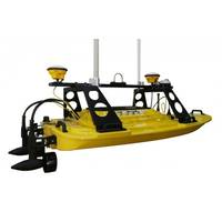
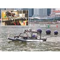
Trimble Outfits New Teledyne Unmanned Survey Vessel
designed and manufactured by Teledyne Oceanscience, is a high-resolution shallow water hydrographic unmanned survey vehicle with the newly released Odom Hydrographic Echotrac E20 Singlebeam Echosounder and dual antenna Trimble BX992 GNSS heading receiver. “Trimble's experience in GNSS guidance systems, and Teledyne's leadership in shallow-water hydrographic surveying provides an ideal solution for marine construction contractors and surveyors,” said Kevin Garcia, General Manager of Trimble Civil Specialty Solutions. “The Teledyne Z-Boat 1800T release means that near-shore
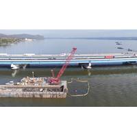
Tappan Zee Constructors ‘See’ Below the Hudson
see it, so you really don’t know what’s happening,” said Lou Nash, president of Measutronics Corporation, an integrator of Trimble Marine technology.Tappan Zee Constructors consulted with Nash, the Measutronics team and Trimble to overcome these challenges. The positioning and guidance systems used included Trimble and Teledyne components – Trimble software, hardware, and sensors for positioning, guidance and tracking of machines, and Teledyne marine imaging sonar for subsurface applications. Measutronics calibrated the equipment and installed the systems and all the sensors
The Autonomous Future of Seabed Mapping
in Seabed Mapping 4D Ocean believes that autonomous solutions are far more efficient than traditional methods of mapping. Autonomous surface vehicles (ASVs), unmanned aerial vehicles (UAVs) and autonomous underwater vehicles (AUVs) can be deployed from almost anywhere, with state-of-the-art guidance systems which make for better survey progress, and fewer infill lines. ASVs are not constrained by harbors, so transit times are much reduced, and all systems are battery powered, using clean and green energy. Autonomous systems do not require ports and can also access areas which are
Warner Linear Steers Unmanned Vessel Design
of obstacles, as well as an underwater search for an acoustic source, was designed to test the design and implementation of the sensors and control systems. One of the more basic elements of the design are the propulsion and steering systems that have to be integrated with the vision and guidance systems so that the vessel can avoid obstacles. The team from Newcastle chose to design a linkage that turned the electric outboard motors using linear actuators. Following some initial research, the designers contacted Warner Linear to discuss the challenge and find a solution. Based on the
BG Group & the FlatFish AUV
crash in every 200 hours of operations, our system has a 99% chance to recover from this crash. It would still mean an emergency vessel recovery every three years in average for a daily operated FlatFish,” said Zagatti. Artificial intelligence is extensively used in the FlatFish’s guidance systems, mission planning and in selecting inspection sensors, according to Zagatti; “Besides being cost-efficient – it can reduce inspection of subsea infrastructure from 30% to 50% – subsea inspection campaigns are subjected to limitations such as sea condition and market availability
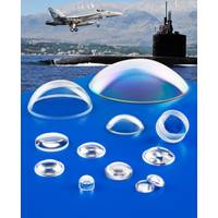
Sappire Optical Domes Resist Corrosion, Fast-moving Particles
Custom fabricated sapphire domes that feature a superior combination of optical and mechanical properties for protecting guidance systems, sensors and other devices in harsh airborne and subsea environments are available from Meller Optics, Inc. of Providence, Rhode Island. Meller Sapphire Optical Domes feature Moh 9 hardness which is second only to diamond in terms of hardness and provide up to 85% transmission uncoated in the UV and IR, and up to 99% when antireflective coated on two sides. Ideally suited for protecting guidance systems in military and commercial applications, they can