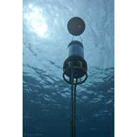
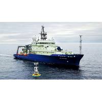
Ocean-Bottom Seismometers Play Crucial Role in Offshore Sensing
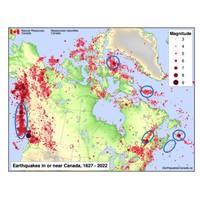
offshore seismic activity and assess earthquake and tsunami hazards in this high-risk area.Endeavour was a time-sensitive collaboration aimed at “catching” a volcanic eruption, which scientists expect to erupt within the next year or so. This is focused on the Endeavour Ridge, part of the Juan de Fuca Ridge system, which lies off the west coast of Vancouver Island.For these projects, NFSI was able to use a large Canadian Coast Guard ship equipped with a dedicated over-the-side pole deployment for the Gyro USBL transceiver.Operations during Pacific Coast Seismic Assessment for Faults and Earthquakes
Monitoring the Restless Earth for the Next “Big One”
in Canada to northern California.Between 2021 and 2025, USGS has installed four monitoring sites on the seabed off the US Pacific coast at the southernmost extent of this zone.They are part of a wider network along the Cascadia Subduction Zone where subduction involves three plates, the Explorer, Juan de Fuca and the Gorda, sliding beneath the North American Plate, creating the potential for magnitude 9+ earthquakes and large tsunamis.The USGS GNSS-A sites, each with three Fetch transponders, are on the southernmost Gorda plate where the uncertainty of the Gorda plate motion relative to the North American
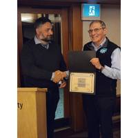
ASL’s Fissel Named a Fellow of CMOS
and an M.Sc. in Physical Oceanography in 1975. His graduate research, carried out under Professor Steve Pond, was followed, in 1975, by working as a Physical Oceanographer at the Government of Canada’s Institute of Ocean Sciences. His initial studies focused on currents in the Strait of Juan de Fuca and circulation patterns in the eastern half of the Northwest Passage.In 1977, he joined Arctic Sciences Ltd. as a founding partner and Director of Oceanography, leading a 1977 physical oceanographic study of Lancaster Sound. Over the next 45 years, David played a major role in the evolution of
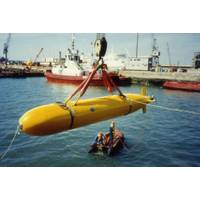
Subsea Vehicles: Diving into the Autosub Program
;s Odyssey II had completed a survey off British Colombia and International Submarine Engineering’s Theseus laid a 175km fiber optic cable under sea-ice in the Canadian Arctic. Woods Hole Oceanographic Institution’s Autonomous Benthic Explorer had also been making observations around the Juan de Fuca ridge. This wasn’t inexpensive work. Up to that point, NOC had spent some £5.3 million on Autosub-1 development (in 1989 terms).Following demonstration missions off Dunstaffnage Marine Laboratory (now the Scottish Association of Marine Science), Autosub-1 started doing the science
Teledyne Benthos Acoustic Modems Aid in Innovasea Fish Tracking
to support the Ocean Tracking Network (OTN)—an aquatic research platform that connects universities, businesses, not-for-profit organizations, and governments to track animal movements on a global scale. The OTN’s Pacific Ocean acoustic receiver arrays in the Queen Charlotte Strait, Juan de Fuca Strait, and the Northern Strait of Georgia span from Vancouver Island to the mainland, provide an integrated series of regional gates to document the coastal movements of acoustically tagged juvenile salmon migrating to sea, adult salmon returning from the sea to rivers in the region to spawn
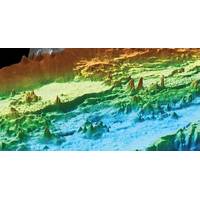
MBARI: Hydrothermal Mapping is Heating up
A recent paper by Monterey Bay Aquarium Research Institute (MBARI) has revealed almost 600 hydrothermal chimneys around the Endeavour Segment of the Juan de Fuca Ridge, about 350 kilometres (220 miles) northwest of Washington State. The vents, located in a valley about 14 kilometres (8.6 miles) long and 1.5 kilometres (0.9 miles) wide, has been studied previously, but never mapped until now because of difficult access.Hydrothermal vents are created by magma beneath the seafloor that heats water within the surrounding bedrock, emerging from the seafloor in the form of underwater seeps and geysers.
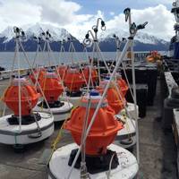
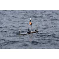
Canada's New Observatory Uses 'Seafloor GPS'
hazards is to be deployed offshore Vancouver, Canada, using long endurance acoustic sensing technology supplied by Sonardyne International Ltd.The new Northern Cascadia Subduction Zone Observatory (NCSZO) will use a “seafloor GPS” network to monitor long-term movements of the subducting Juan de Fuca plate and overriding North American tectonic plate. Data gathered by the new observatory will play a critical role in informing assessments of earthquake and tsunami risk to the large populations of the Pacific North-West.The NCSZO is led by Ocean Networks Canada (ONC)—an initiative of the
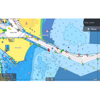
C-MAP Launches High-res Coastal Bathymetry
and CaribbeanPassamaquoddy Bay to Block IslandCape Cod, Long Island and Hudson RiverBlock Island to NorfolkNorfolk to JacksonvilleFlorida and the BahamasSt. Lucie Inlet to New OrleansNew Orleans to BrownsvilleSan Diego to Santa CruzPoint Sur to Cape BlancoCape Blanco to Cape FlatteryPuget Sound, Juan de Fuca and San Juan IslandsVictoria, British Columbia to Cape ScottSan Juan Islands to Nigei IslandsQueen Charlotte Sound to Dixon EntranceHawaiian Island
NSF Awards Contract to Continue Ocean Observatories Initiative
of OOI assets for which it is currently responsible: WHOI will operate the Pioneer Array off the Northeast U.S. coast and the Global Arrays in the Irminger Sea off the southern tip of Greenland and at Station Papa in the Gulf of Alaska; UW will operate the Regional Cabled Array that extends across the Juan de Fuca tectonic plate and overlying ocean; OSU will operate the Endurance Array off the coast of Washington and Oregon; and Rutgers will operate the cyberinfrastructure system that ingests and delivers data for the initiative. In addition, WHOI will serve as the home of a new OOI Project Management Office


