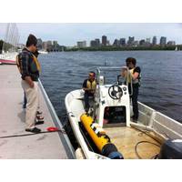
Good Undersea Vehicles Come in Small Packages
the system architecture. This supports a tool intended for end user modifications and upgrades. The vehicle leverages common drone technologies and employs the open-source ArduSub control firmware, this offers both useful features and an extensive user community. The operator controls the ROV with a laptop computer and game controller. The open-source QGroundControl application provides the user interface. This potent combination of technology is offered at a remarkably low entry price of $3,500. This brings a truly capable ROV to a significant new audience.A BlueROV (Credit Blue Robotics, Jeff Milisen)Also
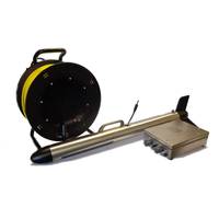
JW Fishers Debuts New Marine Magnetometer
or automatic tuning. The base system includes a 200-foot depth rated towfish, 150 feet of Kevlar reinforced tow cable, and a topside control box. Optional USB data output and Tracker 3 mapping software are available which allow the magnetometer readings to be displayed and stored on a laptop computer. Target position is displayed and recorded on the computer along with GPS coordinates. An optional Microsoft Surface tablet can be mounted in the control box lid which streamlines the system and eliminates the need for a separate laptop computer
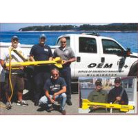
Dive Teams Depend on Detection Devices
commander made the decision to deploy a SCAN-650 scanning sonar recently acquired from JW Fishers. The sonar transmits a sound wave that sweeps a circle up to 200 feet in diameter. The wave bounces off any object on the bottom and the return signal is sent topside where it produces an image on a laptop computer showing the operator exactly what’s down there, regardless of water clarity. Officer Paul Romano reported, “We set up the SCAN-650 and found a target relatively quickly. A diver was splashed and confirmed it was the victim. The sonar was instrumental in helping make a fast recovery

PulSAR: New SSS for SAR Operations
or mains powered, using 24 VDC or 110/230 VAC. It has an integrated GPS system that provides positioning information with SBAS differential corrections and an external positioning system can be connected via a serial port. The system is delivered with a dedicated software package to be run on a laptop computer connected via Ethernet to the deck unit. It allows the user to plan and conduct the survey and acquire sonar data with embedded positioning information. www.km.kongsberg.com (As published in the March 2015 edition of Marine Technology Reporter - http://www.marinetechnologynews.com/Magazine
New Side Scan Sonar for SAR Operations
powered, using 24 VDC or 110/230 VAC. It has an integrated GPS system that provides positioning information with SBAS differential corrections and an external positioning system can be connected via a serial port. The system is delivered with a dedicated software package to be run on a laptop computer connected via Ethernet to the deck unit. It allows the user to plan and conduct the survey and acquire sonar data with embedded positioning information. The data can be processed, visualized and interpreted in the software package and exported in industry standard formats to third party packages
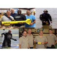
Military, Government Agencies Utilize Side Scan Sonars
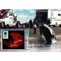
clarity. In addition, the sonar is able to search large areas quickly, scanning several hundred feet of ocean, lake, or river bottom with each pass of the boat. The acoustic beam reflects off any objects lying there and the data is sent topside where vivid color images are displayed and stored on a laptop computer. Side scan can easily locate a variety of targets including sunken boats, submerged vehicles and drowning victims. The sonar saves hours of search time while also increasing the safety factor. Towing a side scan over an area produces a detailed map of the underwater terrain so divers know
Scanning Sonar for Search and Survey
sonar. The SCAN-650 allows the operator to “see” much further than the video camera because the sonar’s sound wave sweeps a 200 foot diameter circle around the ROV. The wave bounces off any object on the bottom and is sent topside where it produces an image of the object on a laptop computer. Using their ROV equipped with scanning sonar the Washington team was finally able to locate the fourth victim 125 feet from where the vehicle entered the water and on the opposite side of the bridge. Another department successfully using scanning sonar is the Stanislaus County Sheriffs
Bluefin, MIT Demonstrate AUV Plug-n-Play Payload Autonomy
field deployment of the payload autonomy operational paradigm we have been developing over the last decade," said Professor Henrik Schmidt, Director of the LAMSS at MIT. "It allows us to test the mission configuration by connecting the payload computer carrying the autonomy software to a laptop computer with a simulation environment representing realistic platform dynamics and sensory input. The autonomy software is then installed on a small platform such as the Bluefin-9 for field-testing of the autonomy at low cost before it is finally installed on the operational platform such as the Bluefin-21