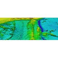
Raymarine Collaborates with Seabed 2030 Project to Advance Seabed Mapping
regions.The Nippon Foundation, a private philanthropic organization based in Tokyo, has been the principal funder of GEBCO’s capacity-building and mapping initiatives for over two decades. Through its support of Seabed 2030 and the GEBCO-Nippon Foundation Training Program at the University of New Hampshire, it has helped train over 100 ocean mappers from more than 45 countries.To date, only 27.3% of the world’s seafloor has been mapped to modern standards. Seabed 2030 aims to close this gap by 2030 through international collaboration, open data sharing, and innovative partnerships like this one
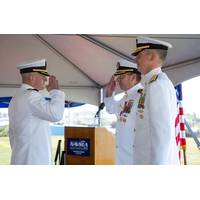
NUWC Division Newport Hosts Change of Command
change of command ceremony held on Sept. 3. Behm, a 2004 graduate of the U.S. Naval Academy, most recently served as the commanding officer of the USS Hartford (SSN 768). His previous submarine tours include the USS Oklahoma City (SSN 723), USS Georgia (SSGN 720), USS Florida (SSGN 728) and USS New Hampshire (SSN 778). Ashore, he served as shift engineer at the Nuclear Power Training Unit, junior board member on the Pacific Fleet Nuclear Propulsion Examination Board, and chief of operations for the Office of Stockpile Sustainment at the National Nuclear Security Administration. “It&rsquo
SubCom Deploys One Million Kilometers of Subsea Cable Systems Globally
SubCom recognized a historic organizational milestone: the deployment of more than one million kilometers of subsea cable. At a ceremony held at SubCom’s campus in Newington, CEO David Coughlan accepted a special commendation from the State of New Hampshire by Governor Kelly A. Ayotte in celebration of the company’s industry-first achievement.SubCom, whose origins date back to the mid-1800s, has been a global leader in subsea cable design, manufacturing, and deployment since its entry into the communications industry in 1955. INearly all of the world’s data is transmitted via secure
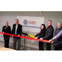
Klein Marine Systems Dedicates Sonar Lab at UNH
Klein Marine Systems, a global leader in sonar technology, announced the dedication of the Klein Sonar Innovation Lab at the John Olson Advanced Manufacturing Center, University of New Hampshire (UNH).Additionally, Klein has renewed its Industry Partnership agreement with UNH’s Center for Coastal and Ocean Mapping/Joint Hydrographic Center (CCOM/JHC). As part of this initiative, Klein Marine Systems has loaned a sonar system to CCOM, providing students with hands-on access to industry-leading technology.

Storm Chaser Cyrena Arnold to Sign Books at R.M. Young AMS 2025 Booth
accomplishments begin back in 2006 when she received a NASA certificate of appreciation for her efforts towards aviation safety while employed at a NASA contractor, AirDat. She then installed weather stations on the remote Alaska tundra for six years with McVehil-Monnett Associates, then came to New Hampshire as the Director of Summit Operations for the non-profit Mount Washington Observatory and was an NH1 News TV Meteorologist. She has made guest appearances on WIRED, Good Morning America, Insider, USA Today, GQ, Popular Science, The Morning Show, and more. And she was named Mrs. New Hampshire in
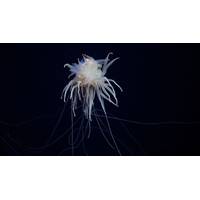
“Flying Spaghetti Monsters” Photographed at Newly Discovered Seamount
a high seas marine protected area.The seamount discovery is one of many from a 28-day expedition to the international waters of the Nazca Ridge led by Schmidt Ocean Institute in partnership with Ocean Census and the Center for Coastal and Ocean Mapping/Joint Hydrographic Center at the University of New Hampshire.The newly discovered underwater mountain is over 1.9 miles (3109 meters) tall and supports a thriving deep-sea ecosystem. In addition to mapping the seamount, the team conducted an exploratory dive with an underwater robot on one of the mountain’s ridges, finding sponge gardens and ancient
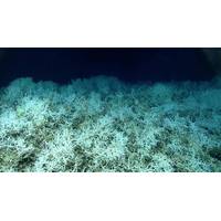
World's Largest Known Deep-sea Coral Reef Habitat Found
included imagery from 23 submersible dives in addition to mapping data, were collected as part of a coordinated, multi-year ocean exploration campaign involving NOAA Ocean Exploration, NOAA Ocean Exploration Cooperative Institute partners Ocean Exploration Trust and the University of New Hampshire , the Bureau of Ocean Energy Management, Temple University , and the U.S. Geological Survey, with contributions from Fugro , the NOAA Deep Sea Coral Research and Technology Program, and the South Atlantic Fishery Management Council .The largest area, nicknamed "Million Mounds" by scientists
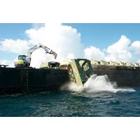
Not All Underwater Reefs are Made of Coral
a push toward developing structures specifically for use as artificial reefs.Planes, trains and automobilesFor our study, we gathered records of intentional reefings dating back to 1899 and occurring off artificial all U.S. coastal states, except for six without artificial ocean reef programs: Maine, New Hampshire, Connecticut, Oregon, Washington and Alaska.For some of these events, especially in recent decades, there were detailed records of the sizes and quantities of sunken objects or seafloor maps from which we could derive these measurements. These reefs were easy to quantify.Other records, including

The Curious Case of the 1,200 MW Transmission Size “Limit” in New England
up to 2,000 MW, the Boston-based Mystic Generating Station units 8 and 9, which collectively are a 1,600 MW single source loss due to a common natural gas fuel source issue from an adjacent liquefied natural gas gasification facility, and the region’s two remaining nuclear plants, Seabrook in New Hampshire and Millstone in Connecticut, can all operate above 1,200 MW and up to their limits as long as system generation dispatch and resulting power flows on the New York and PJM systems allow. The 2016 planning process limit only applies prospectively to new resources – HVDC lines interconnectin
 December 2025


