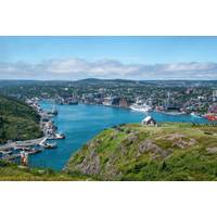
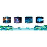
Student Teams From 16 Countries Descend on Newfoundland for the 2026 MATE World Championship
The 2026 MATE ROV Competition World Championship will welcome top student teams from around the world to St. John’s, Newfoundland & Labrador, Canada. Now in its 24th year, this internationally recognized competition brings together students to showcase their skills in engineering, technology, teamwork, and problem-solving. Hosted by the Fisheries and Marine Institute of Memorial University and the National Research Council Canada, the event marks the culmination of a global competition season, convening the top 86 teams from 16 countries from around the globe, including North America
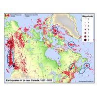
Ocean-Bottom Seismometers Play Crucial Role in Offshore Sensing
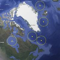
, where tectonic plates pushing together suggest a large earthquake is due.Canada is all too familiar with the impact of offshore earthquakes. The magnitude 7.2 Grand Banks earthquake of 1929 triggered one of the most destructive tsunamis ever recorded in the country, devastating coastal communities in Newfoundland and Cape Breton. As a result, Canada’s National Facility for Seismological Investigations (NFSI) was set up in 2021 to investigate, characterize and predict this risk, in Canada and overseas.Based at Dalhousie University and supported by a partnership of 10 Canadian universities, NFSI was
Fugro Relocates to COVE Innovation Hub; Strengthens Atlantic Canada Presence
(eROVs). Fugro also delivers full water‑column and coastal mapping using its Rapid Airborne Multibeam Mapping System (RAMMS), which can be deployed from small, crewed aircraft or uncrewed aerial systems (UAS).Fugro’s move to COVE aligns with the company’s operations in St. John’s, Newfoundland, where it delivers marine geotechnical and survey services and operates a regional Remote Operations Centre supporting the delivery of remote and autonomous offshore survey projects. Together, these two offices are meeting Canada’s offshore needs through a combination of local delivery,
Retiring the R/V Endeavor: Celebrating a Lifetime of Accomplishments and Memories
SS Black Point, the last U.S. merchant ship sunk in the Atlantic. Scientists used remotely operated vehicles to survey the wrecks, streaming dives live online and on Rhode Island PBS. Credit: URI PhotoFor R/V Endeavor's final cruise, the ship traveled to Nova Scotia and the northeastern coast of Newfoundland, where the science team assessed the ecological impacts of oil and gas activities using CTDs, manta nets, and a multicorer. Credit: URI PhotoThe ship returned from its final cruise to the Bay Campus on September 20, 2025. Credit: URI PhotoLearn more about R/V Endeavor on the most recent episode
The Impact of AI Traffic on Subsea Fiber Networks
architectures optimized for global end-to-end subsea terrestrial networks. This article will describe these dynamics, and what changes are occurring in subsea networks.Taking a step back in time to 1866, when the first practical trans-oceanic copper cable was put into operation connecting Ireland to Newfoundland, Canada, one sees that the cable landing station (CLS) performed a key role, with an operator detecting the trans-Atlantic telegraph signal, which was then handed off to another telegraph operator to re-transmit over terrestrial copper cables to New York City or London. Fast-forward 150 years
Mother Ship with USV Flotilla Could Boost Coast Guard Capabilities
would be on station, but the specialized technicians and repair crew could be flown from the nearest airport.The flotilla, up to four USVs, would provide extended range monitoring and on-scene presence, possibly up to 400 NM. This could allow two or three flotillas to monitor the Labrador Sea from Newfoundland up through Baffin Bay. Similarly, one mother ship and flotilla could monitor much of Hudson Bay. Another application could be the Gulf of Alaska and the Bering Sea.The USVs could be controlled from the mother ship or operate autonomously under some conditions. They would be suitable and seaworthy
Ocean Robots Explore the Role of ‘Marine Snow’ in Carbon Storage
.An innovation in the project is the FluxCAM, a marine snow camera system designed to measure the sinking speeds of different-sized particles to reduce uncertainties in how much carbon the ocean absorbs from the atmosphere.Two FluxCAMs were installed on a deep-sea mooring in the Labrador Sea, between Newfoundland and Greenland, last year, along with a specially programmed drifting profiling float.Now, they have been joined by autonomous underwater gliders, which will measure ocean properties and carbon flux for five to six months.“However, the rate at which these particles sink and how much carbon
ASL Environmental: Tidal Currents Study Underway in Newfoundland and Labrador
ASL Environmental Sciences Inc. announces the successful completion of an initial multi-week study to measure tidal currents in collaboration with the Nunatsiavut Government and Oceans North. This initiative aligns with the Nunatsiavut Energy Security Plan to explore clean, renewable energy solutions for coastal communities and reduce dependence on diesel-generated electricity.Current transect surveys were initially carried out with Acoustic Doppler Current Profilers (ADCPs) over the broader study area. ADCPs were then deployed on moorings at three strategic locations within the Rigolet Narrows
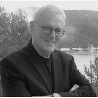
Obituary: Karl Kenny, Founder, Kraken Robotics
against the bigger industry players,” said Greg Reid, President and CEO of Kraken Robotics. “He was an incredible force that drove Kraken to success. On behalf of the Board of Directors, management and employees, he will be sorely missed.”Karl grew up in a small fishing village in Newfoundland with a deep connection to the sea. Over his 45-year career in the marine technology industry, he led the development of a wide range of advanced marine technologies and products in Canada, the United States, and Europe. Karl spent time as a maritime surface officer with the Canadian Navy


