From Uncertainty to Advantage: WHOI Launches New Initiatives for Industry Partners
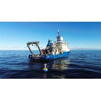
use.Through OceanWorks and Ocean IQ, partners gain direct access to these capabilities through targeted projects, shared research, and long-term collaboration focused on generating evidence and improving performance.Space-based systems help collect, transmit, and integrate ocean observations, linking remote sensing with real-time analytics and operational decision-making. © NASATalent Built for UncertaintyBeyond tools and data, WHOI’s value lies in its people. That value comes from an integrated workforce that brings together scientists, engineers, marine crews, advanced fabrication and machine
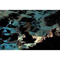
PML: 20 Years of Data Shows Declining Ocean Productivity Around UK
the patterns they have discovered in the North-East Atlantic are similar with other parts of the Atlantic Ocean. “With continued satellite monitoring, we can better track how climate change is reshaping ocean productivity and identify regions most at risk,” said Dr Peter Land, Remote Sensing Scientist at PML. “That knowledge is essential for managing marine ecosystems in a changing climate.” The study provides one of the most detailed regional assessments to date of long-term changes in ocean productivity in the north-east Atlantic, which includes the western English
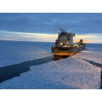
Breaking the Ice: How a Space-Based Initiative is Solving a Maritime Challenge
;s economic diversification strategy. The Michigan Office of Defense and Aerospace Innovation (ODAI) hosted the 2025 MiSpace Hackathon in the fall of 2025, drawing more than a hundred Michigan-based undergraduate students to use space-based data to predict Great Lakes ice packs.Satellite and remote sensing data are becoming increasingly accessible, transforming how we tackle terrestrial problems. In 2025 alone, approximately 10,000 satellites were launched globally, each designed to sense our environment in unique ways, capturing everything from soil moisture and infrared heat signatures to hyperspectra
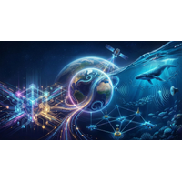
Taking Quantum Logic to the Edge
large-scale sensing and modeling.Entanglement and AOS have already created a new company, Maritech Intelligence Systems, which launched with two foundational product platforms:MIST™ (Maritime Information Synthesis Terminal) — a living digital twin of the world’s oceans that fuses remote sensing, in-situ sensors, and quantum-logic-enabled AI. Built on decades of ocean acoustic research and real-world deployments, MIST delivers real-time maritime awareness, prediction, and targeting with unmatched precision—globally, continuously, and in context.MADEN™ (Maritime Autonomous
University of Plymouth Joins Seabed 2030
Seabed 2030’s goal of inspiring a complete map of the world’s ocean through various initiatives, including the contribution of new bathymetric data and satellite-derived bathymetry.The partnership will also see advances in research and innovation in the fields of hydrography, autonomy and remote sensing in order to improve seafloor mapping efforts. Additionally, it supports the University’s commitment to training the next generation of hydrographers and seafloor mappers through its esteemedSeabed 2030 is a collaborative project between The Nippon Foundation and the General Bathymetric
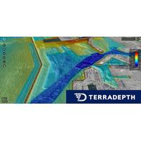
Terradepth Achieves IHO Special Order Standard for Seabed Mapping Accuracy
stringent international standards for hydrographic accuracy. The survey took place in approximately 80 meters of water, 60 miles offshore in the Gulf of America, a region affected by hurricanes and subsea infrastructure development. Despite the absence of local tide stations or buoys, European Remote Sensing (ERS) satellite radar was used to correct for tidal variations, demonstrating a fully autonomous and low-logistics survey approach.The IHO S-44 Special Order standard relates to areas where underkeel clearance is critical. Therefore, 100% feature search and 100% bathymetric coverage are required

Schmidt Sciences Awards $45M to Carbon Cycle Research
observing missions in the Southern Ocean.Rapid Permafrost Thaw Carbon Trajectories (PeTCaT)Led by: Guido Grosse, Alfred Wegener Institute, GermanyPeTCaT will quantify the impact of permafrost thaw in Arctic and Boreal ecosystems on greenhouse gas budgets globally, using field and lab studies, remote sensing, deep learning and Earth system modeling to examine the vulnerability of Earth’s largest land carbon pool
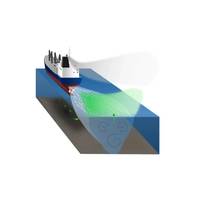
Study: Ships Trigger Ocean Methane Emissions
."The discovery of the hitherto unknown impact of ships is important for improving global estimates of methane emissions, not least considering that nine of the world's 10 largest ports are located in waters with similar conditions as Neva Bay," says Johan Mellqvist, Professor of Optical Remote Sensing, Chalmers, whose group made the unexpected discovery that forms the basis for the new results.Two of the largest ship types, cruise and container ships, triggered the most frequent and largest measured methane releases, but slightly smaller ropax vessels (combined freight and passenger ferries)
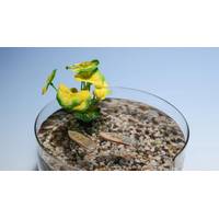
Edible Aquatic Robot Could Collect Environmental Data
polymers and electronics.The EPFL team plans to deploy the robots in large numbers. Each device would be equipped with biodegradable sensors to collect environmental data such as water pH, temperature, pollutants and the presence of microorganisms, which could be read after collection or via remote sensing.The work is the latest innovation in the burgeoning field of edible robotics and robotic feeding. The Intelligent Systems Laboratory has previously published several papers on edible devices, including edible soft actuators as food and pet food manipulators, edible control circuits and edible


