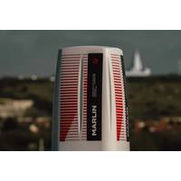
RS Aqua Launches Marlin Acoustic Monitoring System
with alerts delivered directly to end users. Its modular, scalable architecture supports both fixed and mobile deployments and is compatible with NATO STANAG protocols.With integrated 4G as standard and plug and play options including 5G, Starlink, point-to-point radio and Iridium satellite communications, Marlin is built to operate wherever the mission demands.Marlin has been developed to support a wide range of applications, from real-time marine environmental monitoring and long-term ecological research to remote asset surveillance and security-critical maritime operations
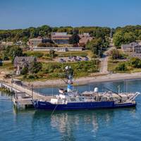
Retiring the R/V Endeavor: Celebrating a Lifetime of Accomplishments and Memories
capability wise, if you stepped on Endeavor today, after 50 years of service, you would never know that it's a 50-year-old ship. We worked very hard to keep it up to date. We're constantly installing new equipment. In the last five or six years, there's been huge advances in satellite communications and cybersecurity, and we're a leader in that regard," Gruebel added.New era, new DawnAs Endeavor heads into retirement, URI is planning for its new vessel, R/V Narragansett Dawn, which at time of writing is under construction in Houma, Louisiana, and will be delivered in March
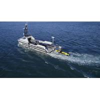
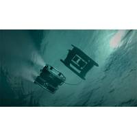
Kraken Robotics, TKMS ATLAS UK Demonstrate KATFISH USV Launch and Recovery System
was demonstrated off the coast of Portland, UK, November 18-19, for NATO navies. Attendees witnessed the ARCIMS USV autonomously navigate and plan missions with the KATFISH towed system collecting high resolution SAS and bathymetric surveys in very shallow water. Data was live streamed via satellite communications to the command center on shore, enabling real-time classification of contacts by operators.Kraken’s KATFISH being deployed by the USV-LARS system. © Kraken RoboticsKraken’s KATFISH collects high resolution synthetic aperture sonar data at up to a 200-meter range per side
ESA, UK Space Agency Back ACUA Ocean’s Subsea Inspection Robotics System
vessel (USV) capabilities to launch and recover (LAR) remotely operated vehicles (ROVs).The ‘nested robotics’ approach - or robots deploying other robots - aims to expand the operational scope of uncrewed systems in offshore energy and subsea inspection.The system will use multiple satellite communications (satcom) solutions along with GNSS to enable Beyond Visual Line of Sight (BVLOS) remote control, positioning, and data transfer for both the USV and the tethered ROV.Network bonding technology will allow PIONEER to use the bandwidth of all available connections simultaneously rather than
CSA Ocean Sciences Expands Remote Monitoring Capabilities
poised to transform the way seafloor imagery is analyzed, providing technology-driven, cost-effective, and near real-time methods that complement traditional field operations.Subsea video is crucial to identifying benthic habitats and hazards in a range of offshore projects. Using vessel-based satellite communications and video routing, CSA subject matter experts (SMEs) can monitor subsea video 24/7 from shore-based locations. Live video is transmitted from the vessel to any one of CSA’s international offices, where cross-disciplinary SMEs can analyze imagery and communicate with the offshore team
OceanAlpha USV Validates Long-Range Survey Capability in Malaysia
USV directly addressed a critical constraint for offshore marine surveys: crew dependence and costly support vessels typically required for operations beyond line-of-sight (LOS) control range. By successfully conducting a survey mission 33 kilometers offshore while maintaining continuous, stable satellite communications and real-time payload data transmission, the L25 validated reliable Over-the-Horizon (OTH) capability essential for large-scale or remote survey areas.In the congested waters of Port Klang, the vessel’s perception systems enabled autonomous navigation around moored vessels while dynamically
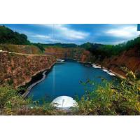
Teledyne Marine autonomously surveys DEEP's quarry lake in Wye Valley
onboard winch enabled remote deployment, and near real-time profiler data was accessible via smartphone for immediate quality control.The electric Otter Pro vessel, launched via crane, operated both locally and remotely. During surveyor breaks, operators in Norway controlled the vessel through satellite communications, leveraging its onboard cameras and collision avoidance radar to navigate autonomously. The survey produced high-quality data, covering nearly the entire body of water in a single pass
USV Hypoxia Mapping Capabilities Verified by Manned Vehicle
and satellite connections to servers at USM for real-time quality assurance.Simultaneously, USM and NOAA collected data via a crewed vessel along several sampling sites to compare and validate data collected by the SP-48.The SeaTrac SP-48 USV was configured with a deep keel and redundant satellite communications for offshore operations. It was fitted with an AML-3 Sonde (with wireless charging capabilities) as well as conductivity, temperature, depth (CTD) and dissolved oxygen (DO) sensors. Auxiliary sensors for additional data collection included the Teledyne Workhorse Monitor 300 kHZ ADCP, SeaView
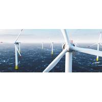
Using Ocean Robots to Dive into Offshore Wind Farm Wake Effects
low-powered, using changes in buoyancy and their fins, to see-saw through the water column or months on end at depths down to 1,000m.This starts on pre-programmed routes, but because they reach the surface every few hours, they can be given different missions by scientists on shore via satellite communications.For this project, two were deployed from Arbroath to head out and patrol the area being studied, an area roughly 70m deep in the Firth of Forth, from April to August 2023, and then from June to August this year.Low Power, but Packed with SensorsDespite their small size and low power use