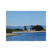
Eyesea and SalmonChile Successfully Complete Patagonia Coastal Waste Monitoring Pilot Using Satellite Spectrometry
Eyesea, in partnership with environmental consultancy Paz Recycling, has concluded a pilot program to monitor and manage coastal waste in Patagonia using satellite imagery and artificial intelligence. The initiative, launched as part of SalmonChile’s open innovation challenge Observatorio de Playas, aims to enhance coastal surveillance and optimize cleanup operations.Through field visits, data calibration, and satellite analysis provided by Eyesea, Paz Recycling, SalmonChile, and sustainability consultancy, Këtrawa validated a system that detects and tracks waste accumulation in
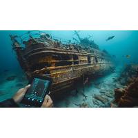
Billions in Lost Treasure: How Modern Technology Is Revealing Hidden Riches from the Depths!
one of the world's most valuable unrecovered treasures. Although located by Colombian officials in 2015, most of her treasure has to be recovered due to legal disputes regarding ownership.Today, Technological innovations like sonar, underwater drones, remote operated vehicles (ROVs), and satellite imagery have revolutionized deep-sea exploration allowing treasure hunters to reach depths once inaccessible for exploration of wrecks or reefs that hold riches buried within.Side-scan sonar is one of the primary tools used in searching for shipwrecks, providing researchers with detailed images of
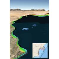
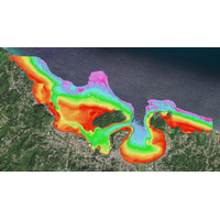
Satellite-based Solution Helps to Prevent Ship Groundings in Coastal Waters
precise water depth measurements in near-shore areas.“While the exact causes of recent ship groundings off the coasts of Oman, Greenland, and Fiji are under investigation and often complex, the risk of such accidents can be significantly reduced with up-to-date bathymetric data produced from satellite imagery,” said TCarta President Kyle Goodrich. “Often in coastal areas, the regions outside commercial shipping lanes are poorly charted or not surveyed.”Traditionally, obtaining high-quality water depth measurements in shallow coastal waters has been both costly and hazardous, particularl
Students Spend Summer Mapping Seafloor for Seabed 2030
Foundation-GEBCO Seabed 2030 Project, which aims to inspire the complete mapping of the seafloor by 2030.The bathymetry was generated for the coastlines of Somalia, the Mosquito Coast, the Galapagos and the islands of the Lesser Antilles.During the summer, the students were introduced to a range of satellite imagery options and learned to evaluate the strengths of each for various project applications. TCarta provided training on using a pre-processing tool to prepare in situ data from sonar or Lidar, which served as calibration datasets for processing satellite images. Additionally, the students were

PODCAST: “All in the [Gallaudet] Family”
that career path in the Navy is you get exposed to ocean technologies from the very beginning. Even at the Naval Academy, we were using side-scan sonar to do surveys and collect data in the Chesapeake Bay.My first tour was going to graduate school at Scripps where I worked with multibeam sonar and satellite imagery. I went on a few cruises on a couple of Scripps ships, and then I immediately deployed to the Arabian Gulf and worked on a hydrographic survey ship, towing side-scan sonar and operating multibeam sonar, and using other types of collection equipment like conductivity, temperature and depth profilers
TCarta Plans Bathymetric Mapping Workshop for Jamaica
expertise, so that we can use these tools more flexibly.”This year’s workshop seeks to produce SDB maps of the entire coastal area of Jamaica, including the environmentally and economically important Pedro Cays. Participants will extract seafloor depth data from multispectral Sentinel-2 satellite imagery and use NASA ICESat-2 LiDAR data for validation. The resulting data sets will include water depth measurements at 10-meter resolution to an average depth of 20 meters.“The 2024 workshop will be led by hydrographers from TCarta’s Colorado and Jamaica offices,” said Goodrich
U.S. Revives Cold War Submarine Spy Program to Counter China
reviewed hundreds of Navy contracts. That examination identified at least 30 deals linked to the surveillance program signed over the last three years with defense giants as well as a string of startups working on unmanned sea drones and AI processing. A Reuters review of ship-tracking data and satellite imagery also revealed new details about the Navy’s secretive underwater cable laying.The IUSS is led by Captain Stephany Moore, a veteran Navy intelligence officer. The program operates under the command of Submarine Force U.S. Pacific Fleet, headed by Rear Admiral Richard Seif.Moore and
Inside the Subsea Cable Firm Secretly Helping America Take on China
;s home to a discreet U.S. naval base.Over the next month, the ship’s crew covertly laid an underwater fiber-optic cable to the military base, an operation code-named “Big Wave,” according to four people with direct knowledge of the mission, as well as a Reuters analysis of satellite imagery and ship tracking data.The new super-fast internet link to Diego Garcia, which has not previously been reported, will boost U.S. military readiness in the Indian Ocean, a region where China has expanded its naval influence over the last decade.The CS Dependable is owned by SubCom, a small-town
TCarta to Deliver Satellite Derived Bathymetry for 13 Regions
and seafloor classification data for the coastal zones of 13 regions around the world to the National Geospatial-Intelligence Agency (NGA) under contract to Maxar Technologies.TCarta will deliver seabed depth and feature maps from high-resolution multispectral Maxar WorldView-2 and WorldView-3 satellite imagery for the 13 regions. SDB measurements are accurate to depths of 20-30 meters depending on water conditions, with two-meter spatial resolution. Feature classification includes coral reefs, large rocks, sandbars and other navigation hazards.TCarta has processed thousands of Maxar satellite images


