TCarta to Deliver Satellite Derived Bathymetry for 13 Regions
TCarta Marine won a contract to deliver satellite derived bathymetry (SDB) and seafloor classification data for the coastal zones of 13 regions around the world to the National Geospatial-Intelligence Agency (NGA) under contract to Maxar Technologies.
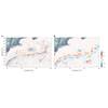
TCarta will deliver seabed depth and feature maps from high-resolution multispectral Maxar WorldView-2 and WorldView-3 satellite imagery for the 13 regions. SDB measurements are accurate to depths of 20-30 meters depending on water conditions, with two-meter spatial resolution. Feature classification includes coral reefs, large rocks, sandbars and other navigation hazards.
TCarta has processed thousands of Maxar satellite images for the project, including hundreds of high-resolution scenes for one nation alone. By the time all deliverables have been submitted and approved by NGA, TCarta will have mapped the entire subsurface coastlines of the 13 regions over the 12-month Period of Performance.