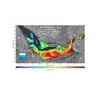
Satellites Help NOC Track Tidal Change for Safer Port Operations
strategies," said Russell Bird, Deputy Group Harbour Master (Hydrographic and Dredging), at Peel Ports Group. "The findings that NOC has achieved has showed us the potential to manage significant changes in the river more proactively.”The project analyzed data from optical and radar satellite images combined with information from the Gladstone Tide Gauge, which sits within the Old Lock Keeper's Office at the entrance to Gladstone Dock, in Liverpool. These were further combined with fine scale water level data from the new Surface Water and Ocean Topography (SWOT) satellite, launched
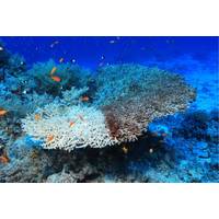
The Future of Coral Reef Protection
led by the University of South Australia is integrating remote sensing technologies with machine learning, AI and Geographic Information Systems (GIS) to monitor the damage.A multimodal platform will distil all research data relating to coral reefs, including underwater videos and photographs, satellite images, text files and time-sensor readings, onto a central dashboard for real-time global monitoring.The researchers say an integrated system will track bleaching severity and trends over time; monitor crown-of-thorns starfish populations and predation risks; detect disease outbreaks and juvenile
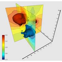
Golden Software updates Surfer Mapping Tech
Golden Software added the ability to download georeferenced Google aerial and satellite images to map projects in the latest version of its Surfer mapping and 3D visualization package. Other new features focus on faster and simpler creation of 3D visualizations that are easier to interpret and understand.Surfer enables users to model data sets, apply an array of advanced analytics tools, and visually communicate the results in a way that even the non-technical stakeholders can understand. Surfer is used by more than 100,000 people worldwide, many involved in environmental consulting, water resources
Integrated Data System for Coral Reefs Enables AI Analysis
and Victorian researchers, is integrating remote sensing technologies with machine learning, AI and Geographic Information Systems (GIS) to monitor and hopefully stall the damage.A multimodal platform will distil all research data relating to coral reefs, including underwater videos and photographs, satellite images, text files and time-sensor readings, onto a central dashboard for real-time global monitoring.Lead researcher Dr Abdullahi Chowdhury says that a single centralised model will integrate all factors affecting coral reefs and provide environmental scientists with real-time predictions.“At
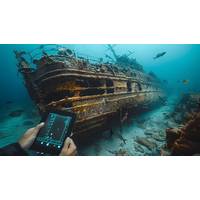
Billions in Lost Treasure: How Modern Technology Is Revealing Hidden Riches from the Depths!
combined with sonar systems, treasure seekers can pinpoint exact locations of sunken vessels.Satellite technology has also become an invaluable asset when it comes to treasure hunting, offering clues as to where wreckage or debris fields have moved over time. Some treasure hunters use historical satellite images of hurricanes or storms which might have caused ships to sink - further narrowing search areas.Treasure-Rich Waters Around the World Certain regions of the world's oceans are notoriously abundant with treasure-filled wrecks, drawing the interest of treasure hunters and marine archaeologists
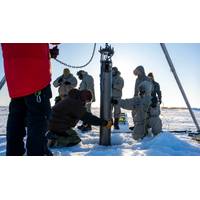
Rocket Scientists Build Antarctic Robot Probes
global sea levels by an estimated 200 feet (60 meters).Ice shelves, floating slabs of frozen freshwater extending miles from the land into the sea, take thousands of years to form and act like giant buttresses holding back glaciers that would otherwise slide off easily into the surrounding ocean.Satellite images have shown the outer "calving" off into icebergs at a higher rate than nature can replenish shelf growth.At the same time, rising ocean temperatures are eroding the shelves from underneath, a phenomenon scientists hope to examine with greater precision with the submersible IceNode
Students Spend Summer Mapping Seafloor for Seabed 2030
students were introduced to a range of satellite imagery options and learned to evaluate the strengths of each for various project applications. TCarta provided training on using a pre-processing tool to prepare in situ data from sonar or Lidar, which served as calibration datasets for processing satellite images. Additionally, the students were taught how to apply an enhanced version of a traditional band ratio algorithm alongside a machine learning algorithm in iterative processes to derive water depth measurements from individual image pixels
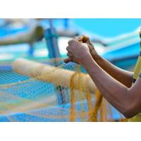
Indian Fishermen Use Smartphones to Map a Vanishing Way of Life
. The sea, the river – which were sources of our livelihood - are polluted in the process,” Saravanan said.Saravanan opened his laptop and pulled up the GIS software he uses to map hundreds of villages in his area, cross-checking the sites designated by fishermen such as Raji against satellite images of the entire area.Saravanan said he learned how to use the software from a friend who had studied software engineering and from YouTube.Next he recruited statewide volunteers to map the land.“The technology is the same [as what the government uses] ... it’s just that they don&rsquo
Inside the Subsea Cable Firm Secretly Helping America Take on China
.SubCom’s CS Reliance vessel laid the first half of the commercial cable from Perth, Australia, to the middle of the Indian Ocean. From there, the CS Dependable took over, running the splice to Diego Garcia and laying the rest of the main trunk up to Oman, the people said.Reuters analyzed satellite images and ship tracking data on Eikon, the financial analysis platform owned by the London Stock Exchange Group. That information showed the CS Dependable operating around Diego Garcia in February and March of 2022, then sailing on to Oman.The delicate operation was made possible by a decades-long


