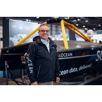
CTO in Focus: “Stop, Listen & Think” - One-on-One with Shepard Smith, XOcean
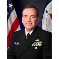
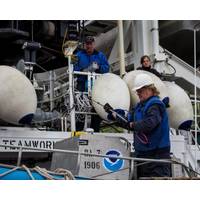
side; and I was the chief of our charting division. I finished my career as the Director of the Office of Coast Survey and the U.S. National Hydrographer. Some of my most memorable times were the 10 years that I spent at sea, including four years as the commanding officer of the NOAA Ship Thomas Jefferson. But through it all, I was driving toward bringing new technology to improve the science and art of hydrography at sea.Before we dive into your new role at XOcean, I’d like to get a little background on the ocean exploration market, as you see it. What technologies do you count as to have

Shep Smith Appointed XOCEAN CTO
to the rank of Rear Admiral and was closely involved in advancing state-of-the-art hydrography and nautical cartography.His 10 years of working at sea included tours in Alaska, the Pacific, and the Atlantic and Gulf coasts and four years as the Commanding Officer and Chief Scientist of the NOAA Ship Thomas Jefferson. In his final role with NOAA, he served as Director of the Office of Coast Survey, where he oversaw the US national programs in hydrography and nautical cartography. Smith also represented the United States at the International Hydrographic Organization and regional hydrographic commissions
Meet LT Laura Dwyer: NOAA Officer, Navy Oceanographer
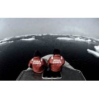
and internationally, participating in exercises in San Diego; Anchorage; Panama City Beach, FL; San Clemente Island, CA; Gulf of Mexico, MS; Kingdom of Bahrain; South Korea; and Spain."NOAA Corps, one of the seven uniformed services of the United States, traces its roots to 1807 when President Thomas Jefferson created a new federal agency whose mission was to chart the nation's coastal waters to ensure that ships could move civilians, troops, and materiel safely. NOAA Corps Officers work on land, in the air, and on the sea providing products and services that support maritime domain awareness
NOAA Releases 2018 Hydrographic Survey Plans
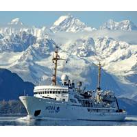
Beginning in April, NOAA’s four hydrographic survey ships – Thomas Jefferson, Ferdinand Hassler, Rainier and Fairweather – will set out along with private contractors to tackle their assigned survey projects over the course of the 2018 field season. Below are NOAA’s priority areas for planned survey projects 2018: Alaska North Coast of Kodiak Island – Last surveyed in 1932, this survey project focuses on areas inadequate for safe navigation, particularly along the corridor of vessel traffic transiting from Kodiak. West of Prince
Smith Named Director of NOAA Coast Survey
." Smith has served with NOAA for 23 years, during which time he has been deeply involved in advancing the state-of-the-art in hydrography and nautical cartography. His 11 years as a field hydrographer continue to this day, as he currently serves as the commanding officer of NOAA Ship Thomas Jefferson. He previously served as the chief of Coast Survey's Marine Chart Division, managing the privatization of paper chart printing and distribution. In addition to his three tours on Thomas Jefferson (twice as her commanding officer), Smith also served on NOAA Ship Rainier, surveying in
Willard to Build 3 Survey Ships for NOAA
engine capable of 510 HP with a ZF Marine 305-2 transmission will be used to power the boats. Outfitted to support traditional manned survey operations, the HSLs will offer additional flexibility to add unmanned autonomous capability. Two Willard Marine HSLs will be built for the 208-foot NOAA ship Thomas Jefferson, and an additional Willard Marine HSL will be built for the 231-foot NOAA ship Rainier. Using advanced sonar technology, the crews of the Thomas Jefferson and Rainier conduct hydrographic surveys for the primary purpose of updating NOAA’s suite of nautical charts
NOAA Deploys Survey Ships for Arctic Charting Projects
update its navigational charts, as laid out in its Arctic Nautical Charting Plan. The marine corridor project will also provide information to help the Coast Guard assess the safety of the proposed USCG port access route. NOAA’s Office of Coast Survey, originally formed by President Thomas Jefferson in 1807, maintains the nation’s nautical charts, surveys the coastal seafloor, responds to national maritime emergencies, and searches for underwater obstructions and wreckage. NOAA ships Rainer and Fairweather are part of the NOAA fleet of research ships operated, managed and
NOAA to Boost Arctic Nautical Charting
discovered by NOAA cartographers and researchers using commercial satellite imagery. Fairweather is scheduled to survey Port Clarence, a key Bering Strait location that is of potential interest as an Arctic deepwater port. NOAA’s Office of Coast Survey, originally formed by President Thomas Jefferson in 1807, maintains the nation’s nautical charts, surveys the coastal seafloor, responds to national maritime emergencies and searches for underwater obstructions and wreckage. NOAA ships Fairweather and Rainier are part of the NOAA fleet of research ships operated, managed and
NOAA Orders Newbuild Navigation Response Boats
and docking at the Statue of Liberty after Sandy, and surveyed the Potomac River security zone in preparation for the 2013 Presidential Inaugural. Nautical chart data acquired by the navigation response teams supplement hydrographic surveys conducted by NOAA ships Rainier, Fairweather, Thomas Jefferson, Ferdinand R. Hassler, and research vessel Bay Hydro II, as well as private survey companies under contract to NOAA. noaa.gov