Curtin, NASA Tap Ocean Information from Space
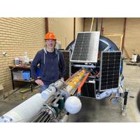
Curtin University has joined forces with NASA, University of Miami, San José State University and the National Institute of Standards and Technology on a new-generation satellite mission to study the colour of the ocean from space, providing vital information about ocean health and its role in climate regulation.Researchers recently deployed a 15-metre-tall buoy off the coast of Perth, Western Australia, as part of a new project to ensure the data quality for NASA’s newly launched PACE (Plankton, Aerosols, Clouds, Ocean Ecosystems) satellite mission.Professor David Antoine, head of
NOAA Awards $2.1 Million for Ocean Exploration Projects
Zone and NOAA’s science and technology priorities.Three of the supported projects are described below , and NOAA said the fourth will be announced a a later date.Characterizing Mesophotic Fish Assemblages of Puerto Rico’s Western EEZ - (Principal Investigator: Richard R. Coleman, University of Miami)Mesophotic (“middle light”) coral ecosystems provide habitat for an array of vulnerable and ecologically and commercially important fish species. At ocean depths between the brightly lit shallows and the dark deep ocean (30-150 meters/98-492 feet) in tropical and subtropical regions
US Awards $6.7 Million for Sea Level Rise and Coastal Resilience Research
Pacific Northwest.(IRA-funded) University of Georgia, U.S. Geological Survey and Embry-Riddle Aeronautical University received $500,000 to model nature-based flood mitigation projects to inform holistic coastal planning in the Gulf of Mexico coast.(IRA-funded) University of California, Irvine and University of Miami received nearly $500,000 to evaluate how nature-based solutions can empower more equitable flood risk management in Los Angeles County, California.(IRA-funded) George Mason University, The Nature Conservancy, Resources for the Future and Maryland Department of Natural Resources received nearly
Researchers Study the Fast Gulf Stream Currents
supported by the Natural Environment Research Council (NERC) and the US National Science Foundation (NSF). Researchers from the National Oceanography Centre, the University of Southampton, the University of Liverpool, the Scottish Association of Marine Science, the British Antarctic Survey and the University of Miami are involved in this project
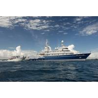
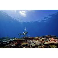
Largest Coral Reef Survey and Mapping Expedition Completed
maps and surveys make up the most comprehensive standardized data set yet collected for coral reefs.“The Global Reef Expedition was a monumental achievement,” said Sam Purkis, KSLOF’s Chief Scientist as well as Professor and Chair of the Department of Marine Geosciences at the University of Miami’s Rosenstiel School of Marine and Atmospheric Science. “It owes its success to nimble planning and a common vision shared by a broad group of forward-thinking scientists, managers, and educators. I have no doubt that the baseline determined by the GRE for the world’s reefs
NASA, KSLOF Partner to Fast-track Coral Reef Mapping
undertaking. We were inventing the technology as we went, pioneering new ways to map coral reefs using satellite imagery and verified with data taken in the field,” said Sam Purkis, KSLOF’s Chief Scientist as well as Professor and Chair of the Department of Marine Geosciences at the University of Miami’s Rosenstiel School of Marine and Atmospheric Science. Purkis led the Foundation’s coral reef mapping efforts on the Global Reef Expedition and is excited to see NASA use the Foundation’s data to take coral reef mapping to the next level. “This is a game-changer
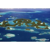
Coral Reef Health Report: Palau’s Coral Reefs - A Jewel of the Ocean
, this longterm commitment to marine conservation has delivered some of the most vibrant reefs the Foundation encountered on its Global Reef Expedition,” said Dr. Sam Purkis, KSLOF’s Chief Scientist as well as Professor and Chair of the Department of Marine Geosciences at the University of Miami’s Rosenstiel School of Marine and Atmospheric Science.“Given that Palau’s efforts are yielding tangible conservation results, the country might serve as a role model to other countries in the South Pacific and beyond.”Despite a thriving coral community, Palau&rsquo
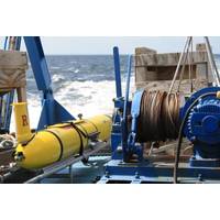
Measuring the Hostile Ocean Beneath Hurricanes
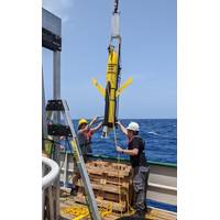
, the EM-APEX floats must be deployed at short notice ahead of moving storms; thus, they are air-dropped by parachute from aircraft. When hurricane Michael entered the Gulf of Mexico in October 2018, three EM-APEX floats were launched into its path by a research team led by Professor Nick Shay (University of Miami). Air deployment was from a USAF WC-130J Hercules aircraft operating from the Keesler Air Force base; these planes are modified for collecting weather information in hurricanes. Several US government agencies that monitor and predict hurricanes helped with the air deployment. Teledyne Marine
MTS Welcomes Two New Board Members
and private—and research institutes and helps develop opportunities for students.Miller earned his B.S. in Marine Science from the University of South Carolina, his M.S. in Oceanography from the University of Rhode Island, and his Ph.D. in Meteorology and Physical Oceanography from the University of Miami. He is the president of Science for Decisions, a consulting practice which he founded in 2013 to ensure that solid science is available to inform decisions that impact people and places around the globe.Miller also served from 2015 through early 2017 as Director of the Science and Technology


