
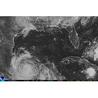
Where Are the Hurricanes? Quiet Atlantic Bucks Forecast for 'Super' Season
supportive for later-season hurricanes.The two most active hurricane seasons on record, 2020 and 2005, featured cool Pacific Ocean temperature anomalies similar to those currently in place. Storm development was very frequent between September and November in both of those years.As of Thursday, the U.S. National Hurricane Center had identified five areas of disturbance in the Atlantic, more than would normally occur simultaneously.Those are not forecast to produce much at all in the way of hurricanes, but it may be a sign that the ingredients are present and a flurry of storms could be ignited should the

Weakened Maria Could Regain Major Hurricane Status -NHC
Maria, which weakened into a Category 2 hurricane on Wednesday, could regain major hurricane status by Thursday, the U.S. National Hurricane Center (NHC) said in its latest advisory. Catastrophic flash flooding was occurring over portions of Puerto Rico with conditions now deteriorating over the eastern Dominican Republic, the NHC said. The hurricane was about 25 miles (45 km) north northwest of Aguadilla, Puerto Rico with maximum sustained winds of 110 miles per hour (175 km per hour), the Miami-based NHC said. Any hurricane with top sustained winds of at least 111 is classified as
Hurricane Franklin Nearing Mexico
Franklin, upgraded to a Category 1 hurricane from a tropical storm, is expected to hit eastern Mexico's key oil-producing Gulf state of Veracruz on Wednesday evening or early Thursday morning, the U.S. National Hurricane Center said on Wednesday. Franklin, the first hurricane of the Atlantic's season, was packing maximum sustained winds of 75 mph (120 km/h) and was about 105 miles (170 km) northeast of Veracruz, Mexico, the Miami-based weather forecaster said. "Some additional strengthening is expected until the center crosses the coast (in the Mexican state of Veracruz). Rapid
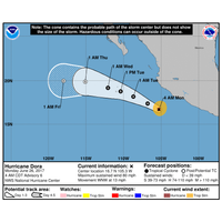
Hurricane Dora Forms Off Mexico's Pacific Coast
Hurricane Dora formed off the western coast of Mexico in the Pacific Ocean on Monday, but it was expected to slow and remain offshore, the U.S. National Hurricane Center (NHC) said. Dora, the first hurricane to form in the Pacific so far this year, was carrying maximum sustained winds of about 80 miles per hour (130 km per hour) as it whirled about 170 miles (275 km) south-southwest of the port of Manzanillo, the center said. Dora was slowing and was likely to see some strengthening on Monday before weakening on Tuesday, the NHC said. The storm was expected to drop 1 to 2 inches (25 to 50 mm) of
Hurricane Joaquin Continues to Strengthen
Joaquin, the third hurricane of the 2015 Atlantic season, continues to strengthen and is likely to develop into a major hurricane in the next couple of days as it moves toward the Central Bahamas, the U.S. National Hurricane Center said on Wednesday. Joaquin, now a Category 1 hurricane, is located about 190 miles (305 km) east-northeast of the Central Bahamas with maximum sustained winds of 85 miles per hour (135 km/h), the latest advisory said. "A turn toward the northwest and a decrease in forward speed are forecast by Thursday or Thursday night" the Miami based weather
Tropical Storm Erika Heads for Florida
Tropical Storm Erika lashed Puerto Rico and the Virgin Islands with heavy rain and fierce winds on Friday, moving across the Caribbean and apparently heading for the Dominican Republic, northern Haiti and eventually South Florida, the U.S. National Hurricane Center said. Due to some likely weakening over the Dominican Republic, Erika was no longer forecast to make U.S. landfall as a hurricane. It could still smack the Miami area with sustained winds of 60 miles per hour (97 kph) on Monday, however, before sweeping northward up the Florida peninsula, affecting Orlando's popular theme parks.
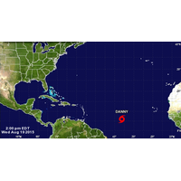
Danny Strengthens into First Hurricane of 2015 Atlantic Season
Danny became the first hurricane of the 2015 Atlantic season on Thursday even as the storm remained relatively small and far from affecting any land, according to the U.S. National Hurricane Center. Winds from Danny were gusting up to 75 miles per hour (120 kph), government forecasters said, just attaining hurricane status of at least 74 mph (120 kph) winds. Danny was projected to weaken back into a tropical storm before reaching Puerto Rico on Tuesday morning, according to the Miami-based hurricane center's five-day outlook. "Danny is a small tropical cyclone,"
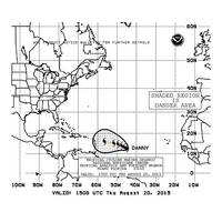
Atlantic May See First 2015 Hurricane, 'Danny' Strengthens
Tropical Storm Danny is on track to become the first hurricane of the 2015 Atlantic season by Friday and could approach the Caribbean islands by the late weekend, the U.S. National Hurricane Center said on Wednesday. It is still too early to predict whether Danny, currently a tropical storm with winds gusting up to 50 miles per hour (85 kph), will impact the United States, said Dennis Feltgen, a meteorologist and spokesman for the hurricane center in Miami. Danny is the fourth named storm of what is expected to be a quieter-than-normal Atlantic hurricane season, he said. Earli
Tropical Storm Forms Off US Mid-Atlantic Coast
Tropical storm Claudette, the third named tropical storm of the 2015 Atlantic season, formed east of the mid-Atlantic coast, the U.S. National Hurricane Center said on Monday. Claudette was located about 290 miles (465 kilometers) south-southeast of Nantucket, Massachusetts and was packing maximum sustained winds of 50 miles per hour (85 km/h), the Miami-based weather forecaster said. Claudette was moving towards the northeast near 15 mph (24 km/h) and is not expected to be a threat to the United States, the NHC said. (Reporting by Nallur Sethuraman and Vijaykumar