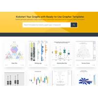
Golden Software Makes Upgrades Grapher Scientific Package with Enhanced Templates
Golden Software, a developer of mapping, plotting, and visualization software, has enhanced the Template experience in its Grapher scientific graphing package with improved ease of use and an online Template library. The completely redesigned Template functionality streamlines data preparation, analysis, and graphing for Grapher users at every level.Grapher enables users to make better decisions by visualizing and communicating complex data sets in ways that simply can’t be accomplished with spreadsheets. Enhancements in the latest release of Grapher gives users faster and deeper insights into
Oceaneering Expands Vision Platform with Subsea Module for Engineering‑Grade Integrity Visualization
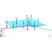
Oceaneering International, Inc. announced Vision Subsea, a new module within the cloud‑based Vision 3D data visualization software platform developed by GDi, an Oceaneering company. The module presents engineering-grade point cloud data generated during ROV operations, giving engineers a measurable, contextual view of subsea asset integrity to better enable identification of anomaly location, dimensional checks, and intervention planning.The module addresses common integrity challenges from fragmented drawings and reports to video lacking spatial context, by consolidating inspection evidence into
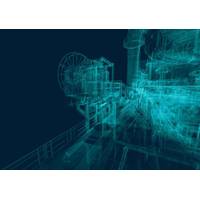
Golden Software Expands 3D Drillhole Visualization, Overall Usability in Surfer Mapping Package
Golden Software has continued to enhance the 3D drillhole viewing functionality in the latest release of its Surfer mapping and 3D visualization software package. Overall, the new version of Surfer provides users with several upgrades to save time and streamline creation of subsurface maps.Surfer is used by more than 100,000 people worldwide, many involved in environmental consulting, water resources, engineering, mining, oil & gas exploration, and geospatial projects. Surfer enables users to model data sets, apply an array of advanced analytics tools, and visually communicate the results in a way
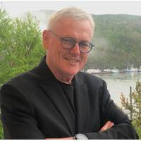
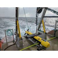
Ocean Influencer: Karl Kenny, Kraken Robotics
KATFISH, an intelligent towed SAS system capable of acquiring over 3 billion pixels per 3km2 per hour of area coverage rate. The KATFISH system is comprised of an actively controlled smart towfish, SAS imaging, bathymetry and gap-filler sonars, launch and recovery system, operator console, and visualization software

Drone Specialist Cyberhawk Lands 5-Year Deal with Shell
Drone-based inspection company Cyberhawk has said it has signed a five-year, multimillion-dollar software contract with oil giant Shell.Under the contract, Cyberhawk will provide its cloud-based asset visualization software iHawk for all onshore, offshore, and subsea assets, as well as all global construction projects."The contract follows the successful integration of iHawk at a construction project valued at over $6bn in the USA, where it is now being used by over 800 monthly users and has been rolled out at further sites in the UK, Central America, and Africa," Cyberhawk said.Cyberhawk
Meet the Future of Visualization and Mapping Sonars
models to enhance and visually augment the acoustic sonar data, the ability operate with and without GNSS position and motion data and the ability to export raw or binned point-cloud data for processing in third-party hydrographic software. We have further developed our proprietary visualization software to add the ability to track targets for the breakwater construction market and our construction specific software CMS. This unique software enables both the visualization of large concrete blocks as they are placed in the water, and also automatically tracks and overlays a 3D model of the
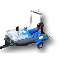
Tech File: Kongsberg’s Compact Survey Vessel
Organization’s performance standards for bathymetric data. The new Dual Ping system provides double the data density along track resolution compared to previous GeoSwath Plus system. As well as significant hardware changes, there has also been a major update to the associated processing and visualization software with the included GS4 package. The GS4 software package offers a number of new features including a feature filter for automatic filtering of vertical structures as well as a new user friendly graphical user interface with an initiative design. The software offers real-time
Open-source Software for Environmental Science Community
Innovative data visualization software developed by Cohort company SEA is available as open-source for the environmental data science community. The software, developed by SEA’s Research and Technical Support (RTS) division, enables users to easily access environmental data from servers over the Internet and view it in a variety of different ways. The highly interactive data viewing enables rapid analysis and understanding of the features of complex, high dimensionality data. RTS has used it for analyzing oceanographic data variability in order to better understand
KATFISH Completes Phase One Sea Trials
Two testing has several operational objectives. The operational depth will be increased to 200 meters, resulting in significantly higher drag forces and a corresponding larger vertical maneuvering envelope. Operators will also be evaluating the first version of Kraken’s new SASView 3D visualization software. At the same time, target detection performance of the first commercially available MINSAS 180 sonar will be evaluated, using known targets of opportunity for detailed resolution and range measurements. Finally, Kraken’s innovative Fault Detection and Fault Response (FDFR)