Lineup Ocean’s SURFREEF Project in Palavas-les-Flots


-
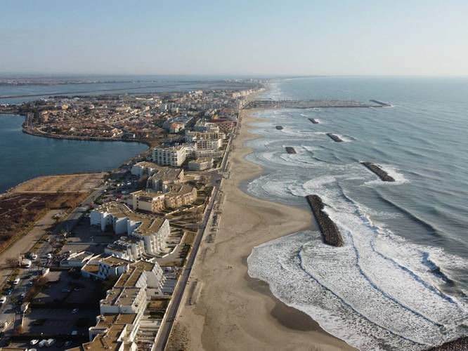 A view on Palavas-les-Flots coastline with waves. © Lineup Ocean
-
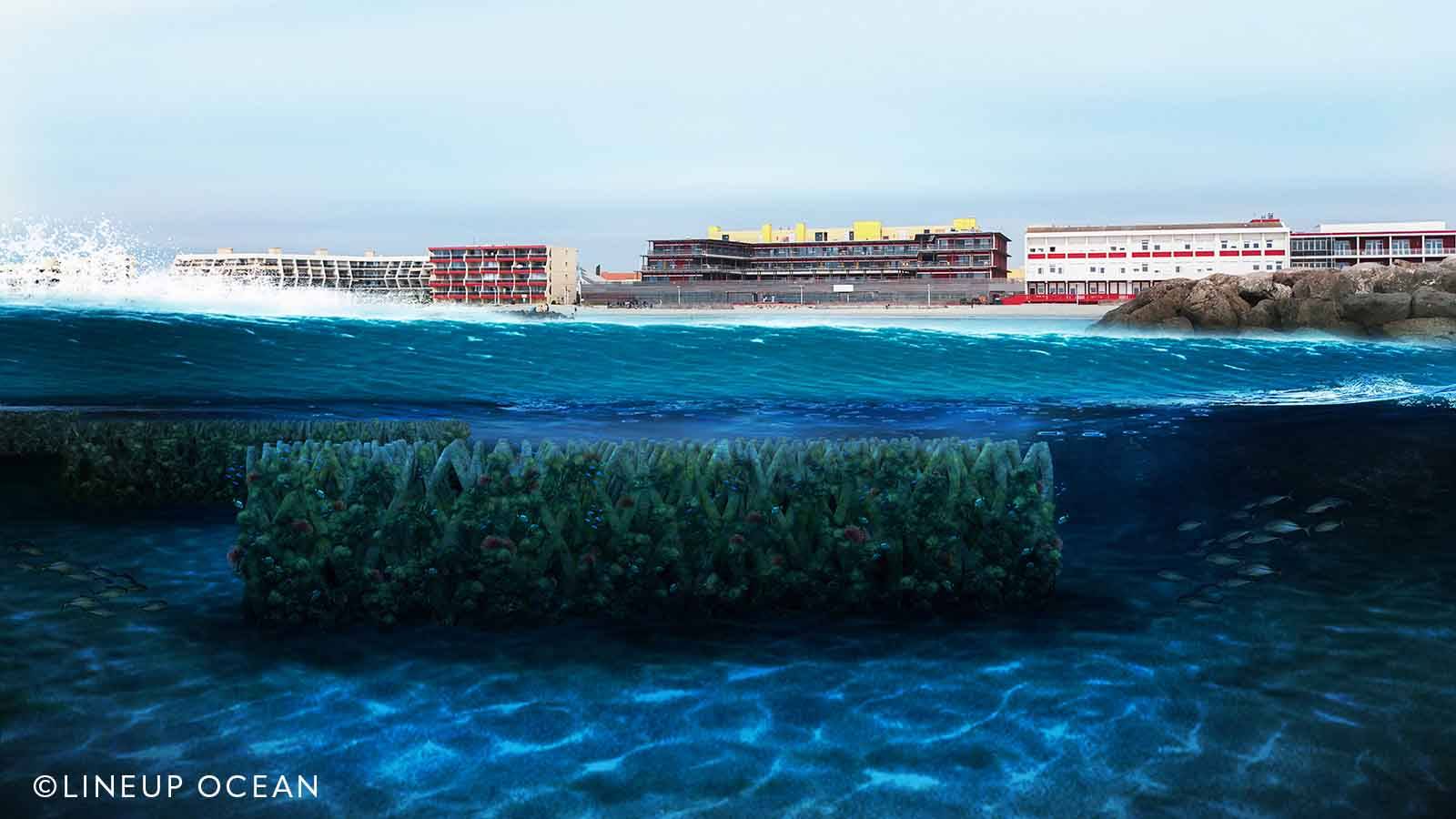
 A simulation view of the UpBlock modules integrated to enhance a beach’s natural resilience. © Lineup Ocean

The Mediterranean coastline faces significant ecological and economic challenges. The Gulf of Lion, which has been studied for erosion and flooding risks for over 15 years, exemplifies these issues. The reduced sediment supply from rivers—including the Rhône—flowing into the gulf has intensified coastal erosion, a problem further exacerbated by climate change.
The increasing frequency and intensity of storms have accelerated beach erosion. Artificial structures built to mitigate this phenomenon, such as rock groynes and breakwaters installed since the 1970s, have often reached their limits. While these structures have helped stabilize sandbanks locally, they degrade over time and prevent the natural regeneration of beaches.
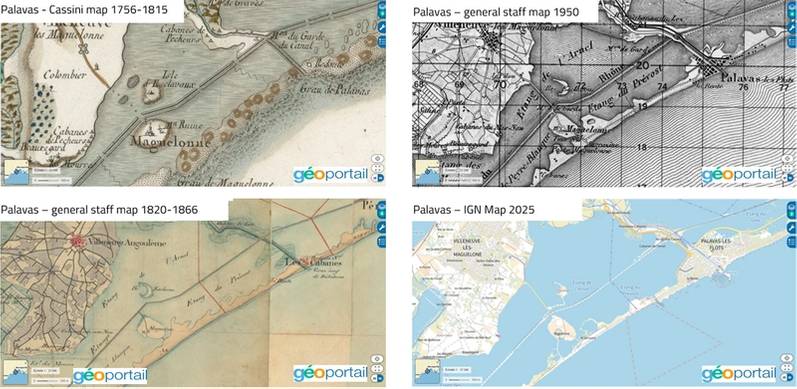 Palavas-les-flots though the age in 4 official maps © Geoportail
In the 2010s, significant beach replenishment projects were undertaken using dredgers. These efforts, costing millions of euros, were intended to provide sand for several years or even decades, according to local stakeholders. However, the effects of storms quickly undermined these projections, reducing their effectiveness to less than five years.
The SURFREEF Project
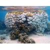
The Lineup Ocean team has extensively studied the processes affecting Mediterranean coasts. With the SURFREEF project, they are testing a new generation of submerged structures designed to limit coastal erosion. Inspired by the natural mechanisms of mangroves, this eco-designed innovation aims to dissipate the energy of destructive waves and promote the regeneration of sandbanks.
The UpBlock modules, 3D-printed from a bio-based material (low-carbon shell mortar), represent a promising French advancement. They are designed to enhance a beach’s natural resilience while supporting local biodiversity.
For YellowScan, the technical challenge of the SURFREEF project is both inspiring and stimulating. The team supported Lineup Ocean by deploying its topo-bathymetric LiDAR system, the Navigator.
Establishing a Baseline
The first phase of the project focused on creating a comprehensive baseline, integrating physical and biological indicators. Topography was a major component of this coastal project. As part of this, the Navigator system was used to model the entire beach, including breakwaters, under calm sea and clear water conditions.
 The YellowScan Navigator mounted on a DJI M600 before the mission. © YellowScan
Bathymetric LiDAR uses green laser pulses. These enable the measurement of the distance from the water’s surface to the seabed. From a flying platform, a laser scanner emits green radiation that passes through the water and is reflected on the bottom of the seabed. The laser scanner collects the reflected radiation of the pulse and calculates the time elapsed between the emission and reception to obtain the distance to both the water surface and seabed. The maximum water depth that can be measured using the Navigator is 2 Secchi depths.
A Carefully Managed Mission
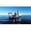
The mission required adherence to numerous parameters. The Navigator system needed a drone capable of carrying a 4 kg payload. The flight scenario chosen was S1, due to the drone’s total weight. The mission utilized a DJI M600, a drone proven for bathymetric LiDAR missions.
Given the urban context and the presence of an air corridor, flight authorizations were obtained, and all legal requirements were followed. Palavas-les-Flots, a popular seaside resort near an airport, also presented logistical challenges. To minimize disruptions, the mapping was conducted at sunrise, with support from the municipal police to secure the area.
To create a comprehensive cartographic baseline, data density was crucial. The plan involved covering the 8-hectare experimental site in less than 20 minutes, at an altitude of 50 meters and a speed of 5 m/s. In practice, the protocol was adapted with three distinct takeoff and landing zones to maintain the maximum allowed distance between the drone and the pilot.
Throughout the operation, the drone pilot, LiDAR operator, and members of the Lineup Ocean and YellowScan teams ensured the smooth execution of the flights. Pedestrians, athletes, and residents were informed about the SURFREEF project and the ongoing mission.
Data Processing
The point clouds generated by the Navigator were processed and classified, then cross-checked with control points (GCP) and, for the terrestrial part, with photogrammetry data. Given the nature of the project and the mapped area, half a day was allocated for data processing.
The topo-bathymetric LiDAR point cloud was processed automatically using YellowScan CloudStation software. The point density underwater was at least 20 points/m². This software was used for classification and filtering to export the seabed as a Digital Terrain Model (DTM).
Comparing LiDAR data with topographic surveys acquired using a GNSS rod (GCP) demonstrated centimeter-level accuracy. This precision is essential for detecting sandbank movements and any changes or displacements of future UpBlock structures or existing breakwaters.
Terrasolid software was thenused to overlay the processed data. Lineup Ocean had conducted photogrammetric modeling in April 2025, while LiDAR acquisition took place in June 2025. The observed differences in the beach profile were attributed to seasonal changes, such as winter storms. Fixed structures and breakwaters served as reference points, showing that the beach profile had evolved between April and June. The LiDAR acquisition revealed a level drop of nearly 20 cm in some areas of the emerged beach, a phenomenon attributed to the establishment of a “summer profile” by the Lineup Ocean team.
Conclusions and Future Prospects
The operation in Palavas-les-Flots, combining a new methodology and a baseline assessment before development, validated the operational capability of the Navigator. This tool effectively fills gaps in bathymetric data while ensuring the continuity of topographic data with centimeter precision.
The flight protocol, approved by authorities, will serve as a reference for future operations. The next data acquisitions will occur during the installation of a demonstrator segment of UpBlock modules and after the first storm, to measure sandbank movements on the site. YellowScan will participate in these operations as a technical partner.
YellowScan thanks the Lineup Ocean team for their trust and openness to new technologies, as well as the municipality of Palavas-les-Flots and the Directorate General of Civil Aviation for their support.
About the author
With a background in hydrobiology and habitat surveying, Florian Caraveo has built a cross-functional career in marketing and business, always driven by a commitment to ecosystem preservation. Currently, he specializes in LiDAR technologies for drones at YellowScan, where he bridges innovation with environmental and societal impact. By advancing projects that protect communities and support research, he believes in sustainable solutions—proving that technology can serve both progress and nature.
 © Florian Caraveo/YellowScan