Ocean-Bottom Seismometers Play Crucial Role in Offshore Sensing
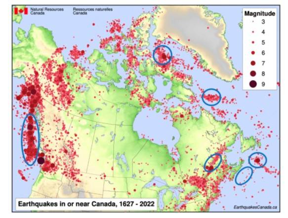
Blue ellipses show where NFSI OBS have been deployed offshore Canada to date. Image from NFSI.
Much of central Canada lies on very old, stable bedrock with little seismic activity. In contrast, the county’s coastlines face far greater seismic risk, particularly (but not limited to) the west coast. Of greatest concern is a major subduction zone off Vancouver Island, where tectonic plates pushing together suggest a large earthquake is due.
Canada is all too familiar with the impact of offshore earthquakes. The magnitude 7.2 Grand Banks earthquake of 1929 triggered one of the most destructive tsunamis ever recorded in the country, devastating coastal communities in Newfoundland and Cape Breton. As a result, Canada’s National Facility for Seismological Investigations (NFSI) was set up in 2021 to investigate, characterize and predict this risk, in Canada and overseas.
Based at Dalhousie University and supported by a partnership of 10 Canadian universities, NFSI was funded through a major Canadian Foundation for Innovation investment with approximately USD$10.77 (C$15 million) allocated for equipment and infrastructure.
Core to this is a national pool of more than 120 broadband ocean-bottom seismometers (OBS). Since operations launched in 2023, around 100 of these have been deployed annually in locations ranging from the Arctic to New Zealand. By placing seismometers directly on the seafloor, researchers can detect much smaller offshore earthquakes and determine their locations far more accurately than is possible using land-based sensors alone.
But positioning them and, crucially, recovering them to download their data, then getting them ready for the next deployment, isn’t simple, especially when locations range from ice-covered Arctic waters to 4,700 m deep abyssal plain. And because the NSFI team relies on diverse “vessels of opportunity," from small fishing boats to ice-rated trawlers and large coastguard ships, and operates with a very small field staff, their choice of underwater positioning also has to be flexible.
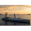
 Deployment in January in New Zealand. Photo from NFSI.
The solution
The ideal scenario, to enable accurate positioning and efficient recovery, is to use a precise Ultra-Short BaseLine (USBL) positioning system. NFSI acquired the Sonardyne Ranger 2 Gyro USBL system for this reason.
Gyro USBL is designed as a pre‑calibrated, all‑in‑one unit, with the acoustic transceiver and attitude and heading reference system (AHRS) factory‑aligned in one housing. This compact configuration removes alignment/lever‑arm errors, reduces setup time and means it can be easily moved from vessel to vessel, with over-the-side pole mounting, for example, without the need for time-consuming calibration routines.
By compensating for vessel motion while providing direction to an instrument as well as distance, Gyro USBL enables quick and precise instrument location on the seafloor and real-time tracking during recovery, allowing vessels to intercept instruments as they surface. This accuracy reduces ship time, lowers operational risk, and ensures reliable data recovery even in Canada’s most hazardous offshore environments.
Due to the range of water depths in which they deploy OBS, NFSI chose an LMF (low medium frequency) version of Ranger 2 Gyro USBL, enabling longer tracking ranges, up to 11,000 m slant range, compared with our standard MF (medium frequency) 7,000 m range.
But when it comes to having to work from a small vessel, or where mounting the Ranger 2 Gyro USBL transceiver isn’t practical, seafloor instruments are positioned by surface triangulation using our directional Modem 6 Dunker. This method uses ranges to the OBS from three of four surface positions (by moving their vessel to different locations), and pressure data from the OBS communicated acoustically, to calculate the OBS’ position, including depth, on the seafloor. To cover all scenarios, NFSI chose a Modem 6 Mini Dunker directional variant, giving it the extra range (to 3,000 m) and more targeted signal strength, helping overcome any ship noise, thanks to its focused acoustics.
 A Ranger 2 Gyro USBL head on a over-the-side pole mounting.
The results
- Monitoring geohazards:
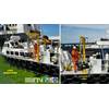
- NFSI’s Ranger 2 Gyro USBL system was heavily used on the PACSAFE and Endeavour projects off the west coast of British Columbia.
- PACSAFE is a multiyear mission focusing on the northern part of the Cascadia Subduction Zone. Its aim is to collect data on offshore seismic activity and assess earthquake and tsunami hazards in this high-risk area.
- Endeavour was a time-sensitive collaboration aimed at “catching” a volcanic eruption, which scientists expect to erupt within the next year or so. This is focused on the Endeavour Ridge, part of the Juan de Fuca Ridge system, which lies off the west coast of Vancouver Island.
- For these projects, NFSI was able to use a large Canadian Coast Guard ship equipped with a dedicated over-the-side pole deployment for the Gyro USBL transceiver.
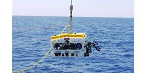
 Operations during Pacific Coast Seismic Assessment for Faults and Earthquakes (PACSAFE) project. Photo from Geological Survey of Canada.
- Endeavour:
- The Endeavour mission, a collaborative effort between NFSI, Ocean Networks Canada (ONC) and the University of Washington, was particularly demanding.
- “Ranger 2 played a central role in deploying and positioning an array of 20 ocean-bottom instruments designed to capture this event. Compared with traditional triangulation, the Gyro USBL delivered significantly higher positional accuracy and statistical confidence, ensuring the position of each instrument in a bathymetrically complex environment was measured with high precision," said Dr. Graeme Cairns, NFSI Manager, Earth & Environmental Sciences, Dalhousie University.
- Even in the presence of ship noise and pole-induced vibration (factors that would stop normal USBLs from operating), the system maintained reliable communication at offsets of approximately 1.5 to 2 km, in water depths of up to 2,500 m. This performance allowed the team to individually verify the status and location of every node in a complex and hazardous seismic environment.
- Building on the Laurentian Fan:
- These operations built on NFSI’s earliest deep-water experience with Ranger 2 at the Laurentian Fan in August 2022. At this historic site, best known as the source of the devastating 1929 tsunami, the system successfully communicated with instruments at depths of 4,700 m, the deepest deployment ever undertaken by NFSI. That mission demonstrated their Ranger 2 system’s ability to deliver dependable directional ranging and communication at extreme depths.
- Deploying the Dunker:
- When it’s not possible to mount the Ranger 2 Gyro USBL, our Modem 6 Mini Dunker comes into play. Its portability and versatility, and directional focus, allow NFSI to operate effectively from a wide range of vessels, including small fishing boats.
- The LOBEX project (2023-2024) operated in the St. Lawrence Seaway, a waterway connecting the Great Lakes to the Atlantic Ocean through Ontario, Quebec, and New York. Deployed with local fishermen in day-trip outings, the OBSs were used to monitor both seismic activity and endangered baleen whale behaviour in this strategically important and ecologically rich corridor.
- The Modem 6 Dunker’s ability to perform surface triangulation—moving the vessel between a few points over roughly an hour—enabled rapid, flexible and cost-effective operations from small boats in a constrained environment.
- A back up in Baffin Bay:
- Beyond coastal missions, the Modem 6 Dunker has proven critical for high-stakes, high-budget operations from large boats in remote areas. In Baffin Bay, for instance, where Arctic ship time can cost millions, the dunker functions as a primary or backup communication system.
 Operations in Baffin Bay and Labrador. Photos from NFSI.
A shift to recovery
Following an intensely busy two years, the NFSI team is shifting its focus from rapid data acquisition to strategic international expansion and technological development.
The primary deployment of 2026 will be the TRACE project in May—a broad European collaboration involving French, Italian and Croatian institutes. This “amphibious survey” will deploy 20 instruments across the Adriatic Sea, integrating marine and land-based seismic monitoring with both nodal and distributed acoustic sensing (DAS) cable systems in a new international context.
For the remainder of 2026, NFSI will focus on instrument recoveries and turnarounds rather than new deployments.
- In July, 21 units will be recovered from the Explorer Plate and redeployed offshore Haida Gwai.
- In back-to-back cruises, this will be followed immediately by recovery of 18 units from the Endeavour Ridge in early August, with redeployment of five instruments.
- In September/October, 22 instruments are scheduled for recovery from the Labrador Sea.
Two major international expeditions are under discussion for 2027 or 2028—a large-scale active-source survey on the East Pacific Rise and a significant research campaign off the coast of Chile.
Efforts are also underway to improve the speed of data processing and interpretation, closing the gap between acquisition and analysis.
Conclusion
From ice-covered Arctic waters to abyssal plains, deploying and recovering ocean-bottom seismometers is essential for understanding crustal structure and assessing geohazards. But it only works when teams can pinpoint instruments on the seabed and communicate with them reliably for recovery.
By combining the high-precision Ranger 2 Gyro USBL with the portable Modem 6 Dunker for scenarios where fixed mounting isn’t practical, NFSI builds in operational flexibility.
It can operate from vessels of opportunity while reducing ship time, lowering risk and ensuring dependable data return in some of the world’s most demanding offshore environments.