Survey Sequence Important to Predicting Underwater Landslides
© alexyz3d / Adobe Stock
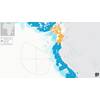
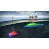
Submarine landslides can hamper the productivity of offshore installations, but researchers at Texas A&M may now be able to accurately predict the occurrence of marine landslides using underwater site characterization data.
Although data from personnel with different expertise are needed to tell the story of the land below the sea, the order in which they perform their tasks toward site characterization is important, says Zenon Medina-Cetina, associate professor in the Department of Civil & Environmental Engineering. This sequence, if violated due to budgetary or time constraints, could lead to uncertainty in the prediction of landslides.
“It is very important to start with the geophysicist and then bring in the geologist and then have the geomatics group working with the geotechnical engineers,” said Medina-Cetina. “As an analogy, imagine that I need to train a baby to walk while teaching it how to run. This is going to be much harder, right? A systematic sequence on the use of evidence ensures that the landslide models are better calibrated by learning from the data as they are being produced.”
The researchers noted that companies funding offshore projects typically lose money when they are not confident that the designs of the subsea civil infrastructures can withstand geohazards. Thus, Medina-Cetina and his team’s model calibration methodology uses a probabilistic approach called Bayesian statistics to maximize the information produced in site investigation data. This methodology, they demonstrated, increases the accuracy and confidence of the landslide model when it makes predictions.
They introduce a systematic approach to produce prior probability distributions of the model parameters based on an actual integrated marine site investigation including geological, geophysical, and geomatics data, to then compare it with a posterior probability distribution of the same model parameters, but estimated after collecting in situ soil samples and testing them in the laboratory to produce the corresponding soil strength properties.
This comparison allows for consideration of the influence of the number of in situ samples, the influence of a landslide factor of safety and the influence of the soil heterogeneity into the likelihood of the occurrence of a marine landslide. The model parameters that are considered for calibration include the initial state of the submerged and saturated soil unit weight, the thickness of the soils’ unit layers, the pseudo-static seismic coefficient and the slope angle, while the soil undrained shear strength is considered as the reference parameter to conduct the calibration.
The researchers have published their work in the journal Landslides.