Teledyne Optech to Bring Bathymetry Solutions to OI
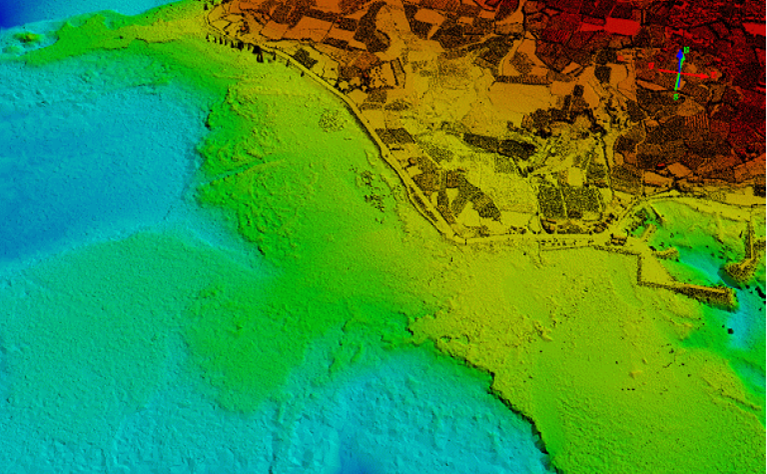
Seamless topo/bathy data from Optech CZMIL Nova’s recent survey of Korea’s coast (image courtesy KHOA)
Teledyne Optech announced that it will be taking its most powerful and flexible surveying tools to London, England for Oceanology International 2016 on March 15-17. Members of Teledyne Optech’s science and engineering team will be at stand F100 to explain the full capabilities of these tools and show how they can help governments, businesses and researchers to monitor the coastal environment quickly and accurately.
The advanced airborne lidar bathymeter, the Optech CZMIL Nova, is now available for rental, putting it within the reach of many medium-sized organizations and government groups. Teledyne Optech staff will explain how the CZMIL Nova collects lidar, hyperspectral and photogrammetric data simultaneously, and how its advanced Optech HydroFusion workflow automatically generates a wide range of deliverables including bathymetric, water/seafloor reflectance and benthic classification maps. Interested parties can also learn about renting the system with the support of Teledyne Optech’s highly trained operators through the CZMIL Project Program, or hear about CZMIL Nova’s recent successful projects, including Gatun Lake for the Panama Canal Authority, portions of the Korean coast for the Korean Hydrographic and Oceanographic Administration (KHOA), and a demonstration in the turbid waters of Tampa Bay, Fla.
For efficient topo/bathy surveying and advanced target classification, Teledyne Optech will also present the capabilities of the Optech Titan, the first commercial multispectral airborne lidar. Equipped with a water-penetrating green channel and two infrared channels, the Titan maps both land and shallow coastal waters efficiently in the same flight. In addition, the Titan’s three separate wavelengths enable automated target classification, helping surveyors differentiate trees, soil, grass and more.
Harbor managers and port authorities looking for a low-cost survey solution will be interested in the integrated lidar/sonar solution developed with our sister company Teledyne RESON. By combining a long-range Optech ILRIS terrestrial lidar scanner with a RESON SeaBat multibeam echosounder on a light watercraft, this solution lets surveyors map above and below the waterline simultaneously and view the data immediately in Teledyne PDS software.