Ocean Science and Research
Short Introduction to Ocean Science and Research: Marine Geology, Geophysics and Biology
Marine Geology and Geophysics
As a significant part of the ocean science and research, marine geology and geophysics have started with the collection of the first samples of sediment from the seabed, approximately 150 years ago. These sciences study the activity, structure and other phenomena related to the oceanic platforms, which are, in fact, the outer blanket of the Earth (the oceanic lithosphere) – a rigid layer with a thickness of about 100 km. The oceanic platform is very different from the continental one. It is much thinner and has been created within the past 200 million years.
In 1960, Professor Harry Hess of Princeton University in New Jersey, involved in ocean science and research, said that the oceanic platform is in constant expansion due to underwater mountain chains. He calculated that a new oceanic crust is forming, which grows with a few centimeters a year, which was fast enough so that the whole oceanic platform to form within the last 200 million years. Around the edges there are some oceanic deep abysses. The deepest of these is the Mariana Trench, which descends to 11,033 m and is located near the Pacific island of Guam.
By examining the age of the underwater rocks located near the mountain chain in the middle of Atlantic Ocean, specialists in ocean science and research have discovered that the oceanic platform is expanding at a speed of 2 cm per year, on each side of the mountain chain, which means that the Atlantic Ocean widens at a speed of 4 cm per year.
There are mountain chains in the central area of the ocean, which are interspersed with some cracks called fracture zones. They can stretch up to 60,000 km at the bottom of all oceans. The chain extends from the Central Atlantic Norwegian Sea through the volcanic islands of Iceland and the Azores to the South Atlantic, where it is quasidistant of African and South American coast. The chain continues in the Indian Ocean with an arm that reaches the Red Sea, and then passes between Australia and Antarctica and into the eastern Pacific. These mountain ranges have an important role in ocean science and research, as they affect the behavior of the tectonic plates.
On the ocean floor, along the ridges axes, basalt climbs and solidifies, causing the sliding of plates, thus the deformation of continents. Because all the oceans communicate with each other, the level of their surface is the same everywhere. It is level 0, the one where waves and tides wash the shores. The average altitude of this level is unstable, varying over long durations. For example, 30,000 years ago, level 0 was about 90 m lower than today.
This occurs due to changes of climate. When the weather is cold for a long time, glaciers stretch, retain more water and the liquid water level decreases. Today, this level seems to increase and reclaim parts of the banks, because winters are warmer, last for shorter time, and glaciers lose more water. On land, the erosion seems to slow down slightly: the ascension of zero level corresponds, indeed, to a loss of altitude of land and thus, to the digging power of flowing water. The structure and topography of the ocean basins is measured and analyzed with the aid of satellites, for a more detailed study of the ocean floor. Satellites measure the level of the surface to estimate how close the ocean bottom is. Sonar can also help to tell the relative depth of the ocean. Specialists in ocean science and research have developed tools that can make this process slightly easier. The Robotuna undersea vehicle, for instance, was one of the first underwater robots created to the purpose of mapping the ocean floor. However, even with the latest techniques, we would need 125 years to map the ocean bottom.
Marine Biology
Marine biology is an important object of study incorporated in the ocean science and research. Its object is all forms of life in the littoral and abyssal areas of the ocean. Coast areas are situated, usually, on the continental marine platforms; life here is influenced, to a large extent, by environmental conditions and water dynamics. Submarine topography characterized by different biotypes ensures the development of flora and fauna closely related to its configuration. Life in the pelagic zone develops at the depth where light penetrates, down to 400-500 m. The flora and fauna which inhabit central areas on the ocean lives in a more homogeneous aquatic environment, unlike the coastal environment that is more heterogeneous.
Finally, life in the abyssal zone covers the entire mass of ocean water, where no light penetrates, where the water is dark and its motion has a relative stability. The temperature keeps around 2 degrees Celsius, and the salinity, depending on the depth, varies between 32% and 34%. Due to permanent darkness, the plants cannot survive in this environment, and the animals subsequently lost their sight, developing tactile organs instead. These animals are generally colorless, red, black or white. The way these animals feed is very different; some of them are content with eating cadavers, others consume the excrements of the livestock, and others feed with live animals.
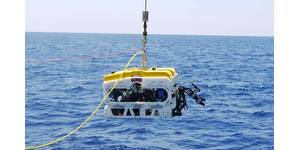
In order to study the marine creatures living in the planetary ocean, as well as the physical-chemical phenomena unfolding in water, researchers use various types of submersible vehicles, equipped with sensors to record, but each of them has its limitations. Vehicles without a motor, the so-called "sliders" can remain in water for months and are very useful for studying the physical properties of the environment, but are slow and their sensors are not sensitive enough to record details of life forms. Motor vehicles, underwater robots, are fast and equipped with sophisticated sensors, but they consume more energy, thus limiting the time that the robotic vehicle can spend in the ocean; usually after a shift of "work", the robot has to be returned to shore or on the boat for refueling. Some robots can recharge with solar energy, but their time undersea is even more limited.
As a significant part of the ocean science and research, marine geology and geophysics have started with the collection of the first samples of sediment from the seabed, approximately 150 years ago. These sciences study the activity, structure and other phenomena related to the oceanic platforms, which are, in fact, the outer blanket of the Earth (the oceanic lithosphere) – a rigid layer with a thickness of about 100 km. The oceanic platform is very different from the continental one. It is much thinner and has been created within the past 200 million years.
In 1960, Professor Harry Hess of Princeton University in New Jersey, involved in ocean science and research, said that the oceanic platform is in constant expansion due to underwater mountain chains. He calculated that a new oceanic crust is forming, which grows with a few centimeters a year, which was fast enough so that the whole oceanic platform to form within the last 200 million years. Around the edges there are some oceanic deep abysses. The deepest of these is the Mariana Trench, which descends to 11,033 m and is located near the Pacific island of Guam.
By examining the age of the underwater rocks located near the mountain chain in the middle of Atlantic Ocean, specialists in ocean science and research have discovered that the oceanic platform is expanding at a speed of 2 cm per year, on each side of the mountain chain, which means that the Atlantic Ocean widens at a speed of 4 cm per year.
There are mountain chains in the central area of the ocean, which are interspersed with some cracks called fracture zones. They can stretch up to 60,000 km at the bottom of all oceans. The chain extends from the Central Atlantic Norwegian Sea through the volcanic islands of Iceland and the Azores to the South Atlantic, where it is quasidistant of African and South American coast. The chain continues in the Indian Ocean with an arm that reaches the Red Sea, and then passes between Australia and Antarctica and into the eastern Pacific. These mountain ranges have an important role in ocean science and research, as they affect the behavior of the tectonic plates.
On the ocean floor, along the ridges axes, basalt climbs and solidifies, causing the sliding of plates, thus the deformation of continents. Because all the oceans communicate with each other, the level of their surface is the same everywhere. It is level 0, the one where waves and tides wash the shores. The average altitude of this level is unstable, varying over long durations. For example, 30,000 years ago, level 0 was about 90 m lower than today.
This occurs due to changes of climate. When the weather is cold for a long time, glaciers stretch, retain more water and the liquid water level decreases. Today, this level seems to increase and reclaim parts of the banks, because winters are warmer, last for shorter time, and glaciers lose more water. On land, the erosion seems to slow down slightly: the ascension of zero level corresponds, indeed, to a loss of altitude of land and thus, to the digging power of flowing water. The structure and topography of the ocean basins is measured and analyzed with the aid of satellites, for a more detailed study of the ocean floor. Satellites measure the level of the surface to estimate how close the ocean bottom is. Sonar can also help to tell the relative depth of the ocean. Specialists in ocean science and research have developed tools that can make this process slightly easier. The Robotuna undersea vehicle, for instance, was one of the first underwater robots created to the purpose of mapping the ocean floor. However, even with the latest techniques, we would need 125 years to map the ocean bottom.
Marine Biology
Marine biology is an important object of study incorporated in the ocean science and research. Its object is all forms of life in the littoral and abyssal areas of the ocean. Coast areas are situated, usually, on the continental marine platforms; life here is influenced, to a large extent, by environmental conditions and water dynamics. Submarine topography characterized by different biotypes ensures the development of flora and fauna closely related to its configuration. Life in the pelagic zone develops at the depth where light penetrates, down to 400-500 m. The flora and fauna which inhabit central areas on the ocean lives in a more homogeneous aquatic environment, unlike the coastal environment that is more heterogeneous.
Finally, life in the abyssal zone covers the entire mass of ocean water, where no light penetrates, where the water is dark and its motion has a relative stability. The temperature keeps around 2 degrees Celsius, and the salinity, depending on the depth, varies between 32% and 34%. Due to permanent darkness, the plants cannot survive in this environment, and the animals subsequently lost their sight, developing tactile organs instead. These animals are generally colorless, red, black or white. The way these animals feed is very different; some of them are content with eating cadavers, others consume the excrements of the livestock, and others feed with live animals.
In order to study the marine creatures living in the planetary ocean, as well as the physical-chemical phenomena unfolding in water, researchers use various types of submersible vehicles, equipped with sensors to record, but each of them has its limitations. Vehicles without a motor, the so-called "sliders" can remain in water for months and are very useful for studying the physical properties of the environment, but are slow and their sensors are not sensitive enough to record details of life forms. Motor vehicles, underwater robots, are fast and equipped with sophisticated sensors, but they consume more energy, thus limiting the time that the robotic vehicle can spend in the ocean; usually after a shift of "work", the robot has to be returned to shore or on the boat for refueling. Some robots can recharge with solar energy, but their time undersea is even more limited.