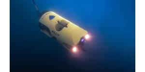
Blueye: Making An ROV Autonomous
real-time data transmission directly to the surface, providing operators with live video and sensor data essential for precise and safe underwater maneuvering. In addition, control signals are sent down to the ROV through the same tether, allowing the operator to continuously adjust direction, speed and camera angle, ensuring full control of the drone at all times.A tethered system also provides a simple setup, eliminating the need for complex wireless solutions or external base stations. The system is mobile and flexible—it can be used almost everywhere, whether from shore, a boat, or a dock.The
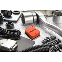
Xsens Announces New OEM Inertial Measurement Unit
is 15μg.Weighing 35.2g, the Xsens Avior is enclosed in a robust aluminum housing and has a rating of IP51 and an operating temperature range of -40°C to 85°C. The sensor’s small size, light weight, high performance and robust construction provide outstanding value in applications such as:Camera/payload stabilization, including SOTM (SATCOM-on-the-Move) devicesMarine equipment – remotely-operated vehicles (ROVs), autonomous underwater vehicles (AUVs), sensor buoysMobile robots and autonomous mobile robots (AMRs)Drones and 3D mapping and surveying toolsHumanoid robotsThe new sensor
Teledyne Marine's 2025 Photo and Data Contest Is Now Open
Showcasing moments of resilience, technical challenges and extreme conditions.Moment of Zen Award: Capturing you or your team in picturesque settings utilising Teledyne Marine equipment.Underwater Award: Recognizing the best underwater images featuring Teledyne Marine products or captured using Bowtech cameras.Winners of the four jury-selected categories will receive a KODAK PIXPRO WPZ2 Rugged Waterproof Digital Camera.How to Enter:Upload your best photos or data samples to the contest page before September 30, 2025.Promote your submission by sharing it on social media—tagging @TeledyneMarine on

The Ocean Cleanup: Call for Sailors to Take Part in Plastic Research
expedition to help map plastic in The Great Pacific Garbage Patch (GPGP).This summer, the Dutch non-profit is looking to track the patch, the world’s largest accumulation of floating plastic, using AI technology so they can clean it more efficiently in the future.Sailors willing to fit the AI cameras and use GPS trackers on their leisure trips or during regattas can advance understanding of the patch’s composition to help future cleanup efforts.The organization, whose mission is to rid the world’s oceans of plastic, has removed more than one million pounds of trash from the GPGP
NOC Expedition Marks 40 Years of Abyssal Science Project
, Whittard Canyon, for a full year.Scientists hope the sounds captured could provide insights into everything from elusive whales and dolphins to submarine canyon landslides at Whittard Canyon and also unlock the mysteries of the soundscape of a site like the PAP-SO, nearly 5 km down.A time-lapse camera system, Bathysnap, that has been sitting on the seafloor taking images every few hours for the past year will also be recovered and replaced, with scientists excited to see what creatures it has caught a glimpse of.A newly acquired specialized camera system able to take images of single cell organisms
Silicon Sensing, Kongsberg Discovery Join Forces to Develop Gyro Technology
together to co-develop next-generation inertial technology.Gyro sensors measure changes in rotation angle over time, enabling detection of direction, angle, and vibration. They are used in smartphones, game consoles, car navigation systems, industrial equipment, and devices requiring vibration detection, camera shake correction, and attitude control.This agreement will merge the engineering skills of both companies to speed the evolution of products within each company. Kongsberg will use developments to enhance their next generation of high-performance systems—including Attitude and Heading Reference
Ocean Robots Explore the Role of ‘Marine Snow’ in Carbon Storage
underwater vehicles, the project seeks to understand how carbon-rich particles sink through the water column and how physical ocean processes, such as deep convection currents, might enhance carbon storage in this remote and understudied region.An innovation in the project is the FluxCAM, a marine snow camera system designed to measure the sinking speeds of different-sized particles to reduce uncertainties in how much carbon the ocean absorbs from the atmosphere.Two FluxCAMs were installed on a deep-sea mooring in the Labrador Sea, between Newfoundland and Greenland, last year, along with a specially
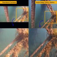
Voyis Launches Deep Vision Optics for Underwater Imaging
in underwater optical sensor technology, announced the launch of the Deep Vision Optics, an optical system designed to enhance image clarity and sharpness in subsea environments. This solution is being released for the Voyis’ Discovery Vision Systems and the Observer Imaging Systems.Underwater cameras face a significant challenge in maintaining focus across their entire field of view and working range due to the water medium. Traditional dome viewports affect image formation and focus, leading to poor corner focus that limit the usability of the camera’s field of view. They also reduce
Teledyne Marine to Participate in the SeaSEC Challenge 2025
deploy its SeaBat T51 both on the survey vessel and on an USV, alongside the Gavia AUV with the SeaBat T20.The team will leverage Teledyne Geospatial’s lidar platform for additional support, ensuring comprehensive coverage and precise mapping. Teledyne Marine will also deploy a FLIR infrared camera positioned in the harbour to provide continuous visual monitoring of the offshore challenge zones up to 8 nautical miles out to sea.SeaSEC Challenge 2025 runs from May 12-23, 2025, at SeaSEC’s maritime testing grounds off the coast of Scheveningen, Netherlands. SeaSEC was founded in December