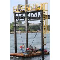
MRECo Develops Two Marine Energy Test Sites in Massachusetts
The Marine Renewable Energy Collaborative of New England (MRECo) is developing and improving two ocean testing sites in Massachusetts: the Bourne Tidal Test Site (BTTS) in the Cape Cod Canal and the Cuttyhunk Test Range (CTR) off Cuttyhunk Island.Together, these sites give innovators a safe, affordable, and permitted way to deploy new ocean technologies in the water, bridging the gap between lab experiments and real-world use.The Bourne Tidal Test Site, located in the Cape Cod Canal, is a platform built specifically for testing tidal energy devices and marine sensors in fast-moving water. The site
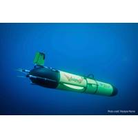
Underwater Autonomous Glider Departs to Circumnavigate the Globe
Australia, then on to Wellington, New Zealand. It will then navigate the Antarctic Circumpolar Current — the most powerful current on Earth — taking it on its longest leg to the Falkland Islands. From here there will be possible stops in Brazil and the Caribbean before heading back to Cape Cod in the U.S.Transmitting information via satellite when it surfaces every 8-12 hours, Redwing will share vital data on ocean temperature, salinity, currents, and ocean health via the National Oceanic and Atmospheric Administration’s (NOAA) global monitoring system. This will ensure that

Massachusetts Clean Energy Center Awards $11.3 Million to Advance Ocean Technology Innovation
for seven organizations through its new Ocean Innovation Network. The program will further position Massachusetts as a leader in ocean technology, accelerating the development of new solutions while fostering connections among marine science and technology businesses, particularly on the South Coast, Cape Cod, and the North Shore.The announcement took place at New Bedford Research and Robotics during the Southeast stop of MassCEC’s Climatetech Corridor Roadshow, following morning sessions at UMass Dartmouth. Dr. Emily Reichert, CEO of MassCEC, was joined by New Bedford Mayor Jon Mitchell to highlight
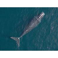
New England Aquarium Researchers Use Drone Technology to Monitor Climate Change Impacts on Whales
of fishing gear entanglements and vessel strikes in areas without existing protection measures. The right whale population is estimated at only about 370 individuals.Alongside colleagues from Woods Hole Oceanographic Institution, Dr. Durban has been deploying drones for right whale photogrammetry in Cape Cod Bay over the last decade. He is now collaborating with the Anderson Cabot Center’s aerial survey team, led by Research Scientist Orla O’Brien, to broaden this effort by outfitting the team’s research plane with special cameras. The technology will allow scientists to collect
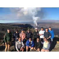
MMA Students Complete Real-World Training in Hawaii
Cadets from Massachusetts Maritime Academy (MMA) have completed a Geological Oceanography field course in Hawaii, an innovative experiential learning course 8,000 kilometers from their Cape Cod campus.Eleven students, majoring in Marine Science, Safety, and Environmental Protections (MSSEP), participated in a rigorous, hands-on educational journey to Hawaii from January 3 to January 17, 2025.Shortly after arrival they were taken to Kilauea caldera to observe a 200-foot-high lava fountaining eruption. They then went on day-long hikes through volcanic terrane.In subsequent days, students snorkeled in
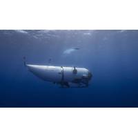
Titanic Sub Pieces Found on Ocean Floor; No Survivors
96 hours when it entered the water on Sunday around 8 a.m. (1200 GMT), meaning that the occupants likely would have run out of oxygen by Thursday morning.The Titanic, which sank in 1912 on its maiden voyage after hitting an iceberg, killing more than 1,500 people, lies about 900 miles (1,450 km) east of Cape Cod, Massachusetts, and 400 miles (640 km) south of St. John's, Newfoundland.The expedition to the wreck, which OceanGate has been operating since 2021, cost $250,000 per person, according to OceanGate's website.Questions about Titan's safety were raised in 2018 during a symposium of submersible
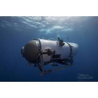
Titanic Sub Search: Debris Field Found, Oxygen Feared to Have Run Out
from the Titan.U.S. Coast Guard rear admiral John Mauger told broadcaster NBC earlier on Thursday that the search would continue throughout the day.The Titanic, which sank in 1912 on its maiden voyage after hitting an iceberg, killing more than 1,500 people, lies about 900 miles (1,450 km) east of Cape Cod, Massachusetts, and 400 miles (640 km) south of St. John's, Newfoundland.The Titan's deep-sea excursion to the shipwreck capped a tourist adventure for which OceanGate charges $250,000 per person.The passengers included British billionaire and adventurer Hamish Harding, 58, and Pakistani-born
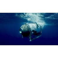
Search for Missing Titanic Sub Focuses on Area Where Sounds Detected
on a range of factors, including whether the submersible remains intact and still has power.The wreck of the British ocean liner, which sank when it hit an iceberg on its maiden voyage in 1912, lies on the seabed at a depth of about 12,500 feet (3,810 meters). It is about 900 miles (1,450 km) east of Cape Cod, Massachusetts, and 400 miles south of St. John's, Newfoundland.Those aboard the submersible, the highlight of a tourist adventure that costs $250,000 per person, included British billionaire and adventurer Hamish Harding, 58, and Pakistani-born businessman Shahzada Dawood, 48, with his 19-year-old
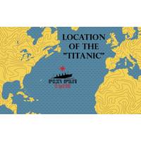
Missing Titanic Submersible Update: Searchers Detect Subsea Sounds
of open sea larger than the state of Connecticut.The wreck of the Titanic, a British ocean liner that struck an iceberg during its maiden voyage on the night of April 14, 1912, and sank the next morning, lies some 12,500 feet (3,810 meters) beneath the surface - about 900 miles (1,450 km) east of Cape Cod, Massachusetts, and 400 miles (644 km) south of St. John's, Newfoundland.As of Tuesday, aircraft and ships from the U.S. Coast Guard, U.S. Navy and Canadian armed forces had combed more than 7,600 square miles of the North Atlantic, U.S. Coast Guard Captain Jamie Frederick told reporters at