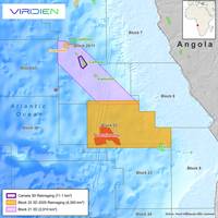
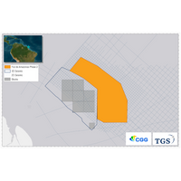
Viridien Set for Seismic Reimaging of Block 22 Offshore Angola
the country’s upcoming licensing round.The 4,300 sq km high-end data set will bring valuable insight into underexplored structures along the Atlantic Hinge zone, following the same trend as the proven Cameia and Golfinho fields.Fast-track results are scheduled for delivery in Q1 2026 and final products in Q3/Q4 2026.Viridien will reimage the block 22 data set with its latest proven proprietary technologies, including time-lag FWI, Q-FWI, Q-Kirchhoff and advanced deghosting and demultiple.This data will complement its 2,900 sq km of data over nearby block 20/11, giving operators access to a
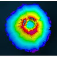
Viridien, TGS Wrap Up OBN Survey in Gulf of America
set will be imaged using Viridien’s elastic full-waveform inversion (E-FWI) to improve subsalt structural clarity and support further exploration in central Keathley Canyon. Early-out products will be available at the end of October in time for the offshore lease sale scheduled in December. Final products will be delivered in early the first quarter of 2027. “Together with TGS, we are acquiring high-quality OBN data and applying our most advanced imaging to give operators the clearest view of these promising yet complex subsalt plays. This collaboration continues to raise the bar for
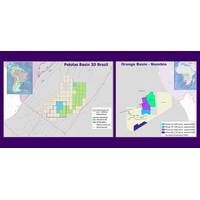
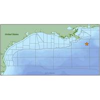
Shearwater Kicks Off Pelotas Basin 3D Survey Off Brazil
.The initial phase of the Pelotas Basin 3D will be 3,800 sq.km, extending to 7,000 sq.km with a planned extension.The joint-venture partners have prior to this successfully acquired over 12,500 sq.km in the highly prolific Orange Basin with significant industry support from multiple clients.The final products of the four adjacent projects in the Orange Basin will be delivered upon completion of processing throughout 2024."It’s an exciting time as we build a fit for purpose organization to support Shearwater’s organic entry into multi-client. Together with complementary partnerships
CGG Releases Gulf of Mexico Carbon Storage Study
French seismic data specialist CGG has announced the delivery of the eastern phase of its GeoVerse Carbon Storage Gulf of Mexico Study and the start of the westward extension of the study. Both phases of the project, supported by industry funding, are available for license now with final products for the westward expansion phase available in Q1, 2024, CGG said.According to CGG, these studies provide an accurate, unique, and independent map-based assessment of carbon storage opportunities coupled with a desktop-ready well database and web-based visualization dashboards for informed and
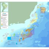
Brazil: TGS, CGG in Foz do Amazonas 3D Survey
distribution. The nearby Zaedyus discovery in French Guiana and the Narina and Venus wildcat discoveries on the conjugate margins of Liberia and Sierra Leone support resource potential in the Foz do Amazonas Basin, the companies said.Early-out PSDM products will be available in Q4 2023, with final products available from Q3 2024.The project is supported by industry funding
Teledyne Geospatial Partners with Seabed 2030 to Study Submarine Impacts of Volcanic Eruption in Tonga
they facilitated the monitoring of data quality and coverage, with new data being used for comparative studies against previous maps to assess the effects of the eruption on marine life and seafloor composition. Software provided by Teledyne CARIS will also be used to process the data to generate the final products.“As the leading developer of hydrographic and marine GIS software, Teledyne CARIS’ contribution to TESMaP has been invaluable,” commented Seabed 2030 Project Director Jamie McMichael-Phillips. “We are grateful for the provision of this software which has truly been a force
CGG Kicks off OBN Survey in US Gulf
be processed by CGG Geoscience’s Subsurface Imaging in Houston. CGG said implementation of its most advanced OBN processing techniques will provide a fine-tuned velocity model and improved definition of drilling targets.Preliminary products will be available in the third quarter of 2019, and final products are expected in the first quarter of 2020.Supported by industry prefunding, CGG’s Mississippi Canyon Node survey paves the way for further CGG multi-client OBN surveys in the future, CGG said.Sophie Zurquiyah, CEO, CGG, said, “We are pleased to initiate our first multi-client OBN
Mapping the Future
is as important as any other and all had some innovation built in – and it is this cohesive approach to producing information from the bathymetric data collected that allowed our team to be as successful as we have been so far. Each piece is an important part of the puzzle – with the final products, whether images of the sea-floor or bathymetric charts showing the morphology and character of the seafloor, being the main objective of the team’s entry. USV Maxlimer has been successful as she offers the means to deploy, retrieve and manage AUV operations flexibly, in either remote or
CGG Begins Deepwater Survey Offshore Brazil
CGG’s advanced full-waveform inversion (FWI) technology in its Rio de Janeiro Subsurface Imaging Center and merged with the Constellation reprocessing project to provide a regional broadband image of this prolific basin. Fast-track products will be available in the fourth quarter of 2018 and final products will be available in the second quarter of 2019. Constellation is a 44,000 km2 project that upgrades CGG’s existing Cluster and Cluster Extension surveys with its latest subsurface imaging technology, including 3D deghosting with bandwidth extension and TTI FWI velocity model


