SYRENE: An Underwater Embedded Artificial Intelligence Camera for Invasive Fauna Monitoring
due to its intense predation. It disrupts biodiversity and local food chains. [1]A lionfish in its natural habitat. Credit: Adobe Stock/crisodSYRENE V1, a lionfish detectorThe SYRENE prototype was initially developed in 2020 as a demonstrator to illustrate the capabilities of embedded deep learning image processing. The inner hardware architecture is simple and low cost, with an electronic board (Raspberry Pi 4B) allowing connection to an Intel Neural Stick V2 VPU (Vision Processing Unit), which accelerates the processing of images or videos (640*480 pixels) from a Raspberry Pi OV5647 5 Mpixels camera
X-Ray Devise Boosts Underwater Inspection Safety
.“Until now, no practical underwater X-ray generator existed,” said ORNL’s Paul Groth. “Seeing inside submerged objects required a source of gamma radiation that posed safety risks for the diver and the marine environment,” and usually also caused delays for image processing on land.The innovation is being commercialized by industry partner The Sexton Corporation and won a 2025 R&D 100 Award for innovation.The new imaging platform, which has been field tested in ocean environments, could eventually be enhanced for inspecting ships and weld joints on bridge supports
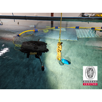
Money Pours in for Hull Cleaning Technology
cleaning speed, along with a debris collection system capable of filtering and retrieving organic material at the micrometer level.Sony brings advanced technologies to the project, including global-shutter image sensors that enable distortionless high-sensitivity image capture of moving objects, image processing technology adapted for turbidity, particulate matter, and other undersea conditions, and real-time self-position estimation systems.Meanwhile, the Port of Auckland is in the final stages of developing an in-port biofouling solution to clean niche areas of ships in partnership with New Zealand
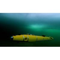
Yanmar, Sony Form Joint Venture for Underwater Sensing Technology
cleaning speed, along with a debris collection system capable of filtering and retrieving organic material at the micrometer level. Sony brings advanced technologies to the project, including global-shutter image sensors that enable distortionless high-sensitivity image capture of moving objects, image processing technology adapted for turbidity, particulate matter, and other undersea conditions, and real-time self-position estimation systems.By integrating Sony’s core technologies into Yanmar’s ROV, the project aims to enable underwater image clarity, 3D data generation, and precise self-position
SeaMe Project to Leverage AUVs, AI to 'Stand Watch' in Offshore Wind Farms
for sound ecological analyses, providing valuable insights into the living conditions within the waters of wind farms.In addition, researchers are developing an AI-based video monitoring system that will enable the AUV to detect fish and marine mammals. This technology uses machine learning and image processing, allowing the robot to continuously improve its ability to identify marine life. AI-based image analysis aims to replace invasive and CO2-intensive methods such as trawling, and provide accurate, continuous in-situ monitoring of marine life without disturbing their habitats.The RWE Kaskasi offshore
Voyis Vision System Certified by BV
without additional in-field verifications, simplifying and expediting operations in varied underwater environments.Each Discovery Stereo unit produces clear, high-resolution 3D reconstructions in real-time. With high-resolution global shutter sensors, a distortion-free dome viewport and advanced HDR image processing algorithms, the Discovery Stereo Vision System captures precise and accurate datasets even in dynamic underwater conditions. These advances, along with optimized stereo baseline spacing and precise camera synchronization, make the Discovery Stereo a top choice for complex underwater inspections
Kraken Joins Forces with US Navy for SAS Sensor Research
(NUWC) in Newport to conduct joint research into advanced signal processing techniques for the current and future generation of Synthetic Aperture Sonar (SAS) sensor technologies.The cooperative research and development agreement signed between the parties also includes exploration into enhanced image processing techniques such as data fusion, image registration, multi-spectral image enhancement and automated target recognition.Kraken Robotics has engaged in several similar R&D agreements with U.S. government agencies since 2012, including NUWC Division Newport, NOAA’s Office of Ocean Exploration
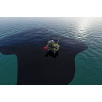
Aker BP Hires Contractor for New Oil Spill Detection Solution
at the operator’s fixed and floating installations on the Norwegian continental shelf.Aker BP will equip installations Valhall, Ula, Edvard Grieg, Ivar Aasen, Alvheim and Skarv with the new and upgraded oil spill detection solution.The upgraded, radar-based oil spill detection system uses image processing technology that enables much higher sensitivity, which allows it to detect even smaller oil spills, according to Aker BP.“The new solution has resulted in higher sensitivity, which means that smaller spills will be detected but less false alarms. It also re-uses hardware that is already
New Sensors Expected to Reduce Illegal Immigration Across English Channel
kilometers of coastline along the Nord and Pas-de-Calais region.Equipped with the CYCLOPE software, SPYNEL panoramic surveillance cameras monitor day and night over a 10-kilometer radius. The infrared sensors instantly alert police command centers if migrants are detected taking boat to sea."Image processing and artificial intelligence algorithms have been developed on the CYCLOPE software to trigger an alarm only in case of detection of groups of people near the water, to avoid false alarms and act quickly. The SPYNEL solution is ideal for this need because it allows continuous and intelligent