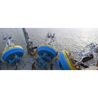
OOI‘s Pioneer Array Relocating to Southern Mid-Atlantic Bight
and deep sites of the proposed array. The deployments will supplement computer modeling to ensure the mooring designs perform as expected in the MAB environment. Once the array is fully operational in 2024, the ocean data collected will be available online in near real-time to anyone with an Internet connection at Oceanobservatories.org.“This new Pioneer Array location in the MAB offers many opportunities for scientists to obtain data to further their research, and will provide better insight into conditions in the area for a variety of stakeholders,“ said Al Plueddemann, Project Scientist

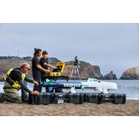
AutoNaut Completes a 16-week, 4,000-mile Mission on the Atlantic continental shelf break
effective baseline detections at the higher frequencies; ADCP and CTD data is good, and analysis will show whether this is a worthwhile way to collect surface data relevant to ocean currents and climate changes in future.Remote Operators (pilots, who can be based anywhere in the world with an internet connection) must be given a clear brief on how a particular boat is wired up. In this case the GNSS was wired in with the CTD rather than the ADCP, for which the GNSS data is required. Normally this would not matter, but when the CTD was cycled to save power that section of ADCP data was
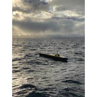
Case Study: Autonaut Put to the Test
effective baseline detections at the higher frequencies; ADCP and CTD data is good, and analysis will show whether this is a worthwhile way to collect surface data relevant to ocean currents and climate changes in future.Remote Operators (pilots, who can be based anywhere in the world with an internet connection) must be given a clear brief on how a particular boat is wired up. In this case the GNSS was wired in with the CTD rather than the ADCP, for which the GNSS data is required. Normally this would not matter, but when the CTD was cycled to save power that section of ADCP data was
Meet NOUS: An Underwater ‘Artificial Mind’
array of self-cleaning cameras and microphones, which are either connected by optical fiber and electrical power conductor to the nearest shore, or to a floating platform on the sea surface. On the shore or on the platform there is a photovoltaic panel power supply and communication devices for Internet connection.On the occasion of the successful completion of the initial operation phase of the "NOUS" system in Alonissos, more detailed information and perspectives are presented in this article.The system was installed in February 2020, at the ancient shipwreck of Peristera, at Alonissos island
Bedrock Launches Fully Electric Submarine Ocean Exploration & Survey Platform
. It is agnostic to the data acquirer, meaning anyone that touches seafloor data from raw to processed can have a centralized place to store and work with their data.Within its current services, Bedrock is launching a free tier of 50GB of private seafloor data storage, which enables anyone with an internet connection a way to publish survey data to the free, public ocean dataset, as well as easily download anything already within it. Bedrock’s goal with this is to encourage the public to contribute any obtained marine data to the public map, in the simplest way possible
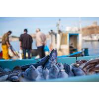
Fishermen Turn to Apps and AI to Tackle Climate Change
dire situation,” she told the Thomson Reuters Foundation.The website has a resource library where fishermen can search for topics of interest, free online courses, a community forum, discussion groups, an events page and a blog section.Although it requires a smart phone or computer and internet connection to access—which is often patchy in coastal areas—Rife said it had low data requirements and they are looking at ways to enable users to view its information offline.The website’s resources can be easily shared via WhatsApp, Facebook or Twitter—platforms already widely
Ship Repair: Inside the $60m Refit of RV Roger Revelle
anticipating things like these low earth orbit systems that would be coming out soon that will allow even higher bandwidth at lower cost in a broader geographic area.”“We did a demonstration with Roger Revelle on sea trials, a test shot with a SATCOMs provider (where we) bumped up the internet connection on the ship to be equivalent to about what I experience at home. All of the sudden we went from a situation where you could barely get an email out to streaming video and real-time sending undecimated data sets, big data sets back to shore to be analyzed in near real time and returned to the
Miros RangeFinder Achieves Certification
accuracy in all weather conditions. The sensor is dry-mounted, meaning no parts are submerged in water, eliminating problems with wear and fouling associated with submerged equipment.RangeFinder is available as an IoT-based sensor, meaning that it is truly plug-and-play, needing only power and an internet connection to provide secure local and remote real-time ocean state data to any device.The sensors can also be complimented with Cloud services from Miros, such as web displays, database integration, data processing and device management services, making weather data available to all stakeholders
Researchers Set out to Study the Southern Ocean
, and by Peter Foden at the National Oceanographic Centre in Liverpool. Dr. Maqueda explained, “It is easier for me to use a satellite phone from the RSS James Clark Ross to call Nigel and Peter and ask them to control the Wave Glider from thousands of miles away as they have better internet connection. They have a five minute delay whereas it can take hours for me to pass on a command through the remote control in the Antarctic, even when relatively close to the glider.” Most of the data can be received almost immediately from the vehicle and relayed back to the UK and to